Reinhold Lubenau (1556-1631) traveled in 1587 as a pharmacist in the entourage of the ambassador Bartolomaus Petz, who was sent by the Holy Roman Emperor Rudolf II to deliver the customary tribute to the Ottoman Sultan. Lubenau, from Königsberg (Northern Germany), began his journey on a ship along the Danube River and continued overland from Belgrade to Istanbul. His accounts of Istanbul during the tumultuous reign of Sultan Murad III are quite intriguing. Despite his admiration for the Turks, he could not help but criticize them due to the prevailing perception of Turks in Europe at the time. In his diary published in 1628, he highly praises Turkish culture and especially the soup kitchens. His diary, which is quite detailed, also includes his observations and comments on mythology, history, botany, and zoology in every place he visited. Lubenau was the first foreigner to take an artifact from Troy back to his country. In his accounts, he mentions leaving a plaque he took from Troy with a Venetian compatriot because it was difficult to carry. His observations about Troy and the Çanakkale region are quite detailed and interesting. In 1587, Lubenau set out with an Ottoman galley under the command of Kaptan-ı Derya Hasan Pasha, and after passing through the Dardanelles, the galley toured the Mediterranean and returned to his country 1.5 years later. Some researchers suggest that the part of this journey related to the Mediterranean is largely fictional:
"Gelibolu is a very old and large city located at one end of Chersonesco Tracico, but it has no walls. It has been famous since ancient times, and its harbor can safely accommodate many ships. Although very large ships cannot fit into the harbor, they can anchor safely in front of it. The fortress on the shore of the harbor, once very strong and secure, is now in a very dilapidated state. Nevertheless, a large number of guard soldiers are stationed in this fortress. Çardak Mosque (1811, Antoine-Laurent Castellan)
In the shipyard near the fortress, there were ten large galleys and also other boats and 20 cannons around. There is a large and strong customs building resembling an octagonal tower on the seashore. The Turkish rulers derive a large income from the customs duties collected here. Because goods brought by ships are unloaded here, customs procedures are carried out, and then they are dispatched inland. Especially Armenian goods, woolen silk fabrics (Grobrum, Moher) and carpets produced in Bursa, Ankara, and Mount Olympus, are sent to other countries, even as far as Poland, after paying customs duties here. Turks, Greeks, and Jews live in the city. Flat weaves are also produced here. The city is 70 Italian miles away from Marmara Island...
Turkish ships are freer; they do not need to stay here for more than a day, and if the wind is favorable, they are not detained for more than half a day. Therefore, Christians wishing to travel to Syria or Alexandria prefer to board Turkish ships and can often reach Alexandria in 10 or 12 days. Especially at the end of August and throughout September, the wind blows mostly from the north, and in spring, from the south. This is a place where captives prefer to escape by various methods. In the garden of the monastery of Saint Augustine in Gelibolu, Genoese monks grow citrus varieties such as lemons and oranges, and pomegranate trees. The head of the monastery showed me a vine that bears fruit all year round. Thus, they never suffer from a shortage of ripe grapes, and the vine yields fruit seven times a year. I wrote down what the monk told me as it was, and during my stay there, I saw ripe grape clusters on the vine with my own eyes. There is a very elegant Greek church named Saint Mark here. Dionisus, the head of the church, a pious man born on the island of Chios, showed me things worth seeing around. Meanwhile, I also visited the grave of Mr. Hans Ludwig Lichtenstein, who came from a noble family and brought gifts sent to the Ottoman "Gate" in 1584. This gentleman was very upset when his brother, Mr. Georg Hartman von Lichtenstein, died in Istanbul (Constantinople) on January 19, 1585, and lost his health both physically and mentally. Therefore, he decided to return to his homeland, sent most of his servants overland to Vienna, and boarded a Venetian ship to go to Venice, but he could not go beyond Gelibolu and died here...
Outside the city of Gelibolu, there are very beautiful gardens where various vegetables are grown: lettuce, radish, garlic, squash, melon, watermelon, etc. What the Turks call watermelon is called Anguriae in Italy. These are sent to Istanbul (Constantinople).
We saw many round, regular mounds in a flat field. In ancient times, Thracian kings were buried here...
I saw many flat-topped and open-stern ships at sea. These are built in this way to easily load camels, horses, and donkeys traveling from Europe to Asia or vice versa. Gelibolu is the last of the four Turkish cities located on the coast of Thrace, and "Propontis" ends here. The sea starting from here and extending to the Aegean Sea is called "Hellespontus." Because, according to what is written in books, Helle, the daughter of King Atamantis of Thece, drowned here. In Propontis and especially in Hellespont, reeds grow abundantly, and the locals cut the reeds like mowing grass and mix them with clay to cover the flat roofs of their houses with this mixture. The locals call this "Arkeilli"...
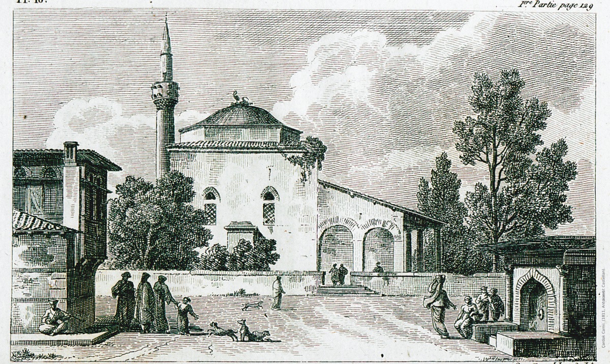
On the night of September 27, all the galleys weighed anchor and set out, moving away from Gelibolu towards the Asian shore. We came to the place where Osman, the first Turkish ruler, once set out with a raft made by tying trees together with a handful of warriors to capture the fortress of Gelibolu. The bey of Gelibolu has a farm and a beautiful garden there. Nearby is a large village with a beautiful mosque (Çardak R.A.).
The caravanserai of the village is large enough to accommodate perhaps a thousand camels. Every day, camel caravans loaded with various goods from many cities of Bursa, Ankara, Karaman, Bithynia, Phrygia, and Mysia come here, some loads are unloaded, and some are transported with camels to the opposite shore, to Gelibolu. Thus, from time to time, two thousand, three thousand camels are found together in this village. The Karamenderes (Skamandros/Scamander) or the river called Xantus by poets, which originates from Mount Ida and flows into the sea near the fortress of Abydos, passes near the village (The river he mentions must be Sarıçay R.A). The river Simenotis, mentioned in the works of many writers, is also in this region. However, this river is not as deep as it is believed to be according to what is written about it. One can cross from one bank to the other on horseback or on foot. I do not know if this Scamander river is the Granico (Granikos/Biga Çayı n. R.A) stream where Alexander the Great once defeated the commanders of the Persian king Darius. According to a book I read, Alexander the Great gave his name to that river. They said that the Granico river also originates from Mount Ida. I could not identify the existence of another river where this great victory could have been won. Alexander repaired and renewed the city of Troy and began to build the temple of Palladis. After Alexander's death, Lysimachus completed this temple, and the city of Troy was beautified. I searched a lot for the city of Troy near Mount Ida, on the banks of the Scamander river. However, at the foot of Mount Ida, on the left side, there was a large forest of pine or pitch trees... The Captain Pasha had ordered the day before to cut wood from this forest, load it onto donkeys, and transport it to the galleys. Because he intended to sail the sea and visit many places, and since there was no wood in those places, especially in the Cyclades islands, except for some useless myrtle bushes, he would take this wood there. Since a whole day would be spent on this wood transportation, the Englishman I mentioned earlier came to me and suggested that we ask the Captain Pasha for permission and visit the ancient city of Troy, known by the names Ilia, Dardania, Teucria, Trositzo near Mount Ida. I asked one of the captains on the galley to request permission from the Captain Pasha for me. Since I had already gained the favor of the Captain Pasha, he immediately granted me permission and assigned a janissary who knew the area well to accompany me... I was very happy to have the opportunity to see the old, ancient city of Troy. Because many people now believe that no trace of this city remains, and some even claim that this city is merely a poet's figment of imagination, "figmentum poeticum." Vergilius wrote in his work: "Campus ubi Troya fuit" (Troy has indeed fallen). And Ovidius says, "Troya icacet certe Danais invisa puellis. İbidem Seges est ubi Troya fuit" (Hated by the daughters of Greece. In the same place where Troy was, wheat is now sown). But now nothing can be seen there.
After each of us took some provisions, my English friend, the janissary, and I mounted our donkeys. I promised the donkey drivers a tip if they made the animals run fast. After having our meal in the village, we set off. We moved quickly and reached the edge of the forest, almost to the right of Mount Ida. There we dismounted from our donkeys, and I gave tips to the donkey drivers to please them. We continued on foot, heading towards the hill on our right where we guessed the city of Troy was located. This place was half a German mile away from the forest. We could only see the mountains from a distance. If we had come this far with donkeys, we would have traveled faster. We realized that the distance between here and the Aegean Sea was much shorter. Because from Caput St Mariae, formerly known as Jarganum, extending towards the Aegean Sea, the ruins of the city of Troy could be seen very well (the place described is the ancient city of Alexandria Troas opposite Bozcaada. R.A.). In many places, some large sections of the city walls still stand, and they are quite close to the sea. As we got closer, the ruins on top of the hill where the city was located appeared; these were large wall fragments remaining from the old walls, as I mentioned earlier... A large part of the walls was built from black, hard, square-cut stones obtained from a nearby mountain called Assos, just like we saw in the city of İznik. There is also a city named Assos, which I learned from the Greeks was built from the same hard, black stones and took its name from Mount Assos. Among the walls, many remains of old towers can also be seen...
From here, it is possible to see the entire city and the land extending to the sea, and further ahead, the island of Bozcaada (Tenedo/Tenedos)...
After the galleys returned with the janissaries they took from Gelibolu, all the ships of the fleet set sail and set off. The rowers also had to row. After traveling all night, we arrived on the morning of September 28 at the place called Dardanelle, where two fortresses once known as Abydos and Sestos are located. This entire area is known as Dardania. The Turks call both fortresses Boğaz hisarları (Bogazaslar), meaning "fortresses at the sea passage." On the other side of the sea, the fortress on the European side is called Sestos, and the surrounding area is also called Dardania. Because opposite it, behind Abydos, are Troy and Dardanio. In fact, all the regions of Graecia, Bithynia, and Pontus, which were once under Roman rule, are called Romania, and the Turks also call these places Rumeli. As a result, the land around here today retains the name Dardania, Troas, or Troy land, but anyone can use the name they prefer. Here the sea narrows so much that one can easily cross from one fortress to the other over the Hellespont with a small boat.
As soon as the fortresses came into view, the galleys of the fleet lowered all their sails and, following the commands given by the sound of the trumpet, lined up in a crescent shape and took battle formation, taking the galley of the Captain Pasha right in the middle. The Captain Pasha sent letters to the fortresses with a frigate. Meanwhile, cannons were fired from the galleys, and the ship and mast were adorned with beautiful flags. The people in the fortress also hoisted their flags, and a series of cannon shots were exchanged over the sea. This salute lasted for about half an hour. After that, upon a signal given from the fortress of Abydos on the Asian side, all the galleys of the fleet approached the fortress of Abydos in a certain order, amid cannon fire, and anchored...
The fortress of Sestos on the European side (Kilitbahir Fortress, the author mistakenly thinks that the Ottoman fortresses and the ancient fortresses of Sestos and Abydos are the same. R.A) is heart-shaped. In the middle, there is a high, strong, angular tower, and it is also surrounded by a wall. There are 27 large cannons lined up towards the sea. Behind the fortress, there is a large forest of pitch trees. However, the pitch obtained from these trees is much darker in color than the pitch from the trees on Mount Ida. The mountains are so close to the fortress that it is possible to observe and fire at the fortress from there. A large number of soldiers are stationed in the fortress because the Turks attach great importance to these fortresses for the security of Constantinople. Around the fortress, there is a fairly large, beautiful settlement called Maito (Maydos/Eceabat, the author mistakenly thinks that Kilitbahir is Maydos, R.A) and its sea side is protected by a wall. The fortress of Abydos in Asia Minor (This is Çimenlik Fortress; however, it is confused with Nara Fortress, n. R.A) is more secure and is built on a plain. It is rectangular and secured with strong bastions made of cut stones. In the middle, there is a large and strong four-cornered tower with large cannons on it. Although it is not surrounded by a rampart, it is protected by a wide moat. Twenty large cannons are placed in the pits on the side facing the sea. But they have no wheels, only their rear sides are secured with large stones. Thus, they cannot be moved. Some of the cannons on the seashore have wheels. Nearby, there are a few small houses where Greek fishermen live. The houses are single-story and, as is very common in eastern countries, they have no roofs. This place houses a small village. Very close by, the Scamender or Xhantus river (the author here confuses Sarıçay, the ancient Rhodios river, with the Scamander river, n. R.A) flows into the sea. It is claimed that this region is the key to all of Turkey, but in my opinion, this is a very exaggerated claim. In fact, the purpose of building these fortresses is to hold back an enemy fleet wanting to attack Constantinople here. Christian ships sail so close to here that they can be hit if fired upon. Ships going to or coming from Constantinople must anchor in front of these fortresses. Here, a search is conducted inside the ship, and those coming from Constantinople must show a passport issued by the kadı or the sultan himself. Galleys cannot pass here without a passport.
However, despite all the strict measures, a galley full of slaves managed to deceive the guards here...
After visiting the fortresses, the Captain Pasha gave the order for the fleet to move. The sails were set, and the journey began. Not far from the fortress of Abydos, many old and large building ruins were seen on a plain. On the shore, old, large walls resembling defense structures built of bricks were rising. These are called Kaput Gimensium. The building had collapsed and turned into a pile of bricks. On a promontory in that vicinity, there is the ancient settlement of Sigaeum (located at the entrance of the Dardanelles in the Aegean, where the Scamander River (Karamenderes) flows from the Trojan Plain into the strait, some travelers have identified it with the ancient Sigeion settlement built on top of the Greek village of Yenişehir; its current name is Orhaniye Tabyaları, n. R.A) Capo de Janiczari. Here, there is an easy road between two promontories to reach the ruins of the ancient city of Troy. In the past, there were large cisterns and food depots in this region, but most of them have been destroyed. Only the cisterns collecting rainwater still stand. We turned the helm to the right and passed in front of the mountains on the peninsula known as Chersoneso tracico and today called the arm of Saint George (Gelibolu Peninsula). The tombs of Hecuba (the second wife of King Priam of Troy) and Protasilai (Protesilaos, a Greek hero mentioned in the Trojan legend. As soon as the ships landed, he was the first soldier to set foot on enemy soil and was killed by Hector) are here..."