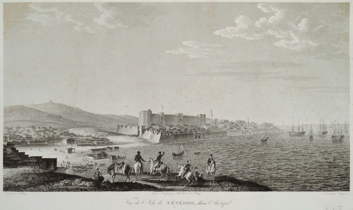
"Tenedos (Bozcaada), October 14, 1824
Flat Bozcaada (Tenedos) and the round mountains surrounding it like a circular base greet us. The wind slows down as we enter the shelter of the southern mountains. We anchored in the small harbor south of the castle, which rises on the slope ahead with its bastions and towers. The view of Bozcaada (Tenedos) is quite barren, with only some vineyards and a few olive trees in the flat valleys breaking the monotonous brown-gray soil. There are no trees or bushes even at higher altitudes, everywhere is bare soil. Behind four cliffs, like a crown in the mists, the high Gökçeada (Imroz) and the mysterious Samothrace (Samothraken) make a transition to the prominent Troy shores with a long mountain range spreading much further away. Mount Ida stands like an intermediate wall between the sky and the earth; it can even be described as a staircase leading to the sky if one wishes. The mountain rises from north to south, first gently, then in zigzags southeast and south; in the east, it joins the tower-like Gargarus (summit); because here it descends towards Cape Lektum, and the wild sea begins too far away to be seen from here...The Romano Knight in Izmir (Smyrna) had offered me to go to Istanbul (Constantinople) on an English ship because foreign warships were prohibited from passing through the Dardanelles. Since the storm forced me into the situation and Montecuccoli could not sail towards the Dardanelles due to the wind, I really needed the axe of Tenedos to untangle myself from the knot I had fallen into. I landed on Bozcaada, rented a sailing ship to go to the Dardanelles, and decided to go to Istanbul, only a few hundred miles away, trusting in my lucky stars. I landed at the place where the large Turkish castle, protected by walls on all sides, stood and walked through narrow, ugly, dirty, and poor wooden huts, slightly better stone houses.
Where are the traces of those times on the almost unmarked ground?
Where is the Aeolic city described by Herodotus (I, 151)? How will I recognize the coast where thousands of Achaeans hid and later destroyed the sacred walls of Ilion? Where is the very striking temple of Smintheus?
October 15, 1824
Yesterday at noon, we tried to leave Bozcaada harbor with oars, opening four sails, three aft and one cross sail. With this help, we flew to the Asian mainland. I asked the Greeks accompanying me to take me to the rather long Troy shores. We sailed towards a very large tumulus (artificial burial mound) that caught my eye yesterday and today and which I saw on Kaufer's map as the tomb of Asyetes.The right side of Kumburun extends flatly towards the sea, so the Troy plateau continues to rise, and the Peneleus burial mound, squeezed between the hills, looks out towards the sea. In the background, the light blue peak of Mount Ida appears as if it were a burial mound created by gods and goddesses. On the left, the mountains of Samothrace island, like a night, "stare unblinkingly" at Gökçeada. Scattered irregular trees cover the Kumburnu coastline up to the Troy cape, and the elevation stands out like an intermediate wall between the Aegean Sea and the Karamenderes River (Skamander). I noticed a new bed of the river, which is described most beautifully among all rivers, in the bay south of the Troy cape, and it seems that this path continues inward, covered with high poplar trees and small groves. An English frigate and small warships with the same flag departed from where they anchored at the Troy cape. A sailing warship was anchored, waiting on this sacred shore. The Asyetes tumulus was located much further inland; the Peneleus tumulus, surrounded by rocks, stood like a crown on the Troy cape, battling the storms of the sea. On the outermost part, there was a slope made of white stones resembling a coffin...
The harbor surrounds the magnificent Antilochus tumulus to the northwest, showing the Siegeium (the place where the Old Yenişehir village is located) ridges and the protruding arm of the Thracian peninsula. The sun's rays illuminated the castle and city on the European shore with all their warmth.
After rounding Siegeium, which Herodotus defined as the boundary line of Asia (4,38), the Asian castle built entirely on the sand dune revealed itself. The Achilles burial mound on this side stands like insignificant piles of stones next to the European and Asian castles. This tumulus, which has lost its importance, stands shattered and very sorrowful; leaning against a wall, it rises towards Cape Sigeion as if steps made by human hands. On this solid shore, nine windmills cover this poor place where the Temple of Athena is located in the same order.
The harbor is now flattening, and behind a few olive trees shading the Achilles tumulus, the Patroclus tumulus can be seen, beyond which lies the Turkish cemetery with long cypress trees (Kumkale Cemetery). For millennia, only death has disturbed these classical lands! I toured the fortress and settlement at the mouth of the Simois into the strait. There are four towers on the outside, the front two are connected by strong intermediate walls and surround the fortress in a semicircle...
From within the settlement, three minarets and numerous huts can be seen; rows of trees remind one of the memories of time like a painting...
Soon the old castles built by Sultan Mehmed the Conqueror in the Dardanelles (Dardanellen) came into view. The one on the European side, built leaning against a slope, is very ugly; the one on the Asian side, built on a flat area, extends into the Dardanelles. In front of the second castle, a wide bay opens up, the same is true for the castle on the European side; thus, it gives the impression of a lake surrounded by mountains and numerous hills, surrounded by mountainous and fertile fields. Especially in the north, the mountain peaks of the Thracian peninsula ridges stand out over the wall-like block. We approached the Asian castle, and it was already evening. Numerous merchant ships were waiting; a Turkish warship and some war fleet were anchored in the middle of the Dardanelles.
I landed at the house of the English consul and was warmly welcomed by the Venetian Mr. Xanthopolo.
Troy (Pınarbaşı/Balllıdağ R.A.) October 18, 1824
It was evening, and I was sitting at Hector's tomb, watching the surroundings. The sun descended towards the sea and left a golden mist on the surface, then the evening mist covered its shining face like a veil, simultaneously covering the famous city and the dark extension of the Thracian peninsula...
How Homer comes to life after such scenes! At such moments, one understands him, and the finest details become comprehensible to the reader.
While I was still sitting on the summit of Pergamon, the sun had set, and when I returned to the village (Pınarbaşı village), our translator reminded me that it was two in the night, and food and bed awaited me. In the dark, I was walking in the half-ruined house of the Pasha, made from the remains of a Roman temple. My eye caught the large marble block in front of the mosque, which Lechevalier saw leaning against a triglyph and a Corinthian capital. But now its supports were granite columns. I am still trying to find where the Sakaik gate is; it could be a hundred steps away from the house I stayed in..."