Entrance to Western Troad and the Dardanelles (1784, Aguste de Choiseul-Gouffier) Written by Edmund D. Chishull, who worked for an English company in Izmir in 1698, but published in London by his son in 1747, the work describes the region from Western Anatolia to Istanbul with its historical features. What makes these impressions interesting is that Edmund Chishull visited the same places at the same time as Evliya Çelebi and narrated his impressions. The fact that they were written from different perspectives and with different cultural backgrounds and styles yields interesting results in terms of comparing the travelogues. Especially in contrast to the entertaining style of Evliya Çelebi's impressions, Edmund Chishull's more detailed and informative narration stands out:
"March 29:
This morning, with a light and contrary wind, we turned around, seeing the town, the harbor, and the fortress of Lesbos clearly between the land and the island. The fortress was surrounded by a large wall descending gently from the edge of a low hill. This coast of the island was filled with villages with large fields and pastures beautifully cultivated. In the distance, large forests, said to be abundant with deer, were visible.
Today, we could not go further than the island of Musconisia. This island was between the island of Lesbos and the mainland of Ayvalık. We arrived here to anchor at midday. Our anchorage was at the mouth of the Idacan or Adramyttian (Edremit) gulf. The gulf was formed between Cana and Baba Burnu (Lecton). The peak of Mount Ida (Kaz Dağı), rising opposite the land of "Troas," was covered with snow.
March 30:
Around four this morning, a gentle breeze began. We are advancing between the island of Lesbos and the mainland of Ayvalık. Siguri, the ancient Sigeium, and Baba Burnu form a very narrow strait. We begin to turn the last cape near noon and see Gökçeada (Imbroz) and Bozcaada (Tenedos). After advancing for hours between Bozcaada and Troy in calm weather, the island of Limni (Lemnos) was seen. The flat terrain of Limni and the high peak of Athos (Aynaroz) were in magnificent view.
March 31:
Today at nine, the wind turned direction, and we advanced between Bozcaada and Troy. We observe that the views change within short distances of approximately six or seven miles. Bozcaada is a medium-sized compact town fortified with a fortress located right on its shore. The sea side lacks a deep gulf or harbor facility. The land side is a flat and green island defensible with the support of a round hill. It has a rich and fertile appearance as its fame suggests. Today, as the wind was not favorable, we advanced very little in calm weather. Between Bozcaada and the Phrygian regions, on one side Troy, on the other Bozcaada, Imbroz, and the beautiful views of the Samothrace fields were watched, and at six in the evening, we anchored under the mountainous cape of the famous Yeniköy (Siegeum).
April 1:
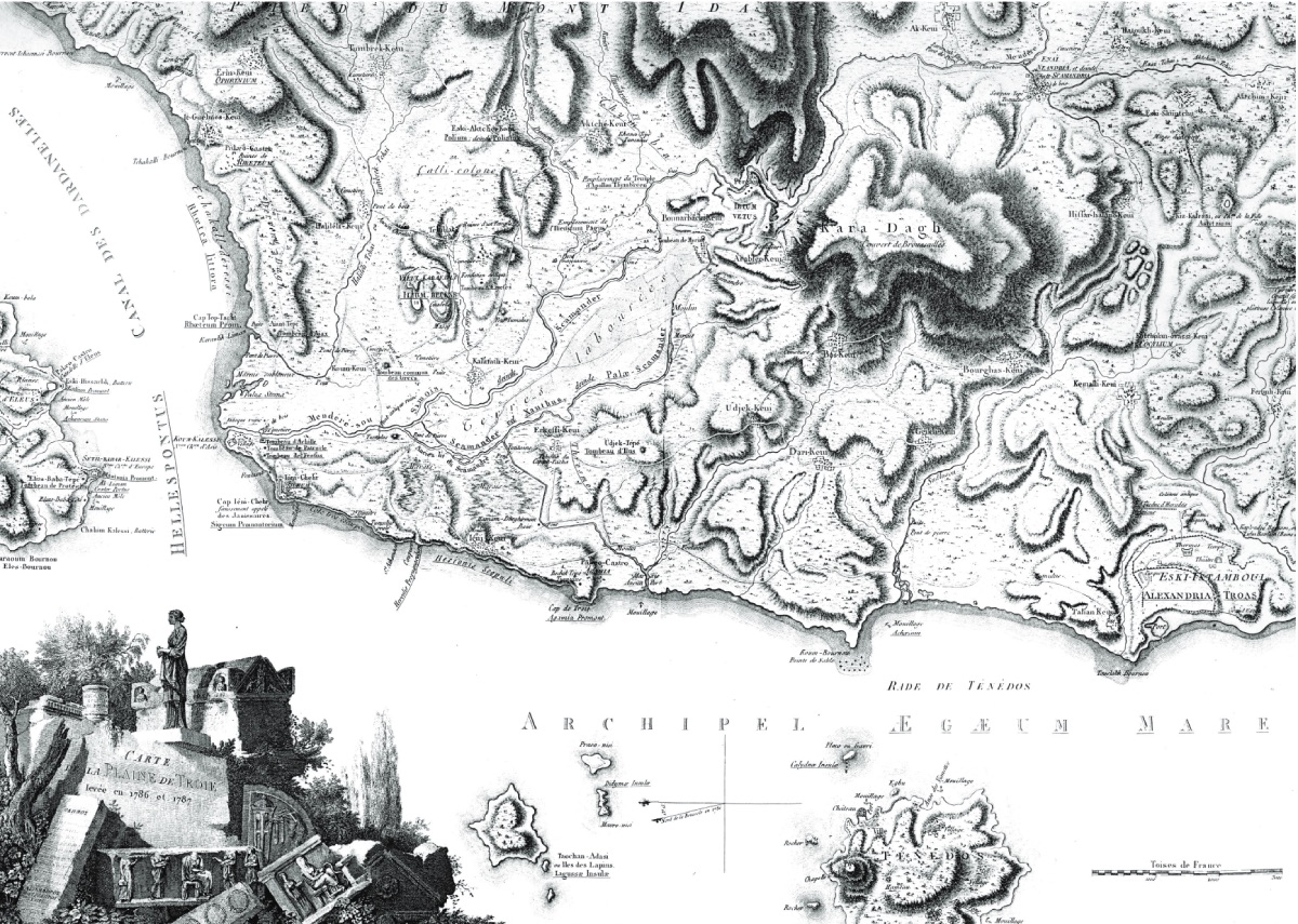
Early in the morning, in very calm weather, we had to tack all day to pass the Dardanelles (Hellespontus) from Yeniköy, and finally, we managed to hold on, so to speak, in the vicinity of the Anatolian Yeni Hisar. At the cost of great fatigue, after two or three more tacks, with the help of the wind that did not withhold its grace from us, after advancing two leagues from the fortress, due to the very dark night and the very narrow channel, our captain found it appropriate to anchor the galleon. It was very natural to recall the history of Troy in this place. In clear and calm weather, from the stern cabin, I fed my eyes and mind with boundless curiosity, watching the entire shores of the city of Troy from a suitable distance. According to Strabo, the area called ancient Troy by the current Greeks, in its broad sense, extended from the mountainous cape of Bababurnu, opposite Bozcaada, in a sweet green terrain, to the Dardanelles. We had sailed from the head of this strait especially to the vicinity of the land piece called the plain of Troy. Since the story of this famous place is told vaguely and incorrectly by current travelers, I endeavored to describe its location and boundaries in as clear and definite terms as possible.
From the Yeniköy peninsula, after sailing five miles to the opposite of the mouth of the Menderes, and then two miles further to a small cape called Rhoeteum by the ancients, Rhoeteum and Sigeum curved in an unbroken semicircle to reach a base safe for Greek fleets.
However, as Strabo also noted later, the sands carried by the Menderes river covered this base. Thus, a growing landmass formed, and the current Kumkale (Anadoluhisarı) was built upon it. According to Homer's description, the adjacent land piece to the base encompassed distances suitable for armies to fight, set up camps, and conduct maneuvers. During the reign of the last Trojan king Priamos, the shore was more recessed and more regular.
It is not possible to reach a complete clarity about the location by imagining the walls and structures of Troy. Since the time of Tiberius Caesar, to satisfy the curiosity of researching travelers, Strabo assures that not even a small step remains from ancient Troy. Thus, researchers of the time who want to see remnants of Troy expect nothing but the rubble of the new Ilion (another name for Troy) that Constantinus attempted to build there.
April 2:
This morning, we endeavored to continue our journey. However, there was no great progress. Because we could not overcome the continuous and strong countercurrent from the Dardanelles to the Aegean Sea in the light breeze. Therefore, we were dragged back to the place where we anchored in the morning and anchored at the same place again. Taking advantage of this delay, we found the opportunity to have lunch on the Asian shore. In the afternoon, a cooler wind took us a little further than the old fortress. But since it ceased, we had to anchor a second time to avoid being dragged back.
April 3:
Since today passed completely without wind, we continued to remain anchored in the same place. The next day, as the calm weather turned into a contrary wind, we had to continue staying at the anchorage. Some members of our company may not welcome these interruptions, but I am very grateful for this two-day period that passed idly.
Kilya Bay and Surroundings on the Gallipoli Peninsula (1784, Aguste de Choiseul-Gouffier) Although I do not appreciate time spent aimlessly, I was exceedingly pleased to take advantage of an unexpected reasonable opportunity to see the two famous fortresses and the adjacent towns. I walked with great pleasure to the vicinity of the town on the Asian side (Abydos) by taking the captain's boat ashore. The city was large but simple, and no archaeological traces were found. Beautiful glazed jugs specific to the East were made and sold in the town. At each corner of the square fortress, a bastion rose. In the fortress, whose defense was reinforced with water-filled moats, there were about twenty or thirty very large cannons, examples of which can be seen in very few regions of Turkey. The bronze cannons had a diameter of three-quarters of a yard. Beside the cannons, there were specially carved stone cannonballs. According to the information given by the gunpowder officer from Izmir, the gunpowder rights were one hundred and five okkas. I crossed from Anadoluhisarı to Sestos by boat and saw the skill of the boatman to escape the strength of the current described by Strabo. The town is located on the edge of a cliff descending steeply towards the sea. Although smaller than Abydos, it was better developed. It had a fortress with a triangular tower surrounded by a high clover-shaped wall, and its defense was strengthened with a deep moat surrounding it. About thirty cannons, the same or larger than those at Anadoluhisarı, were mounted at sea level to this Rumelihisarı. Beside each cannon, spherical stone cannonballs carved to fit their diameter were piled up.
April 5:
This morning, with the help of a cool wind blowing from the West, we set sail at six o'clock. After passing the fortresses, we came to the town of Eceabad (Maitos, formerly Madytos) one league away from the European shore. Maydos was established on a flat area on the edge of a small gulf. Its fertile fields reflected a prosperous appearance for its people and a pleasant view for travelers. The entire population was Greek. The towns we saw along the shores had plain land conditions, and they were all effective. The pastures were fertile. On the shore where Maydos is located, Lesser and Büyük Galata villages, seen approximately three leagues away, were in good and pleasant positions. We are between Lapseki on the Asian shore and Europe, two leagues away from these villages. Gelibolu is a large town, while Lapseki is a small town. The character and fate of Gelibolu during Strabo's time have now changed significantly. Approximately twelve leagues away from Gelibolu, there is Marmara Island. On the island's very high terrain, there are abundant deposits of durable and veined precious marble. The island's ancient name, Proconesus, later transformed into Marmara from marble. Near here, there are two small islands named Paşalimanı, Kutali, and Alonia (Avşa). Very good wines are made on Avşa Island. Our journey continued with a suitable and lively breeze among the islands adorning the shores of Propontis (the Sea of Marmara) as evening approached. God willing, with this favorable wind, we will have reached Istanbul early tomorrow morning."
February 18:
We turned our path towards Çanakkale by following the trails over the mountains that Homer called noble. While watching the very charming views of wild animals on our right, we could see the entire bed of Gönen up to where it flows into the sea. After three hours, we passed through the old town and fortress called Manyas (Minyas) and the lake and plain named after it. These plains were formerly called Zelia. A river with the modern name Mulvetelee flowed into the lake adjacent to the plain. After five hours, we passed through small hills, beautiful towns, well-cultivated fertile beautiful plains, and large walnut tree forests. After five and a half hours, we reached the bank of a beautiful and wide river. This river was formerly called "Tarsios," but now the Turks mistakenly call it "Tarza." Since the current of "Tarza" did not provide safe passage, we had to board a ferry with three horses together. After walking for about an hour and a half from the flat and green pastures on the left of the mentioned lake, we arrived at Şevketiye (Humumi) and stayed there. We calculated the circumference of the lake, which was easily visible from our lodging, to be thirty miles. The lake, abundant in water, was full of fish. There were also delicious pike fish sent to us from the lake. According to the information given to us, the last river we passed, Tarza, flows into the lake and from there, with a new bed, comes to Mihalcık and immediately flows into the sea with the Simav stream. Beyond the lake, the high peaks of Karadağ (Cyzicus) and Kapıdağı (Cyzicena) were visible.
February 19:
We left the farmhouse where we stayed in Şevketiye at six-thirty. We rode through a pasture until we saw the snowy peak of Mount Ida. In the Adristian region, after five hours, we reached Bozacgı, sometimes seeing and sometimes losing the high peaks of Karadağ. In the same region, we left a large and beautiful stream, which the Turks called "Boclew," on our left (This stream could be the Granikos (Kocabaş Çayı), whose bed curves towards "Cyzicus" (Karadağ)). Two hours later, we crossed a dangerous wooden bridge near Sarıköy (Sorricui) and stayed right beside it. While I was not at the inn, some Turks brought medals to sell. I missed the opportunity to buy them. Mr. Farington did not buy them, suspecting they might be spies.
February 20:
We left Sarıköy around six o'clock. After traveling a bit, we saw a fair said to be frequently held in the area of "Aya Yorgi" and lasting for ten days. Then we passed through a wide and magnificent oak forest and climbed a high and steep hill. It was said that a large amount of gall was obtained from the dwarf shrubs on the hill. The sage scattered at the base of the shrubs smelled wonderful. After traveling for about three hours on the hill, we saw the sea and the Marmara Island on one side of the Kapıdağ peninsula up close. After five hours, we began to descend into a beautiful and green plain. After seven hours, we arrived at Dimetoka (Dimotica), a Sunday town. The town, formerly called "Didymotichos," was named by the putrid crowds. We crossed a medium-sized river in the area on a wooden bridge. However, an hour away from the town, there was a beautiful stone bridge built by the noble Sultan Mehmed IV. The Sultan's road, used by the sultans for wars, was seen to be marked at equal and regular intervals for two carriages. Up to this point, our route always surrounded Mount Ida, sometimes allowing us to see its frosty peak and the streams in its watery basin. Now, we needed an hour to reach our lodging in Pişmetli. However, we lost our way. Under the guidance of a shepherd, one of Mustafa Bey's cowherds, we were brought to a small and charming town an hour away from our path. We were forced to spend the night in the town's mosque. This was a rare occurrence in Turkey. Although the regional imam found the situation abominable, he bid us farewell the next day by saying "May Allah forgive" three times.
February 21:
Through bad roads among frosty hills, we arrived at the town of Ferdağ (Ferdack), half an hour away from the old Lapseki (Lampsacus), the crossing stop of the Dardanelles. The road brought us to the shore of the Marmara (Propontis) sea. After following the shore for about four more hours, we reached our lodging at the narrowest point of the strait between Lapseki and Gelibolu (Kallipolis). We stayed in a stone inn with twelve round and fluted marble columns, which undoubtedly remained from ancient times in Lapseki.
In the courtyard of the mosque in Ferdağ, I saw two Greek inscriptions:
"Good Luck
Klavdion Floron won the senior race in the Pyktin races with great luck.
Race organizer T. Iolio Eleoneos and judge Klavdios"
"Kyros Apoloniu held a funeral ceremony for his father Apolonio Apoloniu and buried him."
February 22:
With God's permission, this morning at nine, we crossed ourselves and our animals from Ferdağ to Gelibolu on the European side in three-quarters of an hour. After enduring the severe seasickness I had to endure during the crossing, we joyfully bid farewell to Asia. By that date, three years and three months had passed since I arrived in Izmir.
Gelibolu was captured during the reign of Orhan, in the Hijri year (Anno Hegirae) 760.
Now it is a large town, but its population is sparse. Although its trade has collapsed, it still has an abundance of sunflowers and cotton. The town, situated on a blind land piece between two gulfs, has two beautiful Turkish cemeteries on the green shores of the small northern gulf, which has a very charming appearance. Among them, there cannot be a more magnificent tomb than the one named Sinan Pasha. Adjacent to the cemetery, there is a mosque and foundations. The structure of the inn within its foundations is very elegant. In the small southern gulf, there are old shipyard sites, warehouses, and wintering galleys. The rocks in front of the town are very interesting. The houses were built with a mixture of natural pebbles, oyster shells, and sand. In the region's Greek church, despite being contrary to its tradition, there were stone reliefs of our savior Jesus and Mary, baptized in the holy Jordan river.
February 23:
We spent today and the next day in Gelibolu waiting for Mr. Farington's caravan. According to Xenophon, the width of the Dardanelles at Lapseki was 15 furlongs (One furlong: 220 meters).
February 25:
We began our forward march from Gelibolu on a flat and pleasant road. The road suddenly rose, and we could see the narrow isthmus of the Gelibolu peninsula (Chersonesus) with the Marmara sea and the Saros (Cardia) gulf, or Sinus Melas, and at the far end, a land piece about three miles wide. After a while, our road turned left, and we came to the blind end around the gulf where the Melas river joins the sea. In the fourth hour of our departure from Gelibolu, we crossed a solid and regular stone bridge. After this, we continued on a stony road to the Christian town of Alalmalı, where our lodging was located. Among the many things our ignorant and poor road guide from the town's people told us during the time until bedtime was the story of paying seventy dollars as a license fee to the bishop of Tekirdağ for his son to be made a priest."