Fortress of Çimenlik on the Asian Side (1784, José Moreno) After the French Revolution of 1789, the Convention Government, which temporarily took control in France, sent a team of experts led by G. A. Oliver to Istanbul towards the end of 1792. Oliver and his team toured Istanbul and its surroundings until 1798, made a brief trip to the Aegean Sea and islands to Egypt in December 1795, and then returned to Istanbul via Syria and Cyprus. During this return journey, they visited the Çanakkale Region and provided detailed information about the area:
"After entering the channel, the wind began to blow strongly from behind us, and with the effect of the current, our ship started to move faster. We were turning our eyes from one shore to the other, regretting that we couldn't watch these places more leisurely. So much so that by ten in the morning, we found ourselves in front of Gelibolu. Gelibolu, the largest city in the straits, was captured by Süleyman, son of Orhan, during the reign of Jean Paleoloque. The city has a population of fifteen to sixteen thousand. Muslim Turks, Jews, and Greeks live together.
A lighthouse is placed on the rocks to guide ships entering the strait at night. There is a similar one directly opposite on the Asian shores. The strait suddenly narrows in front of Gelibolu, so much so that the width of the channel here is about a league. The sea forms a small bay like a ring in front of the city. This also serves as a refuge for ships. The mountain we mentioned earlier gives way to small bare hills here. The opposite Asian shore, on the other hand, appears very beautiful, as if it has come closer to the eyes. After a while, we stopped in front of Lampsakos (Lapseki), which has a pleasant appearance with its fertile and cultivated land. In ancient times, this city, which was much larger than Gelibolu, was famous for its vineyards, gardens, the excellence of its wines, and the beauty of its temples. Especially the devotion and passion of those living here for the god Priape were passed down from generation to generation. All these are now in the past. Currently, it is a village where Turks and Greeks live together. Although there are remnants of old vineyards and gardens, they are in ruins. A mosque has been built on the temple of Priape. Turks perform their prayers here, and the prayers once dedicated to Priap, the protector of the universe, have now been replaced by the offerings directed to Panayia by the Greeks. Until reaching Nara (Nagara) Cape, the Dardanelles Strait does not have an interesting appearance other than the green valleys and hamlets on both sides. The remains of ancient Abidos are still present in Nara. The speed of the ship was such that we covered the distance of more than 15 miles between Lapseki (Lapmsakos) and Abydos in a very short time. We anchored in an excellent place south of Nara cape. The city was approximately two miles away. We were all impatient to go ashore. Kilitbahir Castle on the European Side (1784, José Moreno)
The French Vice Consul, citizen Bermode, was waiting for us. He kindly and courteously prepared a place for us to stay in the consulate building. He did not stop there; he accompanied us on all our excursions in the vicinity and spared no effort to make our stay in Çanakkale as comfortable, enjoyable, and beneficial as possible.
...
The city where our ship anchored is known as Çanakkale-Dardanelles. This name is derived from the ancient town of Dardana, Dardania, or Dardanus, located a few miles further down. According to ancient geographers, the town was about eight miles south of Abydos, near Trapez cape (Kepez), known among sailors as Berberler cape. The place where the current city is built is on the Rhodius river and exactly halfway between Abydos and Dardania.
The population of the city of Çanakkale is around four thousand. It consists of Turks, Greeks, and Jews. Its location is very pleasant, the soil is fertile, and its products are diverse. In the Northeast, a vineyard-covered hill extends into an extraordinarily fertile valley irrigated by the Rhodius river. Beyond this valley, signs of volcanic activity are encountered.
The quartz parts of the large granite blocks have almost completely crystallized. A little further on, there is another small plain surrounded by forested mountains.
In the lands of Çanakkale, cotton, sesame, various vegetables, grapes, olives, and fruits are grown. Oranges and citrons grow openly here.
...
The Dardanelles and the Position of the Fortresses (1801, Guillaume Antoine Olivier) The Rhodius river (Sarıçay) originates from the northeast of Mount Ida, is fed by streams descending from the surrounding mountains, and flows into the sea next to the Çanakkale fortress at a distance of 12 to 15 miles. The waters of this river, which do not flow very abundantly, are used to irrigate the plain in the summer months. In winter, with the help of frequent rains, it flows through a wider bed and only in this state does it deserve the definition of a river. The people of Çanakkale have built a wooden bridge at a place close to the city, allowing passage from one side to the other. Between the fortress and the river, there is a fairly wide and naturally grassy promenade. Although shaded by large plane trees, this place is not a popular resting place for the locals. Most of the visitors are foreigners, the crew of passing ships, and foreign merchants.
If you go about three miles north of Çanakkale, you will find the remains of ancient Abydos in a triangular area. It is impossible to find a more suitable place for a city to be established here. From here, you can see both shores of the entire channel and easily see Bozcaada (Tenedos). If the Turks really want to prevent enemy fleets coming from the Mediterranean from passing into the Marmara, there is nothing easier than placing an artillery battery at the Nagar location. Because due to the structure of the terrain, a bend is formed here, and ships coming from outside inevitably have to approach this point. Moreover, this part of the strait is as short and narrow as the distance between the other fortresses. East of the Dardanelles (1784, José Moreno)
Two leagues (2 x 1392 meters) south of the Abydos river, there is the small Sielleis (Kirazlı) Stream. If it were not reasonable to assume that when Alexander the Great came with his army, he camped here and went from here to visit the ruins of Troy, perhaps it would not even be worth mentioning.
Ancient geographers are not in agreement in precisely determining the location of ancient Dardanus. Some say it was at Kepez (Trapez) cape, while others say it was near Mount Ida. I went to Trapez cape, known among the locals as Berberler hill. I did not find any remains of an ancient city, nor did I see any natural facilities, especially water sources, that would justify the establishment of a significant settlement center like Dardanus. Moreover, the composition of the surrounding lands did not seem very suitable for agriculture. On the other side of the cape, there is a white limestone coast known as Ak Taşlar by the locals and sailors. This is also the place where ships wanting to go up the strait approach (anchor) while waiting for a favorable wind.
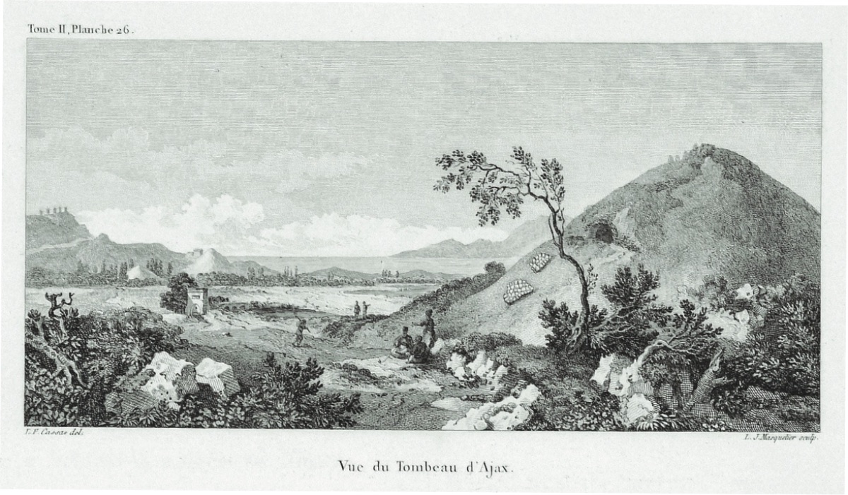
We were not lucky or successful in our efforts to search for the remains of Ophrynium, which some geographers marked between Dardanus and Rhoetium. I think this is more likely to be near the place where Ajax's tomb is located. Because some brick and pottery remains we found here are considered the most indisputable signs of the existence of an ancient settlement in the vicinity...
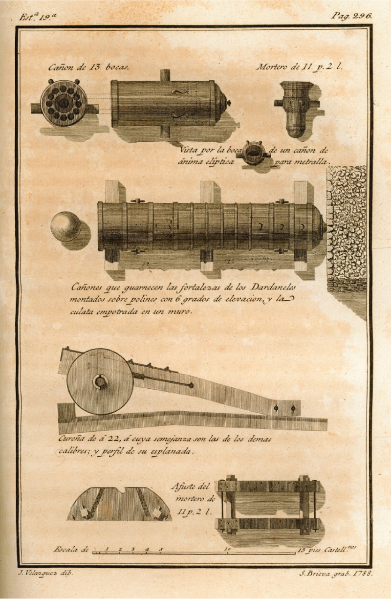
Cannons in the Fortresses of Çanakkale (1784, José Moreno) After passing Ajax's tomb, you will see a vast plain extending beyond Simois. The plain, sandy on the coast, presents an extraordinarily fertile landscape as it moves away from the sea. However, before crossing to Troy and touring these places made so famous by history, let's cross Hellespont again from Helle's bridge and go to the European side of Çanakkale to see those places.
About four miles beyond Sestos, along the coast, we encountered another bay. This was also a calm and sheltered place. But there was nothing as a building except a Dervish lodge. Inside the lodge lived five or six Muslim clerics.
Most foreign sailors do not even know this bay where the Dervish lodge is located. Because almost all of them anchor in front of Nagara. Because it is very close to both Maydos (Maiita) and Çanakkale. Ships make their food and drink supplies here.
On the opposite shore of Abydos, about half a league beyond Sestos, in a not very deep small bay, there is the village of Mayta. This village is built on the ruins of the ancient city of Madytos and closer to the sea. The remains of the ancient city are still present. A little further beyond Madytos, there is another small town called (Coelos Portus). This place witnessed the naval battles between the ancient Athenians and Macedonians, and at the end of these battles, the Athenians dominated Çanakkale (Hellespont). Bath Building in Alexandria Troas (1786, Jean-Baptiste Lechevalier)
The soil around Mayta is not considered very fertile, but still, small amounts of cotton, wheat, and fruit cultivation are seen. Most of the people are engaged in seafaring. Sails for ships are woven with cotton grown here and purchased from Çanakkale and Gelibolu.
Two leagues from Mayta, at the narrowest point of the strait, directly opposite Çanakkale, there is a small village. This is defined as the second European castle (fortress). The main castle is below the village and by the sea. Tournefort also drew a picture of this. But it is not considered very suitable for defense. It is very doubtful that they can be very effective against enemy ships with short-barreled, stone cannonballs filled with cumbersome cannons against ships trying to force the channel.
With these cannons, aiming as well as loading the enormous stone cannonballs is extraordinarily difficult...
The inhabitants of this village are mostly Turks. They take care of the maintenance and operation of the castle. They are engaged in seafaring to enable people to travel from one city to another on the channel. Greeks (Greeks) mostly work in agriculture. Here we saw beehives for the first time. The beehives that produce honey here are not kept in the open but in rather large buildings. Presumably, such a method is used to protect them from the cold in winter and the heat in summer. Who knows, maybe they took such a measure to protect these valuable creatures from humans, who could be more harmful than both cold and heat.
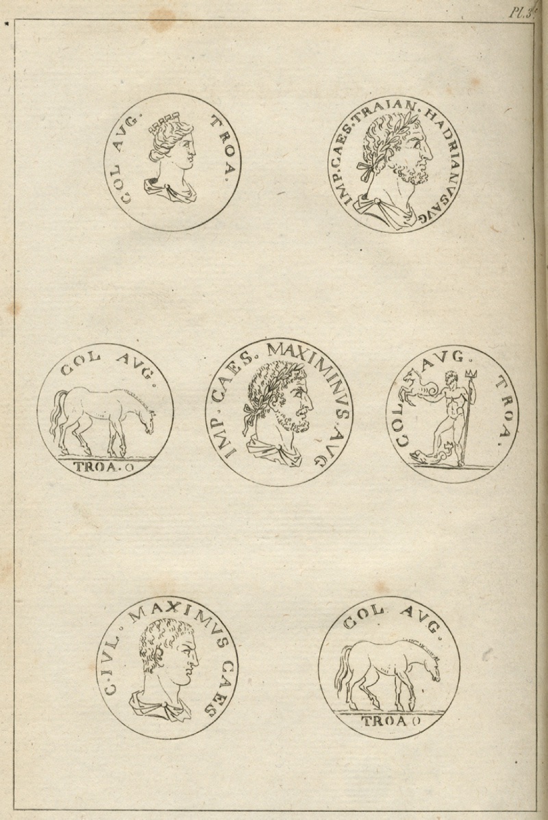
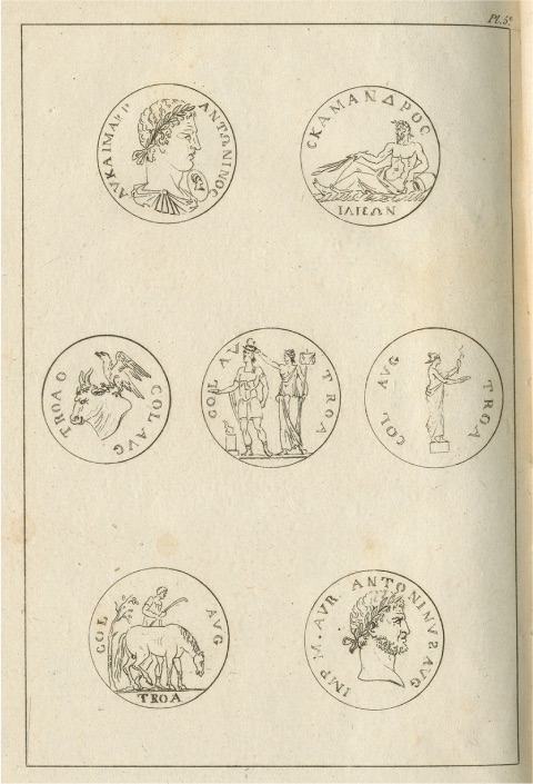
Examples of Coins Found in the Troas Region (1786, Jean-Baptiste Lechevalier)-2 Just a league below the second European castle, on a small hill, there is another dervish lodge. The duties of a few Turkish dervishes living here are to report the trade and warships entering the strait and to fly the Ottoman flag. There is almost nothing interesting to see in the area extending from here to the first European castle. There is only a sarcophagus placed on a rather high pedestal, believed to belong to Hecuba. At the entrance of the strait on the European side, the remains of water dams said to belong to the ancient city of Elaus are still visible. On these ruins, there is still a Turkish village defined as Seddülbahir Castle (Elbahar). Just below this, a European castle or fortress has been built. To the west of this castle, the tomb of Protesilas, King of Thessaly, who was killed by Hector, and the remains of a temple built in his name can be seen. Protesilas is the Greek hero who first set foot on the lands of Troy on the Asian shores, disregarding the prophecies of the gods that they would inevitably be killed.
From here, after a two-hour walk inland from the coast, we reached a Greek village called Alçıtepe (Critia). We have never seen red partridges so abundant anywhere else in this region. Rabbits were also plentiful and delicious. In the winter season, woodcock is very abundant in uncultivated and moist lands. The wild boars, which are also abundant here, were very tasty, probably because they were fed with grapes. But the most abundant four-legged creatures in the area are jackals. I think I will have plenty of opportunities to talk about this.
One day in the vicinity of Çanakkale, I watched the Greeks hunting partridges. These people set traps and hunted in masses as if they wanted to destroy their enemies who were attacking agricultural products rather than hunting a delicious creature for pleasure. Fortunately, the method of hunting partridges with traps is not applicable everywhere; it can only be applied in flat plains and cultivated lands.
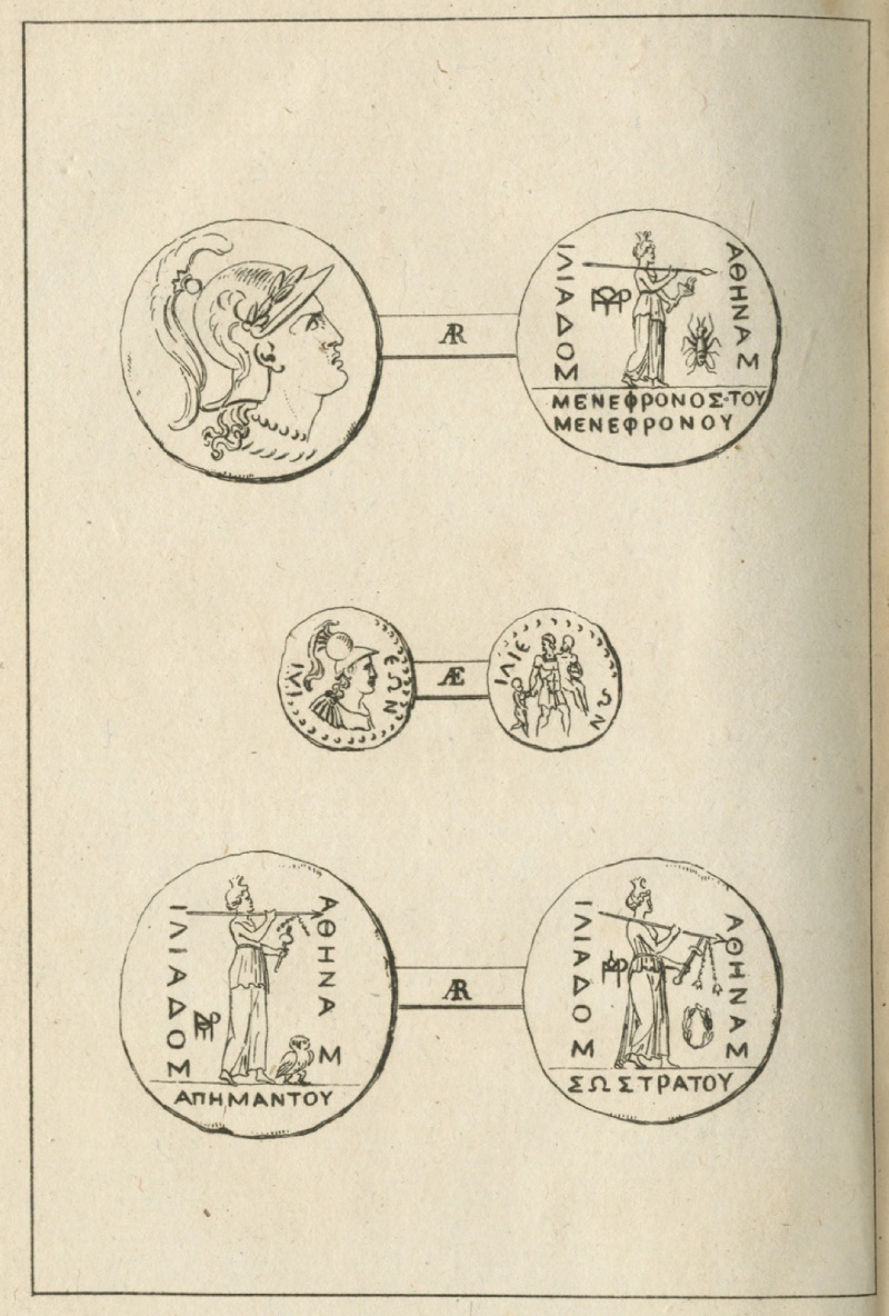
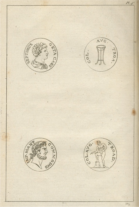
Many French, Italian, and English merchants have tried to establish trade centers in Çanakkale in the past. But none of them have been successful. Because they could not see the advantage of being close to the state centers, as the merchants who had settled in a large consumption center like Istanbul did. The people of Çanakkale and the islands, who constitute the consumption centers, saw it more sensible and profitable to supply their needs from Istanbul, which is nearby, through Jewish, Greek, and Armenian merchants, rather than obtaining them from afar. Moreover, they also had the advantage of benefiting from payment facilities in this way. Examples of Coins Found in the Troad Region (1786, Jean-Baptiste Lechevalier)
The export opportunities of the settled cities and villages in the Çanakkale region can be listed as follows:
Two to three hundred bales of various types of cotton,
A large amount of coarse woven cotton textiles,
Three to four hundred bales of low-quality wool and fleece,
An abundant amount of leather processed in Çanakkale and Gelibolu,
Three to four hundred quintals of oak gall,
A large amount of acorns,
Fifteen thousand rabbit skins,
80 quintals of cire (beeswax) and some licorice root...
A certain amount of wine is also sent from Mayta and Çanakkale to Istanbul. However, the local people mostly sell their wines to sailors who come to or pass through their ports. Sailors can easily buy fresh bread, biscuits, meat, chicken, eggs, fresh vegetables, and other provisions in Çanakkale.
A large amount of pottery is manufactured in Çanakkale. A very large part of these are sent to Istanbul. Despite the good quality of the soil and the production, we were very surprised that the decorations on them did not integrate properly with the main piece and that the paints faded over time, making the flowers and ornaments invisible.
...
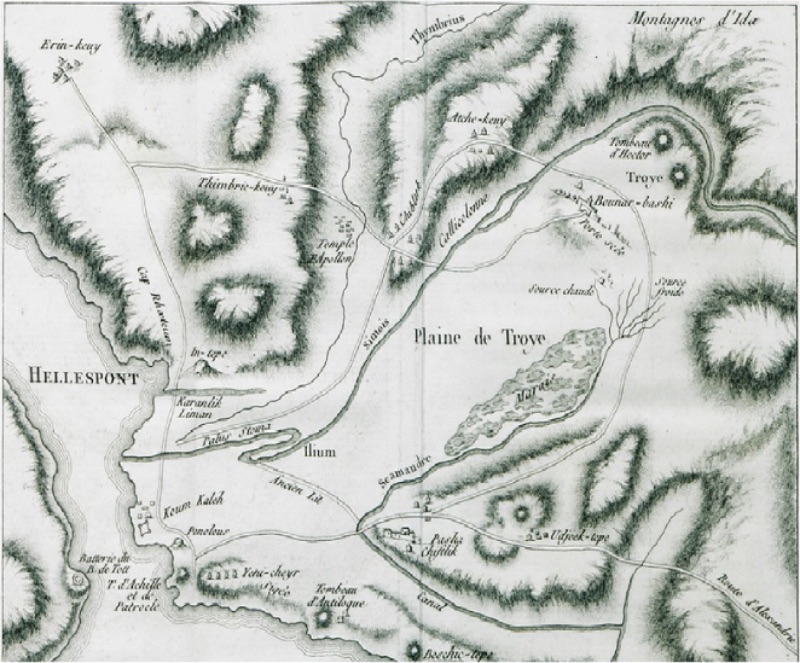
Examples of Coins Found in the Troas Region (1786, Jean-Baptiste Lechevalier) With a sounding device in one hand and our notebooks in the other, we walked step by step along both shores of the Dardanelles, measured their depths, and in many places went inland to record their conditions, the products they cultivated, along with our impressions. Now it was time to turn our eyes to the land of Troy, to examine these regions, which the war geniuses of the Greeks and Romans had made unforgettable. On the tenth day of the month of Pluvisoe (the fifth name of the Revolutionary calendar - from January 21 to February 20), we boarded a Turkish sailing ship from Çanakkale. With the help and effort of a cold wind blowing from the north, it took only two hours to reach the front of the 1st Asian fortress. When we landed, we went directly to a small Greek village at Siegee cape with our belongings, beds, quilts, and provisions. We thought we would be more comfortable here. Muslim Turks do not like foreigners wandering around, inspecting, or showing too much curiosity. In this respect, we would be able to make our observations more comfortably away from their suspicious glances.
This time, with citizen Lechevalier's map in one hand and Homer's Iliad in the other, we wandered around the surroundings of Troy, feeling deep pleasure and satisfaction in seeing how accurately the information conveyed in Homer's work matched reality.
The distance from Çanakkale to Kum Kalesi is about four leagues. From here, the distance to Sigee, where a settlement center called Yenişehir village is located, is only half a league. There are two tombs here. One is believed to belong to Achilles, and the other to Patroclus. This city, established on a sandy plain on the left bank of the Simois river, is neither as large nor as crowded as Çanakkale. Moreover, the air of this city, which falls behind the fortress, is not very healthy. Due to the swamp on the other bank of the river, it cannot be said to have a very comfortable climate because of the smell and flies in the summer months. Since the wind mostly blows from the north and northeast here, its air causes malaria.
A little beyond the swamp, there is a sandy bay. The Turks call this Karanlık Liman. According to legend, the Greeks who came to besiege Troy landed here...
If you walk for another half hour from here, you will come across a small village on the right side of the water. Near this place, called Halileli village, in the northeast direction, you will encounter the ruins of an ancient temple. This temple is said to belong to Apollo... Examples of Coins Found in the Troad Region (1786, Jean-Baptiste Lechevalier)
...
After leaving this village, we left Mount Ida and its foothills on our left and headed south. After walking for about two hours on rugged and uncultivated barren land, we came to another village called Akça Köy. The Simois river was flowing about a quarter of a league ahead. Here we encountered flocks of a type of sheep with large, broad tails. We talked to their shepherds...
Yenişehir Village, built on the ruins of Sigee, still preserves the remnants of the ancient city. When enthusiasts come here, they admire a large marble block about eight or nine feet tall erected at the door of a temple. The Greek inscriptions on it are almost completely erased...
On the other side of the temple door, there is a rather beautifully worked marble block with Bas Relief. In this relief, women holding swaddled babies in their hands are seen offering them to a seated woman. Although the French Ambassador to the Ottoman Empire at the time, Monsieur de Choiseul, had obtained the necessary permission from the Sultan to possess these two pieces, he was unable to do so due to the local people's obstructions and had to be content with having molds of this relief block made.
To the north of the village, there are about twelve windmills. These mostly serve as guides for sailors...
Ruins in Troy and Its Surroundings (1794, James Dallaway) When we wanted to walk towards the sources of the Scamandre river, we got stuck in swamps several times. We had a lot of difficulty getting out. For this reason, we left the riverbed and started to follow a separate path that would take us directly to Pınarbaşı. On our right, about a quarter of a league away, we came to a village called Boz Köy, where we suddenly encountered a spring gushing from under our feet...
I will not attempt to describe the beauties of the ancient city by looking at the current ruins of the city of Alexandria Troas. Because those who came here before us, the travelogues of Pococke, Wheler, Chandler, and Chevalier, have provided enough information on this subject. Let's just note the massive granite and Marmara marble columns we saw among the ruins. Many of these marble columns have been used in many mosques built in Istanbul by the Sultans. The First Detailed Map of Troy and Its Surroundings (1786, Jean-Baptiste Lechevalier)
To the south of the city, there is a small stream, and beyond it, there are two hot springs that the local Turks and Greeks do not use very wisely. Especially in the spring months, people flock to these hot springs from Troy and Bozcaada. Some hope to benefit from these waters for the treatment of an illness, while others hope to prevent a future ailment.
It is widely believed that these hot springs are particularly good for skin diseases, leprosy, and smallpox. The city's harbor is narrow and covered with sand brought by the waves of the Hellespont and the sea...
We set off from here in the afternoon, rowing into the harbor of Bozcaada. The distance to the nearest shore is about one and a half leagues (Geographer Strabon records this distance as 1375 feet). The distance from the city to the entrance of the Dardanelles is about five leagues. The harbor is quite small. It is not suitable for the entry of ships other than trade ships. There is a breakwater and a tongue-shaped landmass extending into the sea. A castle has been built here.
Ajax Tumulus Near Yeni Kumkale (1784, Aguste de Choiseul-Gouffier) Judging by its width and tax registers, it has a population of about five to six thousand. The number of Turks and Greeks living here is equal. Most are engaged in agriculture. A small part is seafarers. Most of the Turks work in the service of the castle.
On the island, there is a governor and a Janissary agha in charge of the castle's maintenance under his command. The number of Janissaries on the island is two to three hundred. They are responsible for the maintenance of the island. Venetian cannons without barrels still stand in the castle. As if they want to remind that these places belonged to Venetian merchants before the Turks came...
In Bozcaada, cereals and fruits are very scarce. Its only wealth is grapes. The people are engaged in viticulture. The vine likes the sandy, light, and deep soils of the plain. It also grows easily on slopes and fertile lands. The sticks are planted at regular intervals, varying according to the fertility of the soil...
The locals of the island add a quarter of water to the grapes they put in barrels. Despite this, they obtain quite high-quality wine with a fairly high alcohol content. If they hadn't told us in advance, we could easily have mistaken the Bozcaada wine we drank in some wealthy houses for an excellent Bordeaux wine...
Every year, five to six hundred thousand okkas of wine are exported from Bozcaada. Most of these wines are sent to Istanbul, Izmir, and Russia. In these countries, Bozcaada wine is preferred over others, especially Rhodes wine and Thasos wine. As a wine tax from Bozcaada, the Muhasillin receives more than 30,000 kuruş annually...
The locals here are not as cheerful as other islanders. Their entertainments are not very noisy or ostentatious. They are content to walk around the streets with serious, sullen faces. Who knows, maybe they are trying to avoid attracting the attention and thus the wrath of the Turks. However, when they do not see much danger around, they also go wild. Troy is very close to the coast. When there is a wedding or a festival, they go there and eat, drink, and dance under the plane trees until morning."