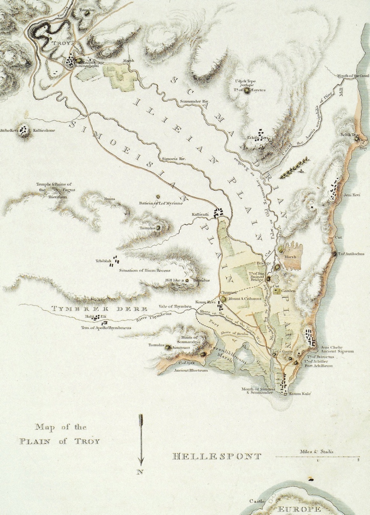
Troia and Its Surroundings Before Schliemann's Excavations (1801, William Gell) Born in 1822 in the town of Mecklenburg in Northern Germany, Schliemann took his first steps into the world of commerce as a small apprentice in Hamburg after a poor childhood. Later, Schliemann went to Amsterdam, one of the most important trade centers of the time, where he quickly succeeded due to his talent for foreign languages and went to Moscow as a representative of a large company. There, he soon amassed a great fortune by trading on his own behalf. During his years in Moscow, Schliemann married a Russian woman and had two children. With his marriage and outlook on life changing, Schliemann divorced his wife and dedicated his entire life to finding Homer's Troy. For this purpose, Schliemann visited the Çanakkale region for the first time in 1868, conducting a ten-day excavation at Ballıdağ near Pınarbaşı Village, which was believed to be Troy at the time, but he was disappointed. On his way back to Athens, his meeting with Frank Calvert, the youngest member of the Calvert family living in Çanakkale and serving as the British consul, changed the fate of both himself and Troy. With the help of Frank Calvert, who conducted small-scale excavations at Hisarlık Hill, believed to be Troy, in 1863 and 1865, Schliemann began his work at Troy in 1870. Shortly before starting his work at Troy, he married a young Greek girl named Sophia living in Athens. Schliemann's large-scale excavations began in 1871 and continued until he discovered and smuggled the Treasures of Troy in 1873. In 1875, a challenging court process took place in Athens between the Ottoman Empire and Schliemann. After long efforts, the Ottoman Empire realized it could not retrieve the treasures and reached an agreement with Schliemann, dropping the case in exchange for 50,000 gold francs. However, the relations between the Ottoman Empire and Schliemann were quite problematic after this case. Until his death in 1890, Schliemann conducted excavations intermittently. With his excavation methods and approach to the findings, Schliemann caused significant damage to the mound of Troy and its artifacts. In 1881, he conducted a detailed tour to prove that Hisarlık Hill/Troy was the largest and most important settlement in the region. He published his impressions of this tour as a book in the same year. This publication contains quite interesting information about the ethnic and cultural structure of the Çanakkale Region (Troas) in 1881:
"Journey from Çanakkale to Hisarlik.
I have visited Troas many times, spent months excavating there for five years, and yet I am still greatly delighted by every point of Troas geography, because every mountain, every valley, every river here, and the sea of the Dardanelles (Hellespont) breathe Homer and the Iliad. But this time, my trip to Troas has a very special purpose; because my aim is to determine which other remains besides Hisarlik are suitable for archaeological research.
I departed from the city of Çanakkale (Dardanelles) on May 13th, accompanied by a servant who owned the horses and two gendarme escorts kindly provided by the regional governor due to the area's lack of safety.
The temperature was 26.5 degrees when we left. As we rode out of the city, we crossed the small Çanakkale river, which flows even on hot summer days, and there is no doubt that this river is the Rhodios mentioned by Homer (Iliad, XII, 20); because this name has been in use since the time of Strabo, as he conveyed to us. Opposite the mouth of this river, on the Thracian peninsula, is the place known as the "bitch tumulus," accepted as the tomb of Hecuba, who, according to the epic, turned into a female dog after her death. Indeed, there is a small pointed hill at the place indicated by Strabo, but Frank Calvert, who investigated this place, determined that the hill is natural and only resembles a tumulus in shape.
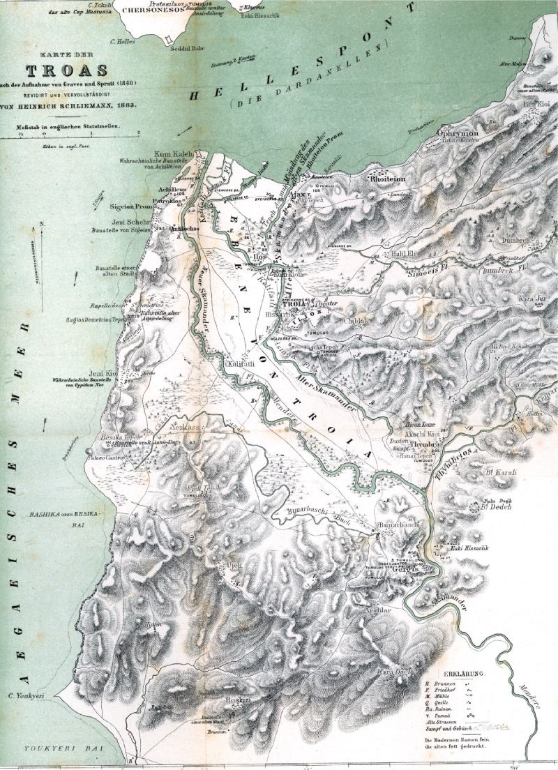
As we proceeded along the coast of the Dardanelles (Hellespont) on horseback, we passed by two tumuli, one on each side, which have not yet been investigated. From here, we passed to the right by a place resembling a hill, where the Aeolian city of Dardanos, mentioned many times by Strabo (XIII, 587, 590, 595, 600), was founded (but this should not be confused with the Dardania mentioned by Homer (Iliad XX, 216)). As Strabo conveyed to us (XIII, 595), Cornelius Syla and Emperor VI. Mithridates came here to make a peace treaty. The excavations conducted here at my insistence, by the military governor of Dardanelles (Çanakkale), showed that the soil remains here are only 60 to 90 cm thick and consist almost entirely of humus soil, so there is nothing to be found here in terms of ancient sciences. Troy and Its Surroundings During the Schliemann Excavations (1874, Heinrich Schliemann)
After this, we passed a rise on our left, where there is an uninvestigated tumulus, and came to the place accepted by Calvert as the city of Ophryneion, but also marked with the same name on Spratt's map as the remains of an ancient city. However, the remains here only manifest as some Hellenistic pottery and some stone piles; there are no ruins or wall remains here. At the same time, this place does not match the information Strabo gave us about Ophryneion (XIII, 595), stating that Ophryneion was near the Pteleos swamp or lake. Such a place is about half a mile away from here, near the ancient city of Palaecastron. The reason I accept this place as Ophryneion is that it is full of Hellenistic pottery, but the soil remains here are also less than 90 cm. Later, according to my barometer, we reached Ren Kioi (Erenkoy), which is 188.2 meters above sea level, with a temperature of 23 degrees (meaning colorful village).
From here, on our way to Hisarlık, we crossed the Ren Kioi stream, which is not fed by a spring and only flows after heavy rain, otherwise remaining dry. To prove the impossible theory that "Old Troy is not located in the Dümrek valley," Brentano (Ilion im Dumbrekthale, Stuttgart 1881) equates this stream with Simoeis and incorrectly marks it on his map. The course of this rain stream is placed entirely correctly on both Spratt's and Virchow's maps (Beitraege zur Landeskunde der Troas, Berlin 1880). I spent the night in one of my houses at Hisarlık (Troy); in my observations here, I was pleased to see that the channels opened for rainwater flow in my excavation pits, which I left in June 1879, were exactly as I intended and that there were no changes in the pits.
I was surprised to see that all the walls of my houses were covered with something black up to the roofs. Since I arrived at night, I couldn't immediately understand what they were. In the morning, I realized that these were locusts, which were much more numerous in Troas this year than in previous years and caused great damage to grain fields and pastures. However, despite this, I did not see a grain field completely ravaged by them, because the locusts do not eat more than half or a third of the greenery in a field, they only eat the leaves, not touching the ears. They prefer greenery over the ears; because throughout my journey, I did not see them leaving a single piece of greenery behind in the large areas I passed.
On May 14th, at 8 o'clock, the temperature at Hisarlık was 17.2 degrees.
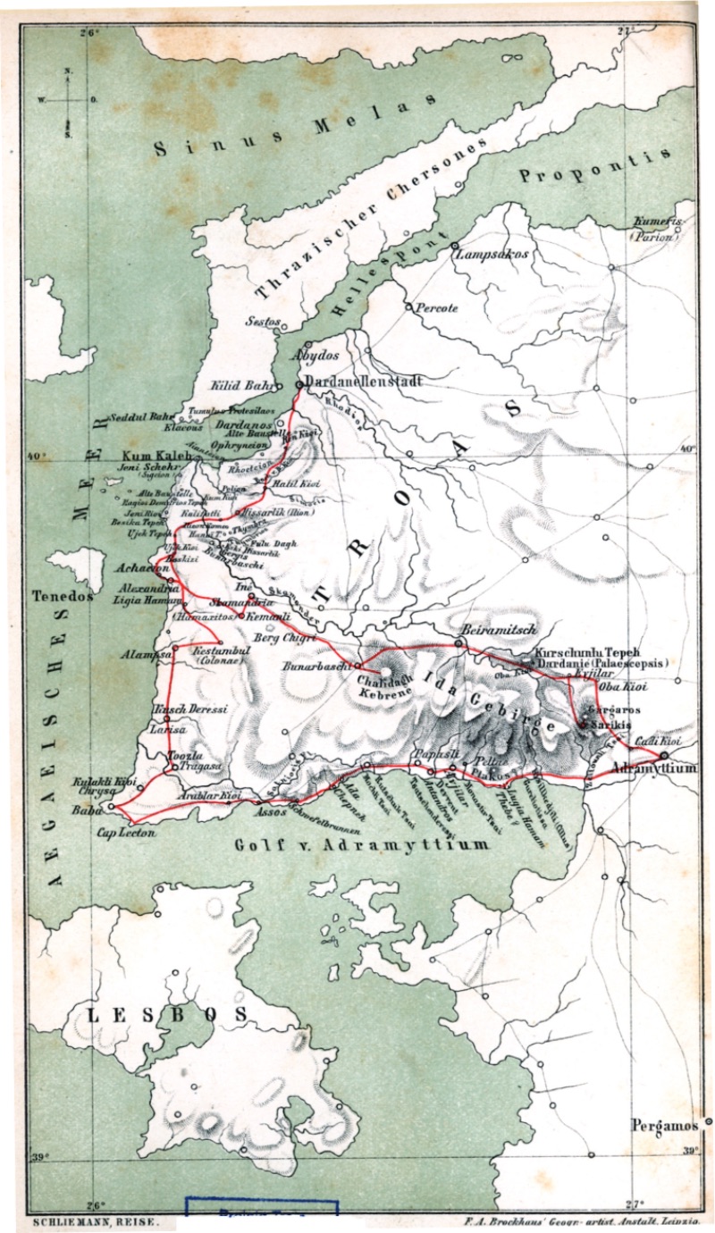
Route of Schliemann's 1882 Troas Journey (1882, Heinrich Schliemann) From Hisarlık to Kestambul
We followed the road through Kalafat to the village of Üvecik (Ujek Kioi); my barometer showed that the second place was 86.6 meters above sea level; the temperature was 18 degrees. The Karamenderes River (Scamander) was 60 cm deep when we crossed it this time. In all Turkish villages of Troas, as in Ujek Kioi; there are many stork nests, which are never seen in the Greek villages like Kalafatlı, Yeni Kioi (Yeniköy), Yeni Sherhr (Yenişehir). Because storks are almost sacred to the Turks; the Greeks call them "the sacred bird of the Turks" and do not allow them to build their nests on their houses. One of the commendable characteristics of the Turks, which I will state without any doubt, is to welcome a thirsty traveler and his horse with good, drinkable water... Indeed, no village is too small or too poor to have a fountain surrounded by a magnificent wall, with water flowing from its fountain into a four-cornered trough from both sides, where animals line up to drink. All roads are equipped with this and similar fountains, with a jug or a container made of wood or zinc, chained to the fountain for the thirsty to drink easily. On top of most of these fountains, especially the richer village fountains, there is a long inscription with quotes from the Quran, the name of the person who funded the fountain, and the date it was built. If such a fountain is inside or near an ancient settlement, then many marble statue pieces can be seen on the walls of the fountain.
Another very good characteristic of the Turks is their respect for the dead: because here, unlike the barbaric traditions of Europe and America, there is no tradition of leaving the dead in peace for only a year if the money for the tombstone is not continued to be paid. On the contrary; in Turkey, graves are considered sacred ground; they are never touched. Therefore, there are many large cemeteries here; the graves of the wealthy are adorned with two standing white marbles, the smaller one at the foot, and the larger one at the head of the grave, placed in the form of a turban at the head of the deceased. This last stone is usually painted blue or green, and the stone is adorned with a long inscription with religious content, the name of the deceased, and the date of the grave. These inscriptions are generally gold-plated. On the graves of the poor, there are two similar, unpolished ordinary stones without inscriptions.
Wherever a Turkish grave is near the remains of an ancient city, the graves of the poor are adorned with column bases and marble pieces. For example, all the Turkish graves in the plain of Troy are adorned with marble columns and pieces brought from Novum Ilium (Troy). Next to all Turkish cemeteries, there are two vertical, polished stone blocks placed like a table on top of them. With very few exceptions, these large stone blocks are taken from a ruin and have two vertical white marble columns underneath. In family graves, the coffin of the deceased is placed on this stone table, and prayers are said in front of it.
From the village of Üvecik, we continued our journey on horseback through a narrow road passing among junipers, oaks, and pines growing at higher altitudes, reaching the village of Boskızı (Bozköy?) (46.8 meters above sea level) where the oak forest begins in 55 minutes. In this small and poor village, stone blocks from ancient structures are seen; some of these blocks are so large that they seem very difficult to have been brought from afar. For example, we see very large granite blocks on the steps of the mosque, one of which is drilled to be used as a door hinge. At the main entrance of the same structure, there are four columns, two of which are granite and taken from an ancient structure. One of the wooden columns is placed on an Ionic capital, and the other on a Corinthian capital. On a second staircase, there is a white marble used as a door threshold and other blocks taken from ancient structures. In the surrounding wall here, we see one column made of white marble and another of granite; in the distance, we see a granite column base on the terrace of two Turkish houses. We think all these ancient stone remains were brought from the ruins of an ancient city we saw on the roadside 1000 steps south of the village of Bozkızı (Bozköy). However, we cannot identify this place with any city mentioned in the classics of Troas. On the roadside, we see granite columns standing alone, belonging to an ancient settlement covered with old pottery, but the depth of the remains here is not much, only a few fingers deep. After Bozkızı, we reached the village of Geyikli, which is only 32.5 meters above sea level, in 50 minutes. Here, too, there are many granite columns and a few pieces of marble statue fragments; since there are no ruins of an ancient settlement in or near Geyikli, these remains seem to have been brought from Alexandria Troas. The road continues through partially cultivated but mostly covered with Aleppo pine land to the hot springs named Ligia Hamam (Kestanbol baths) located in a magnificent valley about a quarter mile southeast of Alexandria Troas. Here, there is a women's and a men's bath. The former is dome-shaped, resembling a mosque, with stones taken from ancient structures seen on its walls. In the middle of it, there is a rectangular pool surrounded by walls, 3.90 m long, with a hot spring of 53 ½ degrees coming out of the rock, but the water temperature in the pool is 34 degrees. A headless, decorated, white marble statue of a woman is placed on the surrounding wall of this bath. About 39 meters southwest of this spring, there is another spring where the water coming out of the rock is so hot that the mercury in the thermometer showed 60 degrees in a few seconds, so I couldn't measure the temperature of the water. This spring flows into the men's bath. There are three very dirty small windowless rooms made for patients to stay in. In these cage-like rooms, without even a stone bench, patients have to lie on uneven stone floors. There are also many small springs coming out of the rock crevices on the north side of the valley. The water from all the hot springs combines at the bottom of the valley to form a small stream; horses afraid of the hot water cannot cross this stream. The water in the springs is invariably salty and contains iron oxide and is very beneficial in curing rheumatic pains and skin diseases. Yes, if there were the necessary facilities and a good doctor here to explain to patients how to use the water, these hot springs could perhaps become the most famous in the world. Now, however, there is no maintenance here, and I found no living creature other than a crow and a cuckoo breaking the deathly silence of the valley with their cries.
Whatever the case, it looked entirely different in ancient times; because the slopes on both sides of the valley, especially the northern one, are filled with building remains that stand as silent witnesses to the fact that there was once an important city here. Among these remains, the quite large remains of Roman period baths particularly attract our attention. Around the bath structures, we see graves recently made with the sole purpose of using the marble plaques that covered the buildings. The walls of these bath structures were made of small stones joined with lime or mortar, sometimes using large granite blocks in between, but the interiors of the actual baths were made of large cut blocks forming cathedral-like domes made of lime or mortar. There are many niches used for offerings on the walls. Some bath structures probably had a forecourt made entirely of columns; because there are many granite columns and also fluted marble columns almost all buried among the remains. There are also remains of bath structures and houses that at first glance seem to belong to the Middle Ages. Therefore, we can assume that the city was abandoned at the end of the Middle Ages. Since the city was built on mountain slopes, the pile of remains is not very large, but in some places, it is close to 2 meters. The height of Ligia Hamam (Kestanbol baths) above sea level is 23.2 m, and the temperature is 21.5 degrees.
At 5:28 PM, we arrive at Kestanbul (Dalyan), which is 185.4 meters above sea level, with a temperature of 18 degrees. Turks live in this village, so there are many stork nests here, often even two on one roof. We see that many marble pieces belonging to statues and column bases are used in the walls of the houses. The most beautiful place in Kestanbul was a small square tower-shaped fountain in the shade of magnificent plane trees, with taps on three sides and a lead cup chained to it. On the marble panel above the work, which has a flower pattern on each face, measuring 0.43 meters long and 0.70 meters wide, there are quotes from the Quran, the name of the sponsor, and the date of construction, the year 1193 Hijri. Since the current year is 1298 Hijri, this fountain is 105 years old.
In this village's other fountain, an old, large basalt sarcophagus was used. On the upper corner of the sarcophagus, the following inscription is found:
P O S T V M I A V E N E R I A
Below the inscription, there is a rose ornament and a wreath of flowers with two human figures; a tree figure with a bird on their heads. This artifact and inscription seem to belong to the Middle Ages. On the right, there is another marble block with geometric patterns, probably older. The high position of this village, the many ancient remains used in the house walls, the numerous old pottery seen in the gardens and fields, but especially the very large granite blocks, mostly in the form of a monument; all these convince me that Kestanbul is the site of the ancient city of Colonae. Its location matches exactly with the information given by Strabo (XIII, 589, 604), such as being near Achaeium next to Alexandreia and 140 Stadia away from Ilium. The name Colonae must have been taken from the many and very large, gigantic gravestone-like granite blocks in the surrounding fields. There are 110 Turkish houses in Kestanbul.
From Kestanbul to Baba
Our journey continues to Alemşah, which was the scene of a tragic event in 1880. In this village lived a merchant named Uzun Hacı, known to have 30,000 coins, with only a 25-year-old son. 20 Greek bandits, arriving at the shore with a large boat on a Friday during the month of Ramadan in September, went to Alemşah, half an hour away. Knowing that Uzun Hacı was at the mosque during prayer time, they raided his house, kidnapped his son, and demanded a large ransom. The bandits fired at two guards who resisted, wounding one. Due to the gunshots, the whole village heard the incident, and fearing that the Turks would pursue them, the bandits killed Uzun Hacı's son, for whom he would give all his wealth, and the two guards, and fled. A similar clash, where two workers and two bandits were killed, also occurred in 1879 in the village of Kalafatlı, 20 minutes away from Hisarlık.
On the half-hour road from Kestanbul to Alemşah, we saw new granite columns lying horizontally on the ground, 1.35 meters in diameter and 11.40 meters long. This place is covered with beautiful valonia oaks. We passed to the village of Tavaklı, 239 meters above sea level (temperature 18 degrees), and reached the large village of Kush Deressi (Kösederesi), meaning "Bird Stream," four hours away from Kestanbul. It is located an hour from the sea, on the edge of a small stream, 56.3 meters above sea level, and consists of 200 houses. Of these, 190 belong to Turks, and 10 to Greeks. The thickness of the remains here is about 2-3 meters, and many marble blocks from ancient structures are used in house and garden walls as well as in bridges over the stream. In addition, many coins from the Hellenistic and Roman Periods and the Middle Ages are found here. I bought a beautiful bronze coin belonging to Assos here.
There is no doubt that an important city existed here, which I believe can only be Larisa. According to Homer (Iliad II, 840-841), this place was inhabited by the Pelasgians, allies of the Trojans. Its location fully matches the information given by Strabo (XIII, 604), stating that Larisa was near Achaeium and later Chrysa. The Turkish cemetery in Kush Deressi (Kösedere) is the largest I have seen so far; about 1000 meters long, 200 meters wide, and like most Turkish cemeteries, filled with cypress trees. Especially at the front, there is a high wall containing many pieces of architectural marble blocks. The stairs are almost entirely made of marble blocks from ancient structures; the following inscription, now quite worn, is seen on it:
ΦEPMO
BPAΠOY
OMHPOY
From here, we reach the hot salty water springs just north of Toozla (Tuzla) in an hour and a half, the first of which may have around 40 springs. In the first spring I measured, the thermometer showed 60 degrees, and in the second, 40 degrees. I couldn't measure the other two as the thermometer rose above 62.5 degrees in a few seconds. The rocks from which the salty water springs emerge are dirty red, yellow, or white in color; in this respect, they are very similar to the rocks at the Dead Sea.
Here, there is only boiling salty water, in which a hedgehog was completely boiled. It is seen that these springs rise from the rock to a height of about 18 meters; however, most are insignificant springs dripping drop by drop. A small salty water spring gushes from the ground at the foot of the rocks. Primarily, these springs are salt springs, but I saw no one dealing with them. From here, we reached the village of Tuzla (Toozla), consisting of 30 houses, located in a rocky valley, with hot salty water springs on both sides, where the temperature in the shade is 25 degrees (64.6 meters above sea level). At the end of the rocky valley, there are very rich boiling salty water springs rising to a height of 0.40 meters with great pressure from the flat rock.
In Tuzla (Toozla), there are many granite columns witnessing the former significance and splendor of the city Tragas or Tragasae, mentioned by Strabo (XIII, 605) as being near the salt springs. In the walls and stairs of the mosque, which was once a Byzantine church, there are large, decorated, and polished marble blocks. One stork nest is on the dome, the second on the single minaret, and the nest on the minaret is so close to the gallery (balcony) that the dervish has to lean to avoid disturbing the stork or damaging the nest while calling to prayer; the third nest is on the cypress tree next to it.
Tuzla (Toozla) is two hours from the sea. 1.5 English miles south of this village, saltwater springs emerge from the dirty, yellow, or white rocks inside and above the valley. 15 minutes from Tuzla, we cross the Tuzla Stream (Satnioeis stream), mentioned by Homer (Iliad XXI, 87) as being near the city of Pedasos, inhabited by the Leleges. However, it is known that the remains of this city were already buried under the alluvium of the river in Strabo's time (XIII, 605).
After climbing the heights on the south side of the Tuzla Valley (Satnios valley) for two hours, we reached Kulakli Kioi (Gülpınar), near the place that can be accepted as the remains of the city of Chrysa mentioned by Homer. The highest point of this village is 147.9 meters, and the temperature is 20 degrees. At the foot of the elevation, there are beautiful gardens with the foundations of the Apollo Smintheus temple, made of white marble in the Ionian style, ocktastyl and pesudodipteral plan, excavated by Pullan in 1866 with the help of the Dilettanti Society in London. Some columns, capitals, and beams stand in the gardens; there are also some very special architectural marble pieces that look like parts of a large candlestick. Strabo (XIII, 604) mentions an Apollo statue made of the banewort (skopa) tree, with a mouse under its foot. The columns were 11.1 meters long, and the column base was 1.12 meters in diameter. The foundations of the temple are 34.8 meters long, 29.4 meters wide, and 27.1 meters above sea level. The threshold on the road to the temple is 2.57 meters long, 1.5 meters wide, and a second threshold of similar size is seen a little higher. We see much larger basalt blocks, seemingly belonging to another structure, in the nearby garden walls.
From Kulakli (Gülpınar) Kioi to Baba (Babakale), the small path continues through rocky areas with junipers, oak bushes, and spruce trees (three hours). Baba Village (Babakale), established on the western extension of Lekton Cape, known as Baba Burnu, is a modern village of 150 houses inhabited only by Turks. It was probably founded 157 years ago; because the oldest date given above the castle gate is the year 1140 Hijri. The height of the castle bastions measured by me is 38 meters above sea level, and the temperature is 16 degrees. There was never an ancient city settlement here. From here, there is a beautiful view of the island of Lesbos (Midilli) to the south and Bozcaada (Tenedos) to the north. When the wind is good, it takes 1.5 hours to reach the island of Lesbos (Midilli) from here.
From Baba to Assos
From here, on May 16th at 5:30, we continued our journey on a zigzag narrow road, on the rocky slope where the village settlement is located, and then on the road going through all the mountain ridges made of volcanic rocks to Assos. It takes 1.5 hours to reach the summit at 274 meters high. But even this height cannot be the real Lekton Cape, because there are much higher points to the east. I needed an hour and ten minutes to reach another summit, almost vertical, at 355.7 meters above sea level, with a temperature of 19 degrees. Whatever the case, Homer could only have described Hera and Hypnos going from this cape to Ida from this point (Iliad, XIV, 284-285):
They arrived at the many-fountained Ida, mother of beasts
They sprang from the sea at Lektos
They set foot on the fertile soil.
The forested peaks trembled beneath their feet
(Turkish translation: A. Erhat- A.Kadir)
I am convinced that the information given by Strabo (XIII, 605): "According to the epic, Agamemnon had altars built for 12 gods at Lekton cape" can only apply to this highest summit. And indeed, I found the remains of an ancient structure made of a solid wall of stones of various sizes, put together without lime or mortar, measuring 5.5 meters long and 4.5 meters wide. The current height of the monument above the surface is only 0.45 meters, but its true height can only be determined by excavation. However, it does not seem to be very high. There is no doubt that these remains are the altars of the 12 gods attributed to Agamemnon. However, I do not believe that these were built by this hero himself, because even the number 12 shows that this would not be the case. At the same time, I do not believe that this monument could be very old. Because there is no prehistoric pottery here, but among the stones, there are pieces of mostly polished red Hellenistic vases that cannot be older than the Macedonian period. Here, I would like to add that this is the only structure between Chrysa (Kulakli Kioi/Gülpınar), Baba (Babakale), and Assos, and there are no traces of past human settlements in the entire region. The altar of the 12 gods is located in the middle of a rise made of large stones, 0.90-1.5 meters high, joined without mortar; however, I warn travelers coming here not to see these or the four similar walled enclosures nearby as old walls or remains related to the temple of the 12 gods in any way. In reality, these enclosed areas are nothing but walls belonging to very newly built sheepfolds; a similar sheepfold can be seen 15 minutes to the north, and I encountered such sheepfolds all the way to Assos.
Next to the altars of the 12 gods, there is a well made of stones of various sizes without mortar, and since there is no marble in this region and the shepherds are poor and have no desire to bring such a thing from afar when they have volcanic rock at hand, there is no doubt that it is old, covered with a polished large marble block. We continued our journey through the village of Paidenli (Bademli) (278.4 meters above sea level) and the village of Koyunevei (286.1 meters above sea level, temperature 22 degrees). The volcanic rocks covered with volcanic ash here are covered with shrubs and rare pine trees. Even in this barren region, it has been invaded by swarms of locusts that have left neither grass nor a plant for the herds to eat. Generally, millions of them can be seen moving from a fertile seed field to a grassy area, and after destroying the last field, they return.
However, wherever one looks, the scenery is beautiful, because everywhere there are very large volcanic rocks resembling huge walls, standing alone or generally in clusters of three, five, and ten. Sometimes these blocks can be seen stacked vertically like a large church organ. Sometimes they can be seen tightly lined up in a long row like a tower. The beauty of the scenery is further enhanced by the ever-present sea, usually also seeing the Aegean Sea and the Gulf of Edremit.
After passing the village of Arablar, at 277 meters high, we arrive at Assos, now called Behram, at 4 PM, with an elevation of 232.7 meters and a temperature of 19 degrees. At the highest point, it is clear from the remains that there may have been two or three temples here, and it is being excavated by the Boston Archaeological Institute. Nevertheless, in my opinion, the depth of the remains here is no more than 3 steps, and therefore there is no hope of finding valuable statues here. To the north, there is a special structure resembling a Byzantine church converted into a mosque, with a low dome and four corners. Next to it are two four-cornered towers, one of which is half destroyed; the second is very well preserved, measuring 20 meters long and 12 meters wide according to its battlements. Both are made of cut stones joined with lime and seem to belong to the Middle Ages. Nearby, there is a semicircular dome, probably a cistern, and all the large walls with battlements seem to belong to the Middle Ages. The main structure of the ancient city must have been located on the two large terraces on the south and sea sides. The walls, covered with cut large granite blocks and trachytes, were built to take advantage of their natural positions, and the upper terrace must have housed the old agora; however, the pile of remains is also quite insignificant due to the transportation of stones from Assos to the palaces and mosques in Istanbul (Constantinople) for centuries. On the east side, the remains of a small structure accepted as a sacred fountain (Nymphaeum) are seen. On the second terrace, there are remains of many large structures; perhaps the work of the Boston Archaeological Institute here may be rewarded with some beautiful statues. Such hope is greater in the large theater seen when looking down from the second terrace; because even though all the marble blocks of this monument have been stolen, the pile of remains here is more than in other parts of Assos. The walls built of large cut granite blocks and trachytes are better preserved than those of any other Hellenistic city and offer us a complete ancient defense system that has survived to this day. The walls were built to take advantage of their natural positions and divided the acropolis and the city with many towers, only one of which is four-cornered. Their average thickness is 2.5 meters, and they are made of stones cut into wedge shapes or four-cornered blocks. The stones were laid in the same way as the large ancient castle walls in Alexandria Troas and Çığrı Mountain. That is, the inner sides of the walls and the spaces between the wedge-shaped blocks were filled with small stones. Wherever the walls were made of four-cornered blocks, the walls were regularly cut with wedge-shaped blocks; thus, they could be positioned more securely in place. All the stones bear clear marks of being shaped with an iron chisel, allowing them to remain solid for centuries. In my opinion, the entire western wall belongs to the Roman Period, while the rest is probably not older than the Macedonian Period. However, in two places, new walls made of polygonal blocks, which could be very old, have been built on top of the walls; these are generally called Cyclopean walls. Nevertheless, if it is claimed that they are very old, I will object to calling these walls Cyclopean, because only the outer side of the blocks is polygonal; the rest is entirely built in the same way as the blocks in other walls. That is, the spaces between the wedge-shaped blocks and the inner part of the wall are filled with small stones. Therefore, these walls have nothing in common with Cyclopean walls made of polygonal blocks; perhaps only the outer appearance resembles them. We have no other example of such a style of wall craftsmanship, and besides, all their outer surfaces have marks carved with an iron chisel. Therefore, these walls cannot be older than the 5th or 6th century BC. It is also quite interesting that the polygonal walls are curved or inclined.
The very well-preserved, paved streets made of cut stones of various sizes are quite interesting. Such a street descends eastward from the acropolis and proceeds towards the elevated tower, whose outer walls are made of cut four-cornered blocks measuring 1.80 m long, 0.39 m wide, and 0.45 m deep. From this point, there is a magnificent view towards the Tuzla Stream valley (Satnioes) and the volcanic rocks covered with shrubs and spruce pines. Since the old street can be seen everywhere without any remains on it, I think it would be easy to excavate here due to the small pile of remains. But again, for this reason, I think very interesting things may not be found. In the gardens to the west and east, which I drew the attention of the very good American experts sent by the Boston Archaeological Institute to Assos, with whom I had the chance to meet, there may be something.
We know very little or nothing about the history of Assos. Although Strabo says it was a colony of Methymna from Lesbos, the magnificent position of the city overlooking the sea gives us the belief that there must have been a settlement here from much earlier times. I suspect that Assos is the ancient Chrysa, often mentioned in the Iliad, with its famous Apollo Smintheus temple. I even suspect more; according to the Iliad (I, 431), ancient Chrysa had a harbor; Strabo (XIII, 612) describes it as a unique harbor on the entire northern coast from the Gulf of Adramytteion (Edremit) to Assos. According to Strabo (XIII, 612), the cult of Smintheus Apollo moved from the old Chrysa to the new Chrysa we mentioned earlier. All we know about Assos is that after the region came under Persian rule, the city had to send wheat to the Persian king. According to Strabo (XIII, 610), Assos gained its freedom in 350 BC during the reign of the eunuch Hermeias, who invited the philosopher Xenocrates and Aristotle to the city and married Aristotle to his niece. However, the city soon came under Persian rule again after Hermeias was killed. After the death of Alexander the Great, the city was made part of the empire by Lysimachus and later handed over to the king of Pergamon, and after the death of Attalos (130 BC), Assos came under the rule of the Roman Empire. Assos was also visited by the apostles Paul and Luke (Acts 20, 13, 14)."