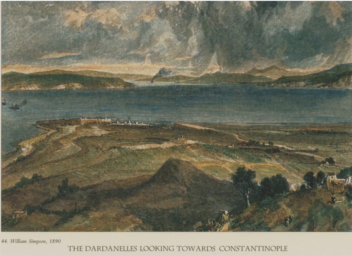
Old Kumkale and the Tumulus of Achilles from Orhaniye Fortifications (1890, William Simpson) Lucy Mary Jane Garnett, an English linguist, folklorist, and ethnologist. She traveled for eight years in Izmir, Istanbul, and Thessaloniki in the late 19th century. During this period, she wrote many books based on her observations and research on Turkish culture and people. The most important works of the author, who lived between 1849-1934, regarding the Ottoman Empire and Turkey are: Ottoman Wonder Tales, Turkish Life in Town and Country, Home Life in Turkey, Mysticism and Magic in Turkey, and Turkey of the Ottomans. Although it is not specified exactly when Garnett visited the Çanakkale region, it is understood from her accounts that it was in the mid-1890s.
"Despite the rich natural beauty of the Dardanelles and its surroundings, the interest shown here is particularly due to its location and the historical events associated with the ports and shores here. On the Asian shore, at least every promontory, every bay on the coast, has been identified as perhaps the site of an ancient city or a place where a mythological event occurred. The larger of the two peninsulas separated by the strait is the westernmost point of Asia and encompasses the entire "Immortal Troy Epic"...
On the other shore, the cape of Beşik Bay, which we mentioned above, makes a shallow turn extending to Kum Burna. This name will sound familiar to Western ears as the place where British and French ships anchored in 1853 and due to the significance of the same ships in the last crisis of the Eastern Question.
Directly opposite here is the harbor of the island of Bozcaada (Tenedos); as Vergil describes (de statio male fida carinis - not a very safe harbor for ships), steep, rocky, and on the other sides of the coast, it is impossible to land. The small harbor is both beautiful and very interesting. The town, which houses three thousand people, mostly Turks and Greeks, rises towards the upper parts of the hill and is crowned with a fortress surrounded by solid walls with towers on the inside. On the southern hilly slope, there are windmills in a row; a small tower controls the entrances to the harbor. One or two simply painted sailboats are moored to the harbor, loading barrels of Tenedos muscat wine, famous for its taste in the East.
...
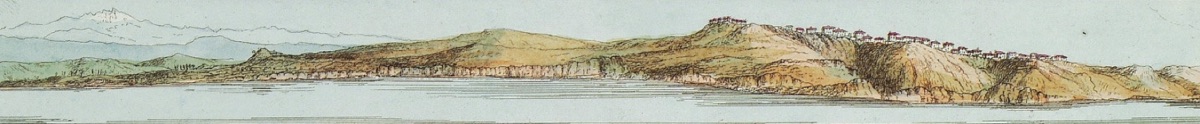
Yenişehir Village on the Anatolian Side at the Entrance of the Dardanelles (1801, William Gell)
Beyond Bozcaada (Tenedos), the rocky and steep cliffs of the Troas coast are visible. The small plateau, with tumuli on it and named Troy Cape by local sailors, is located directly opposite "Rabbit Island"; it is identified with ancient Agamias by M. Choiseul-Gouffier. It is said that this place, meaning "Unmarried," was made for the young girls of Troy left on the shore for the sea monster sent by Poseidon to punish Laomedon, who did not keep his promise. When it was the turn of the king's daughter, Hesione, Herakles, returning from a campaign against the Amazons, promised to save the young girls if Laomedon gave him the horse that Tros once received from Zeus in exchange for Ganymede. The king promised, but again did not keep his word; upon this, he organized a campaign against Troy with six sailing ships and destroyed Laomedon and all his children except Priam.
However, according to some writers, this sea monster is actually a pirate named Keton, to whom the Trojans paid ransom for their young girls. The steep cliff (Propognaculum Herculis) seen to the north among the rocks is thought to be the shore where Herakles landed and where the Trojans met the pirate. Before reaching this cliff, we passed Yeniköy (Yenikeui), built on a plateau 203 feet high above the sea. Beyond these steep rocks, there are many elevations and windmills scattered along the village towards Yeni Şehir. Among them, the St. Dimitri chapel, built on the ancient temple of Demeter and using some of its marble pieces, rises. In the East, it is common for pagan altars to be dedicated to Christian saints with phonetically similar names by churches. A depiction of Apollo becomes St. Elias, Parthenos becomes the Virgin Mary, and so on.
Yeni Shehir (Yeni Şehir) is built on the ancient city of Siegeum. However, instead of the fortress, many windmills have been built, and a Christian church has been constructed on the remains of the Temple of Athena, whose remaining parts are scattered around. The ancient city is said to have been built largely with stones brought from the temples, towers, and defensive walls of Ilium (Troy) and erected by the ruler who stood at Siegeum. From this point, there is a magnificent view as far as the eye can see. To the east, the Homeric plain, to the west, the Aegean Sea and islands, the enchanting sunrise throughout the region, and to the west, the sunset can be seen. Behind Gökçeada (Imbros) is Semadirek (Samothrake), with its peak where Poseidon sat and watched the battles in front of the city of Troy; if the weather is clear, the sacred Mount Athos, more than a hundred miles away, can also be seen. To the north, the entrance to the blue Dardanelles (Hellespont) borders the Thracian Peninsula, where the city of Asarlık (Eleus/Abide Tepesi) is located. In addition to the mythological, natural, and historical significance of this point, it is said that this is the place where Herakles and the Greeks under the command of Agamemnon attacked Troy, along with many heroes.
...
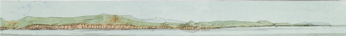
Gelibolu Coast of the Dardanelles (1801, William Gell)
The plain of Troy is perhaps more beautiful than the surrounding region with its fertile soil and magnificent view, and we went on horseback to Dr. Schliemann's very beautiful excavation, through the red, yellow, and white flowers among the grasses in the meadows on one side and the cornfields on the other...
Travelers can ride from here to the small town of Çanakkale (Chenak), generally referred to as "The Dardanelles" by Europeans. Due to the strong winds frequently blowing from the north, a sea journey takes a day, but on horseback along the coast, with the beautiful view of the Dardanelles (Hellespont) adorned with fertile plains on the Asian side, forest-covered hills, and rocky plateaus and steep slopes on the European shore, it takes six hours. The Asian fortress controlling the passages at the narrowest part of the strait is built at the mouth where the river, identified with Rhodios as described by Homer, flows into Çanakkale (Dardanelles) from Mount Ida. This fortress is named Sultaniye Fortress (Sultan's Fortress) by the Turks or Çanak Kale (Fortress of Pots) due to the most important industry in the town. It is solidly built and equipped with modern cannons. Seen from the sea, the Çanakkale harbor extends along the water's edge: with its minarets and green shutters, red-tiled roofs, mast poles, and swimming cabins, the colorful houses, consulate buildings with different flags, give a Bosphorus-like atmosphere. The town has a mixed population, with the majority being Jews engaged in the wine trade and small businesses related to the obligatory stoppages of sailing ships coming to the harbor to show their firmans. Pottery production is carried out with the most primitive machines. In addition to the local needs, many but densely patterned vases and water jugs are produced and sold on the decks of passing ships. Some of these are in the shape of lions, horses, and other animals and resemble the animal-shaped vessels found in the burnt city on the Plain of Troy."