A Frenchman from a noble family, Joseph François Michaud, lived outside of Paris from 1795 to 1803 due to his involvement in political events. Michaud became particularly interested in the Crusaders from 1805 onwards. During these years, J. J. F. Poujoulat entered Michaud's service and assisted him in his research on the Crusaders. After extensive library research, they embarked on a journey to the East in May 1830. The duo reached Izmir in 1830. After touring Ephesus, they set out for the Çanakkale region. With a map published in "Choiseul-Gouffier's Voyage Pittoresque de la Grece," they searched for Homer's Troy. During the journey, which progressed in a rather romantic atmosphere, all the settlements from the Troy Plain to Lapseki are described in detail: Eceabat and Surroundings (1784, Aguste de Choiseul-Gouffier)
"On the evening of July 25, at seven o'clock, we set out with a caravan. Just as we were about to leave the city, I remembered Hera's journey to Baba Burnu, also known as Cape Lectos, to see Zeus on Mount Gargaros in the Iliad. The poet said, "since there was no sea to cross, the goddess traveled the remaining part of the way by land."
We are progressing on a mountainous road along the coast...
Our camel driver, Mehmed Baba, promised that we would spend the night in Külahlı Village, about five or six miles away. We had heard that there were very beautiful ruins there. A villager supposedly found a bronze goat. Also, it wouldn't be bad to get to know a Turkish village...
Gülpınar (Külahlı) was reached through well-maintained orange groves. We immediately noticed the marble pieces and cut stones located between the garden walls... All these ruins must have belonged to a temple. Most of the houses in Külahlı were built with these column, base, and pediment remains.
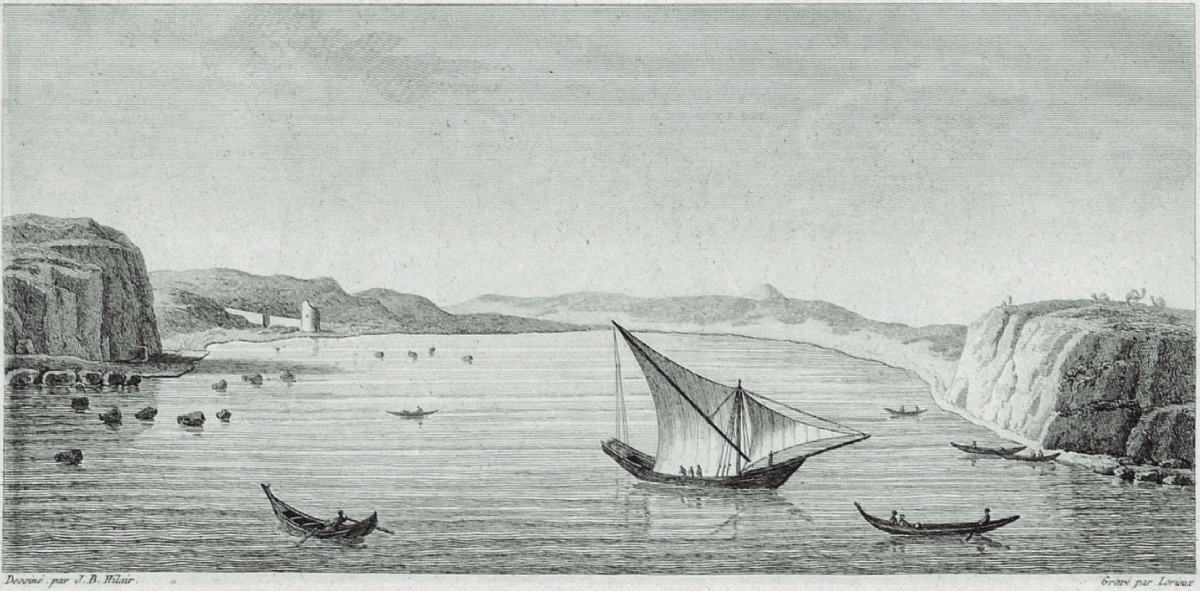
Kilya Bay on the Gallipoli Peninsula (1784, Aguste de Choiseul-Gouffier) We are not far from Alexandreia Troas, which we planned to visit. Travelers usually understand that they are approaching a large city by the increase in the number of people they encounter. But we see no one on the roads. Our guides in this country are the ruins scattered on the ground, and by the increase in these ruins, we understand that we are approaching a great ancient city or that we are already in such a city. Poujoulat, along with our interpreter Dimitri, leaves the caravan to see the ruins of this New Troy, which is at least as ruined as the old one. New Troy is more known by travelers and locals than the land of Priam. There are two main reasons for this; first, New Troy was confused with old Troy for a long time, and second, it served as a refuge in stormy seas or at least served this function for sailors. Hills come between us and the ruins of New Troy on our right, and we continue on our way. As we progress through a bare and wild valley, we find a river and water sources...
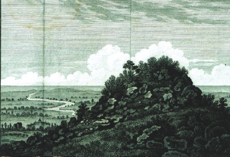
The Plain of Troy from the Tumuli of Hector and Aisyestes at Pınarbaşı Ballıdağ (1801, William Gell) At six o'clock in the evening, we reach the beautiful rural area of Geyikli Village. The inhabitants of Geyikli Village consist of Turks and Greeks. A poor Greek family opens their doors to us, but their tiny house is not enough for our caravan, so we spread out under the trees, mixed with our belongings and animals... We tour Geyikli Village and its surroundings. The land looks very rich and fertile, but the village is in poverty. We do not see any ruins that might be of interest in the vicinity...
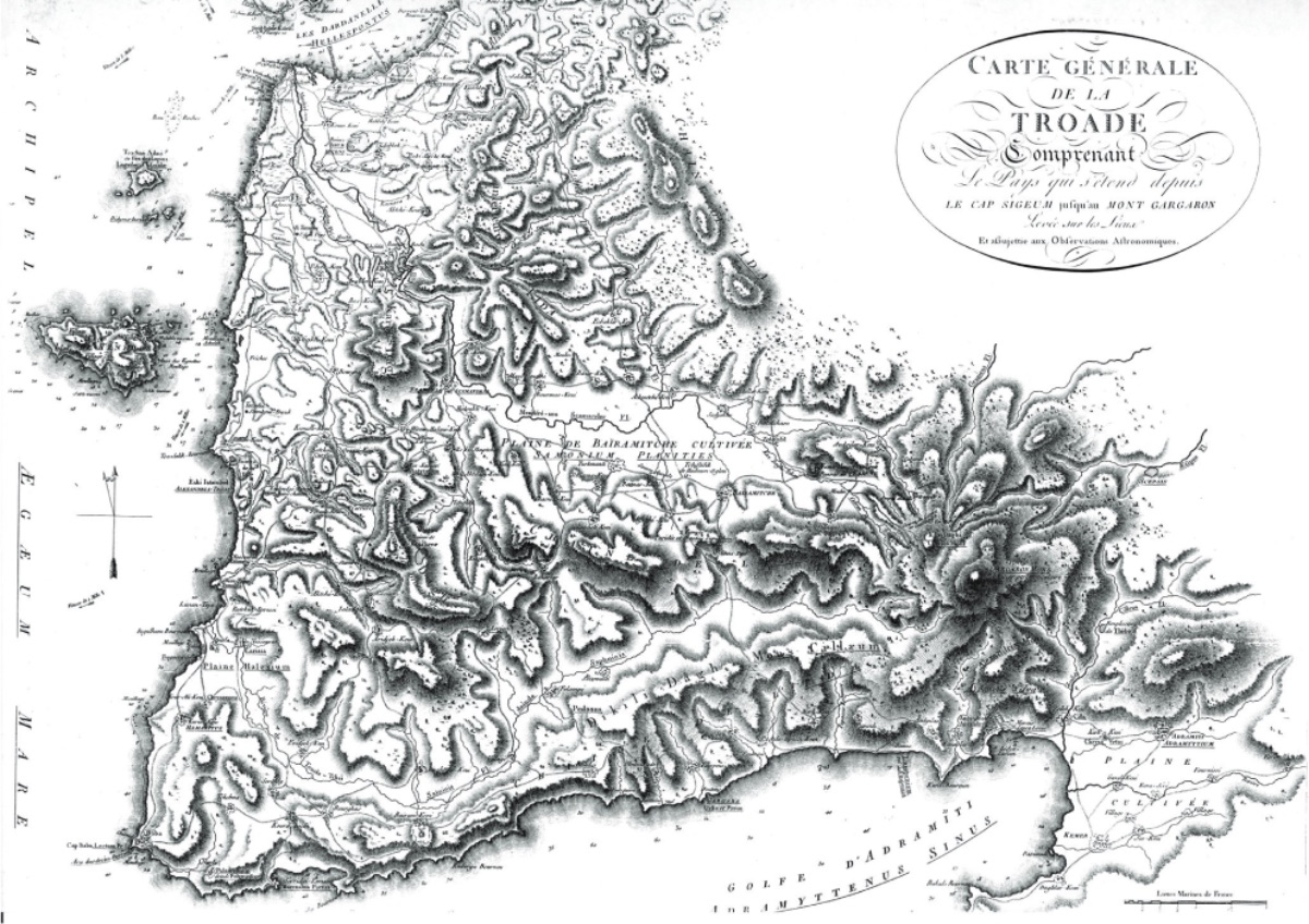
Alexandria Troas, which the Turks call Old Istanbul, is a city built on the slope of a hill inclined towards the sea, opposite Tenedos. Its most notable ruins are the aqueducts built by Herodes Atticus with its hot springs. Among these ruins, the baths known among sailors as Priam's Palace were considered a gymnasium by Pacocke and Chandler... You know that the ruins in this city have been an inexhaustible quarry for the Turks for centuries. It is almost impossible to find a single structure on the shores of Istanbul and the Hellespont that does not contain something from the plunder of Alexandreia. The Sultan Ahmed Mosque in Istanbul was almost entirely built using the columns of this city...The First Detailed Map of the Troad Region (1784, Aguste de Choiseul-Gouffier)
We started moving northeast from Geyikli. The magnificent views we saw on the road were places beyond the imagination of man. The sun rising on the Ida hills flooded the greenery covering the mountains with daylight.
A mile and a half walk from Geyikli, we saw a few huts inhabited by poor Muslim families. The appearance of these charcoal burners formed a strange contrast with the grandeur of the scenery. Around seven in the morning, we crossed the elevation known as Erineos or Wild Fig Hill, which descends to the sea, and reached Pınarbaşı village. The village, located on a pleasant sloping hillside, consists of about thirty households, all Turkish. As soon as we dismounted our horses, we wanted to see the source of Skamandros, because to find the location of ancient Troy, we have to start from these sources, the places described by Homer... A clear spring flows into a small pool surrounded by cut stones and granite columns. The pool under the cypresses is surrounded by fragrant flowers, herbs, and lush bushes...
We are advancing towards this great plain. First, we enter a deep valley covered with blackberries and wild artichokes, which makes our walk quite difficult. Then we climb the elevation where the acropolis is located. We don't need to tell you what visitors nourished by the memories of Homer and Vergilius feel here...
While climbing this hill, the tumulus known as Hector's Tomb first catches our attention. This tomb is in the form of a cylindrical flat area made of stones on the wide acropolis plain. The pyramid or top of the tumulus is either flattened or has disappeared over time. What remains is a base with a diameter of about seventy feet (1 foot = 30.48 cm: R.A.). After Hector's Tomb, it's the turn of another tumulus, Priam's Tomb. But I don't trust the specificity of this tomb very much. Since antiquity tells us nothing about this, I think we should add not having a tomb to the misfortunes that befell the last King of Troy...
Following the banks of Skamandros, we came to Kumkale yesterday, and today we climbed following the banks of Simoeis. When we crossed a wooden bridge about a mile above Kumkale, we reached a semi-cultivated, semi-stony land. On our left was the Halileli stream and the tomb of Aias, which visitors mistakenly thought belonged to Timbrius. Guided by the current cemetery of Kumköy, the first thing that catches our attention is the Greek ruins next to the Turkish graves, Agamemnon's army cemetery. The beautiful Dümrek valley, which should not be confused with the Thimbre valley, remains to our north. To the south is the winding Simoeis. Moving east, we reach the hills where New Troy is built. When we reach the hills, the tumulus known as Aietes' Tomb is seen to the east, and Çıplak village is to our north. The Old Kalafatlı Village located on the hills where New Troy is built and Çıplak Village located at the northern end of these hills are completely surrounded by ancient ruins. Among the scattered ruins between the central fortress of Troy and Çıplak, we find remains that we think are walls built during the time of Lysimachus...
Simoeis flows squeezed between two rocky and pine-covered mountains to Bayramiç, four hours southeast of the Troy acropolis. The river presents its wildest appearance in this region, and its bed can turn into a cliff-like deep crack in some places. In the riverbed we followed for two hours, we also saw uprooted logs, sand mounds the size of a person, and small islets with willows and plane trees growing on them. The river sometimes becomes extremely calm, almost turning into a pool, and in some places, it becomes turbulent and roaring. Both banks of the river are covered with frightening steep cliffs and shady pine forests. When you climb about five or six miles along the banks of Simoeis, you reach the city of Aineias, perched on the rocks, almost lost in the shade of cypress trees, overlooking a very large plain.
The tumulus adjacent to the city is known among the people as Enetepe or Savrantepe. Most scholars think this tomb belongs to the son of Anchises. The Bayramiç plain, stretching beyond this city, is fourteen to fifteen miles long. When the rainwaters around the Simoeis bed recede, just like the Nile river, these lands turn into very fertile agricultural areas, and the country's most beautiful watermelons are grown here throughout the summer... Near Bayramiç, to the east, there is a cone-shaped hill called Kurşuntepe by the locals. Ancient Skepsis rises on this hill. There, we encountered quite a few ruins. We found columns, pottery shards. Most wealthy people say that there was a temple dedicated to Zeus on top of this hill...
After a three-hour walk, we reached Avcılar Village. This village is the last settlement at the far end of the Troas region. After Avcılar, a desolate land and the steep cliffs of Ida begin...
We spent our last night in Pınarbaşı, at the farm of Captain Pasha, among poor Muslims. Before entering the shelter of hospitality, in the first hours of the night, we watched Troas sleeping while breathing the fresh air on Bateia hill...
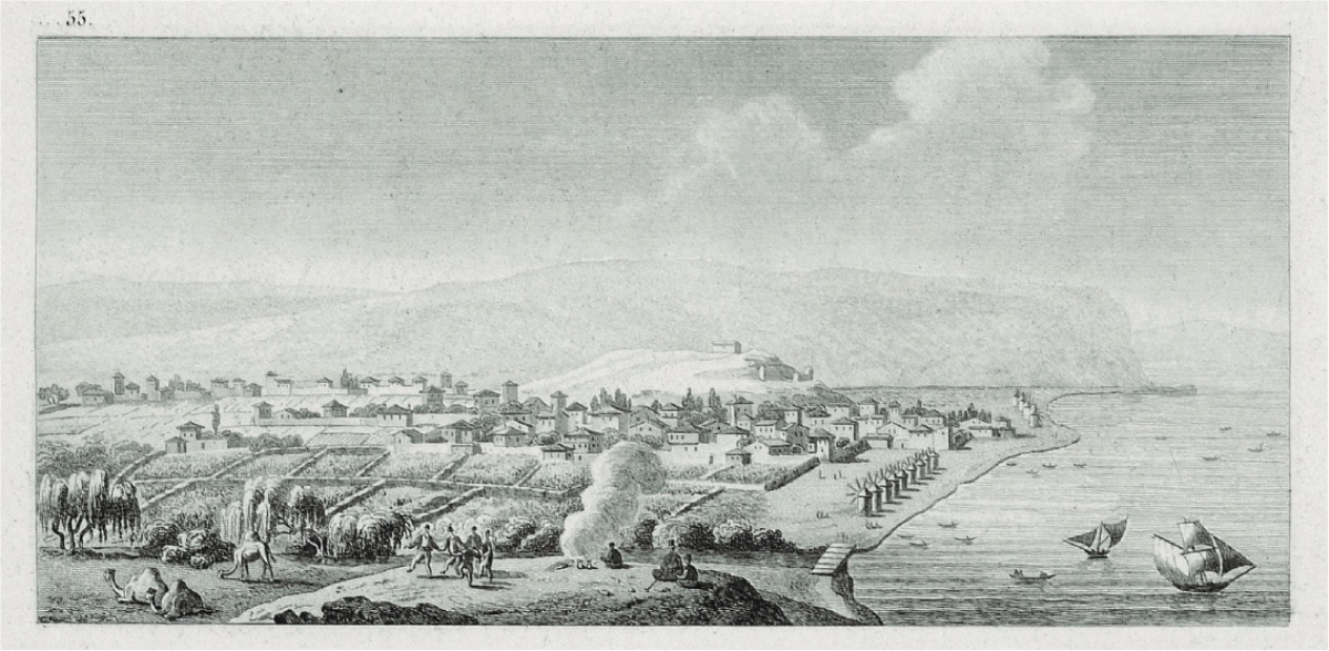
Yenişehir village is a village that can be distinguished from afar with its windmills spread over the hill. The village population, entirely composed of Greeks, is at most about nine hundred people. The origin of this Greek population, of course, dates back to the days when the settlement was an Antina colony. If we could stay among the Greeks of Yenişehir for a long time, we would probably encounter some habits and traces from ancient times in their daily lives. Traces of the past, including marble and bronze monuments, are generally much better preserved in narrow areas like villages than in large cities. Almost all of the Sakaiai people are engaged in agriculture, most of them own their land. Their houses are clean and functional. Like most Greeks, they love to eat, drink, sing, and have fun. But they also have a high tendency towards superstition.
In Yenişehir village, there are quite a few churches, the most important of which are Saint Jacque, Saint Spridion, and Saint Georges.
From the outside, the churches covered with red tiles resemble our rural barns or mountain houses in the Alps. As in most Greek churches, there is nothing but tasteless and worthless decoration in these irregular structures. However, travelers like us cannot help but stand in front of the door of one of these churches and look at the ancient marbles stretching like a street. In the past, people used to come to see the Skaiai stone, which had a very old inscription on it. Lord Elgin took this stone away, and now it's in England. The villagers speak of this theft with sadness; but their concern is not the ancient value of the stone, but the belief that it was good for persistent headaches. I have traveled so many places in the East, but nowhere have I heard talk of a statue or valuable marble being taken to France. As France, we have written very beautiful books about the East; but if we were to carry something from the East, it was only the pictures and shapes we carried on the map. But the English are not like us. Thousands of masterpieces that shone under the sun that currently illuminates us shine as much as they can in the foggy air of London...
We set out from Kumkale yesterday morning. After saluting the tomb of Achilles on our right and crossing the Simois stream over a half-ruined wooden bridge, we reached a marshy land where we couldn't see any particular feature. After a half-hour walk, we crossed the Halileli Stream over a stone bridge built with the remains of the Aias monument on our left... On the steep slopes, a few flocks of black goats were grazing. The hats made from bear and other wild animal skins, seen on the shepherds leading the flocks, caught our attention. Berber cape and white spots stretched out before us, and ships advancing in the Dardanelles were seen seeking a shelter behind the cape to protect themselves from the always fierce north winds... Since we were moving slowly, we had the opportunity to constantly observe the Hellespont and its shores...
The Dardanelles, despite being a well-known place with so much traffic, is not an easy place to navigate and contains various dangers. There are currents almost everywhere in the strait, and these currents can only be overcome with a good wind. No part of the strait is wide enough to allow large ships to maneuver to control adverse winds. Ships, which almost always have to progress along the coast and usually navigate between blind rocks, have to anchor every night. Sometimes, the ship skeletons seen scattered along the shores warn sailors that such a misfortune can happen at any moment. Moreover, if there is something that makes navigating this strait even more annoying, even driving one mad with anger, it is that some winds blow unchanged for months. The north wind prevails throughout the summer months in the strait, and the south wind throughout the winter months. Ships cannot descend the strait as long as the African wind blows. Under the north wind blowing from the Black Sea, it is not possible for them to pass from the Mediterranean to the Marmara. So, it is almost impossible to go to Istanbul by sea from June to September, and similarly, from October to April, it is almost impossible to go out to the Mediterranean by ship from Istanbul. At one point, it was thought to build steamships for the Dardanelles and have other ships pass the strait in their tow; but everything progresses so slowly in this country!...
Çanakkale is a beautiful city, with wooden houses covered with tiles. It is also quite rich in mosques and markets. Travelers and sailors passing through the strait meet their needs from this city. The city's population consists of Jews, Armenians, Greeks, and Turks. The Ottomans have a dominant position within the population. Including the military unit in the castle, the city's population is around five to six thousand people. The city is famous for chair making, and there is also a very large pottery factory. This factory we visited sends ceramic vases as far as Istanbul. Such production is very suitable for the needs of the country. The first furniture of a house or a small hut is a pot, a ceramic container. Someone living in this region would prefer a clay container to store water needed for ablution or every moment of life, rather than a place to shelter or clothing...
We went out for a walk around Çanakkale several times. The land is very fertile and generally well cultivated. Some slopes are covered with vines, and the wine of this region is very popular among Europeans living in the East. We toured the gardens on the western side of the city. We saw onions next to cabbage, lettuce next to onions, pumpkins a little further, and golden melons... I talked to the gardeners working in their fenced gardens through an interpreter. All of them were Greek gardeners who said that Turks respected their property and that no one took away what they worked hard to grow... We left the gardens and extended our walk to Rhodios. On the right bank of the river, a wall built like a rampart with large stones rises, made to prevent floods, it is clear that the river sometimes threatens to flood the city...
The French consul obtained a tezkere, or passport, for us from the Pasha, and we left Çanakkale to meet our boat anchored at Nara Burnu. The north wind was still blowing very hard, and the Greeks managing the boat advised us to wait for the sea to calm down a bit... However, despite the storm, we had a very good time. When we landed, we took shelter in a vineyard, forming a circle under a large walnut tree. After staying long enough among the protective branches of the walnut tree, we walked to the point where the city of Abydos is located. This piece of land extends in a triangular shape towards the sea, with a Turkish castle in its depths...
At four in the morning, the sailors came and told us that our boat was waiting for us. Since the wind was still blowing from the wrong direction, we thought we wouldn't progress much by sea and decided to go to Lampsakos or Lapseki by land... While we were there, we wanted to see the surroundings of Lapseki as well. Upon leaving the city, we encountered a plain to the southeast and a clean stream irrigating this plain. As we began to climb in the direction the stream came from, we first encountered very high, very dense groves; it was impossible to see the sky due to the density of the branches. The valley is entirely a vineyard and garden area. Everywhere is covered with vines and tall walnut trees, and it spreads in this way towards the north. Cherries came to us from the East; but until I reached Lapseki, I hadn't come across a cherry tree, I saw it here...
We crossed to the opposite side of the Dardanelles at a point not even two miles wide and anchored in front of the city of Gelibolu. As soon as we set foot on land, I inquired if there was a French consul here. They first took us to the Sardinian consulate. This Jewish official, from a Spanish family, received us very well; but since it was the Sabbath day, he probably didn't offer us a pipe and coffee...
After lunch, we went to visit our two consular friends. They offered to show us the places to see in the city. Of course, we were both surprised and very pleased... The Jewish consuls first took us to the market. Every product is sold in a separate area, and every craft or trade is practiced in a separate neighborhood or street. When you see silver vases stacked on top of each other, you know you are in the jeweler's street. If the street you enter carries the scent of rose water, know that you are in the perfumer's street. There is a separate street for fabrics and silks. The shops in Gelibolu seemed more select and more meticulous to us than the shops in Izmir. But what was really interesting in this city was the shoe market...
Today, Gelibolu is the foremost city of the entire Hellespontus region. It is estimated to have a population of about sixteen to eighteen thousand, consisting of Turks, Greeks, Armenians, and Jews. The city, sitting on a rocky layer divided by sea waters, has two harbors with very intense small boat traffic. Works related to the Turks, as in other places, consist only of mosques and fountains. Some of the fountains are made in the Arab style and are supported by columns, with Turkish inscriptions seen on them..."