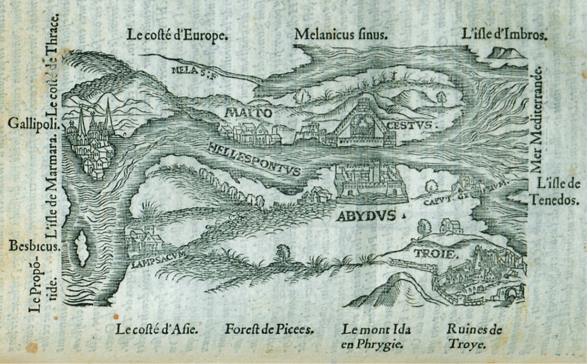
"From Mytilene (Metelin), we set sail along the coast of Anatolia (Natolia) or Asia Minor towards Cape Sigee, now called Cape Janissaries (Sailing towards Siegon/Rum village Yenişehir at the entrance of the strait, R.A.). Directly across from us, ten miles away, lies the island named Bozcaada (Tenedon) after Tenes, who first came to the island and founded a city there. Plinus (Pliny the Elder, a Roman geographer and natural philosopher, 23-79 AD, R.A) mentions in his natural history writings a naturally occurring water source on this island... Plinus states that during a solar eclipse, from the third to the sixth hour, this source temporarily floods the entire plain of the island, but for the rest of the year, it is dry and filled with ravines.
Strabon (Strabo, born in modern-day Amasya, 64 BC-24 AD, a Greek geographer of the Roman Republic period. His book on the historical geography of Anatolia is very important for Anatolia, R.A.) claims that the Temple of Neptune on the island was so significant that people from various regions came to the island to pay their respects.
On the opposite side of the island, between Cape Sigee and Xanthus, or Scamander (the river flowing in front of Troy in Homer's epics. Its modern name is the Karamenderes River, R.A), there are various ruins, wall fragments, foundations, columns, and buttresses belonging to the great and ancient city of Troy (this is actually Dalyan, Alexandria Troas, R.A). The ruins of this city, so glorified in ancient times and with the most unfortunate end, spread over such a long and wide area that it befits its known fame and grandeur. The Scamander River, originating from the foothills of Mount Ida (covered with pine, cypress, and many other fragrant trees of various sizes), flows slowly through the Mesaulon Valley (Arab Valley? R.A) and empties into the sea. From here, we entered the Hellespont Strait (Dardanelles); for security, there are two strong castles built by Mehmet II, who conquered Constantinople (Istanbul), one on the European shore of the Thracian Peninsula and the other on the shore of Asia Minor. Sometimes these castles are recalled with the love stories of Leander and Hero in the memories of poets as Seste and Abyde (Like some other travelers, here too, Kilitbahir and Çimenlik Castle are confused with Sestos/Akbaş Tepe and Abydos/Nara Cape, R.A.). The Seste on the European side (Kilitbahir Castle, R.A) is located at the foot of a mountain and consists of two interlocking towers in the form of a double clover leaf, circular and one-third of a circle. The triangular walls protect each other at every corner, and this castle always has war supplies and soldiers compared to the castle on the Asian side. The Abyde on the Asian side (Çimenlik Castle) is newer and stronger than Seste. The square-shaped castle is built on a magnificent beautiful cape, watered by the Simois (actually Sarı Çay, R.A) coming from Mount Ida, one of the most beautiful places I've seen, on a swampy plain with gardens and fruit trees, extending towards the sea. As I tried to say, there are round towers at every corner of the square-plan castle, and in the central courtyard, there is a high square-plan tower resembling a platform that sees and controls everywhere. All are beautifully and uniformly fortified, surrounded by a moat, and especially the front facing the sea, where attacks are generally made, is well equipped with enough war materials. On the side where the town is located, before the entrance of the castle; there is a large square with a market and a mosque. The guards shouted loudly for us to approach the shore. We wanted to anchor quite close to the castle, but if our patron had watched us, we wanted to use the advantage given by the very strong current there, but no good sailor's strength is enough here. The insufficient depth of the place caused him trouble. Seeing this, the guards approached the ship with a small boat. When they boarded the ship and saw the ambassador, they stated that it was a tradition for the ambassador to give some gifts to the captain of the castle and other officials. To satisfy their insatiable greed, he gave a few gold coins. Later that same day, we anchored again at the place where the large village called Maiton (Maydos/Eceabat), inhabited by Greeks, is located on the same shore as Seste. In the village, established at the foot of a hill by the sea where the walls of the old castle are visible, there are about two or three hundred houses. In the streets of the village and at the corners of the houses, there are beautiful columns and other remnants with broken figures. These remnants show that this place was once a known ancient site. There are very beautiful, fertile gardens and wide lands with vineyards here. A considerable amount of wine is produced and stored in large earthen jars buried in the ground to prevent spoilage. There are wide meadows and quality water coming from both wells and fountains. Thirty-six windmills can be seen on the seashore, each with ten wings. Many of these can also be seen at the Abydos castle. The next morning, while loading the wines we bought for our ship, two of the captain's crew complained to the ambassador for stealing the villagers' clothes; one of them was caught by three people on duty at the port, but the other escaped because he was fast. After dinner, we left here and sailed along the Greek land with the wind coming from the front. Three miles from Maiton (Mados/Eceabat), we passed the "Widow's Castle" (Çimpe or Kilya castle, R.A?), nothing is visible, only ruins remain. Below, a very fertile valley is visible. The Greeks (Rum) say that this is the place where the Turks first set foot from Asia to the Greek land. According to the stories, two Genoese transported them across with their ships for one gold coin each, and since they killed all the men in the castle; later this castle was named Widow's Castle. Around five in the evening, we arrived in front of the Gelibolu castle, thirty miles beyond the castles.
Gelibolu (Galliopoli) is an ancient city located on the Thracian Peninsula, overlooking the Sea of Marmara, opposite the city of Lapseki (Lamsakos/Lamsack) on the Asian shore. Some claim it was built by Caligula. Others, according to the French who lived here in the past; just as Nicopoli and Philipopoli indicate the city of Nicholas and Philip; Gallipoli also points to the Gauls (Gallia/Gauls living in the region of present-day France during the Roman Period, R.A.) or the French, and therefore, the French live in Gaul. There are six hundred households here, but generally, the houses are so dilapidated that it is not possible to see much that stands out. However, it has a port that can accommodate ships belonging to an army. Additionally, there is a castle that seems to have been quite strong in its time. But all are in ruins. In this city, there are many windmills and also two imarets (amaratabes). One of them, built by Sinan Pasha during the reign of Mehmet II, who conquered Constantinople, is located at the exit of the city on the road to Istanbul (Constantinople). Very close to here, the Great Turk had a very beautiful fountain built; water as thick as a human arm flows here. This water is transported to the city with earthen pipes; apart from this water, which is the best for them, there is no other drinking water; this water is neither good nor healthy. The other imaret is inside the city, and there are two very beautiful mosques connected to it: the city is open, without walls, like a village place, with very beautiful gardens and full of fruit. On a high area towards the sea from the cape, there is an octagonal area, and at the tip of the cape, many windmills can be seen.
A tax is paid for everyone, whether male, female, or child. This tax, which is quite difficult and called Piginte(?), is collected from the farms. Thirty thousand ducats (a silver or gold currency, R.A.) are paid annually to the Great Turk. Thus, they do very good business... Greeks, Jews, and Turks live in the city. Because it is a frequently visited place, food and drinks here are very expensive, and the residents do very good trade both by land and sea. A favorable wind arose for us, and we continued our journey..."