Pınarbaşı Village (1784, Aguste de Choiseul-Gouffier) Philip Hunt, the secretary and chaplain of the British ambassador in Istanbul, Lord Elgin, and Professor of Arabic languages Joseph Dacre Carlyle, who was tasked with creating a collection of manuscript Bibles, visited Çanakkale for the second time in March 1801. The purpose of this second visit after 1799 was to examine the topography of Homer and find the true location of Troy. Hunt and his companions began their visit from the coastal area of the Dardanelles, visited the plains and Mount Ida, then headed south to Assos and returned to Çanakkale along the coast. Hunt's report on this trip was published in the book of another traveler of the period, Robert Walpole, first in 1817 and then in the expanded edition in 1818. The report of Professor Joseph Dacre Carlyle was not published. However, later travelers used his unpublished report. Although archaeological elements are more prominent, interesting information about the socio-cultural structure of the Çanakkale Region at that time is provided:
"On March 3, 1801, we left Constantinople and on the 4th passed by the island now called Marmara, famous for its marble quarries, especially the high-quality gray marble brought in blocks for use in the mosques, baths, and tombstones of Constantinople...
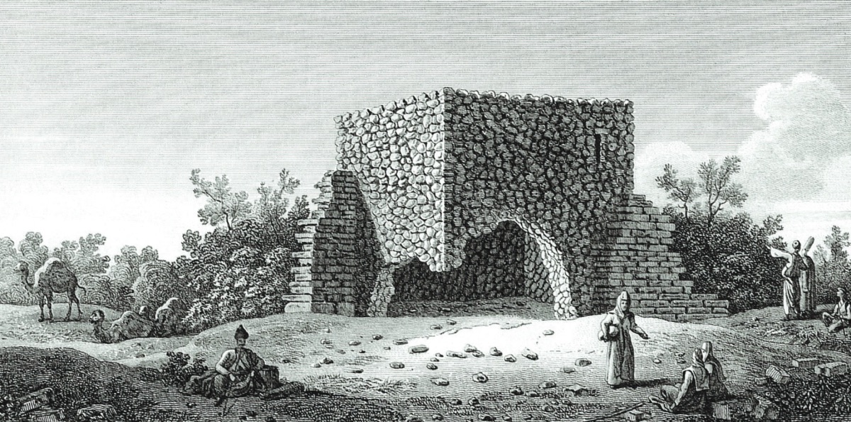
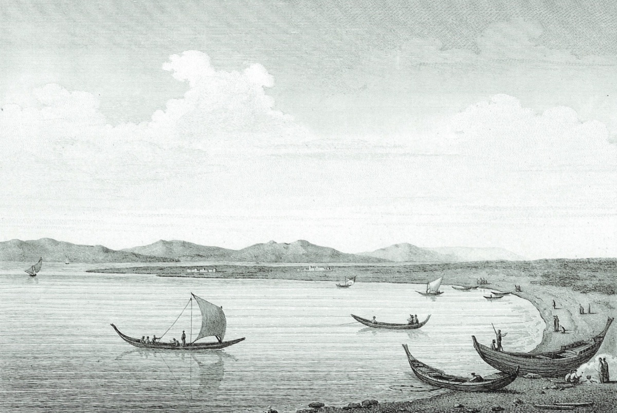
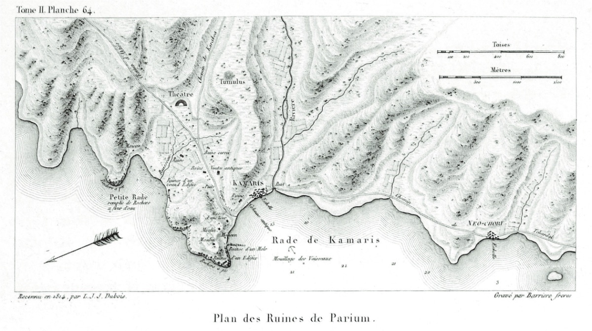
The wind began to blow against us, making it quite difficult as we approached the entrance of the Dardanelles (Hellespont). We saw a tumulus on the European shore; however, we could not advance for two days; we anchored at a small harbor on the Asian shore called Camaris. Here we went ashore and acquired some medallions, one of which was silver with the inscription Π Α Ρ Ι around an ancient mask. The copper one had the same inscription around an altar with incense burning on it. They are said to be quite common here. We believe the place we were at was the settlement of Parion, where Priapus had a temple built in his honor after being disgracefully humiliated in Lampsakos. The remains of city walls made of large square marbles without mortar can still be seen facing the sea. We saw the remains of an aqueduct, a water reservoir, and the fallen architrave of a columned entrance...
As the wind continued to blow unfavorably for us, we decided to disembark from the ship; leaving the English servants on deck, the rest of us set out towards Çanakkale (Dardanelles). In this village, they gave us and our interpreter only three horses. We took the owner of one of the horses as a guide; the horse owner, who would accompany us on foot, was very happy to see the shores of the Dardanelles (Hellespont) for the first time.
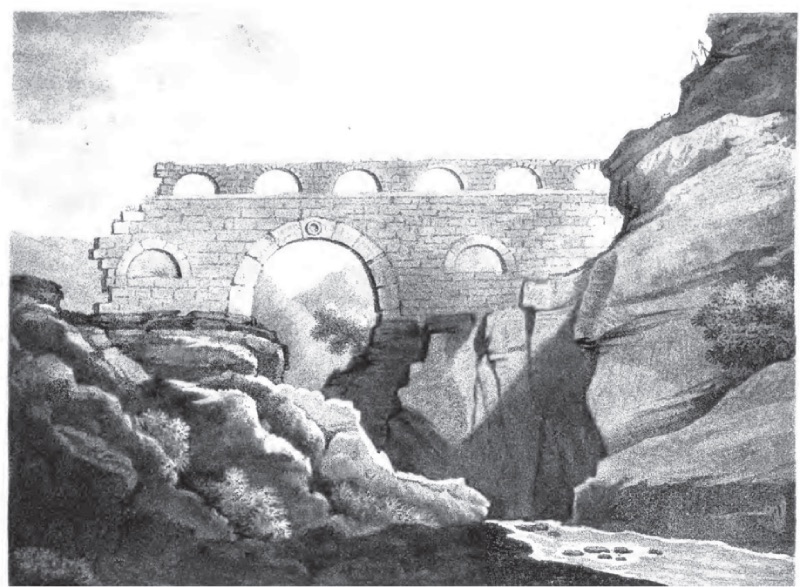
On March 6, we set out from Camaris at about half-past twelve and soon arrived at the place where the remains of two aqueducts that carried water to Parium were located. Here, there is a bridge built over a stream called Satal Tepe Sou (Çakal Tepe Su) or Satal Mountain River (Çakal Dağı Nehri?) in Turkish. Our guide said that Satal Mountain (Çakal Dağı?) is about four hours away and that there are ruins there as well. About three hours from Camaris, we came to a fertile plain called Corro Dere (Kuru Dere). After passing a hill, we encountered another valley. Spring was just beginning, and every corner of the grass was covered with vibrant clusters of red, white, and blue colors. These colors were intertwined with crocuses, wild leeks, hyacinths, and purple orchids; on the hill, various shrubs were quite impressive. Here we saw two types of strawberry trees, holm oaks in the beautiful bay, wild olives, various shrubs, heathers, blackthorns, wild grapes, and wild vines...
Ruins of Parion (1784, Aguste de Choiseul-Gouffier) As the sun set, we reached the Turkish village of Güreci (Jouragge). Almond trees scattered among the huts were in bloom. Here we realized that Lapseki (Lampsacus) was too far for our tired horses to reach that night. The husband of the woman we spoke to was returning from cutting wood; he looked at us and offered us a place to stay for us and our horses, which we gladly accepted. Later, he lit a large fire in the corner with a hole in the ceiling, and after drinking our coffee, he gave us pipes and tobacco and began to chat in a familial atmosphere. According to him, there are sixty families in Güreci (Jouragge), all Turkish; each has a piece of land in the valley and a few sheep and goats in the mountainous area. At harvest time, the local lord sends someone to measure the produce of each farm and takes one-tenth. This is the unchanging or constant tax paid by these Turks in this region of Anatolia. The collected produce belongs to the Sultan and is sold in certain quantities to some Beys and Pashas in this region. Then it is generally evaluated as agricultural produce by the local lord. The one-tenth share applies to all products from the land. However, it is strictly applied only to wheat. Except for a very greedy Ağa, an average amount is generally taken for fruits and vegetables. Our host complained about the war the Sultan had waged against the French. He said he could not get more than 120 bushels of wheat from his fields. His herd was small, and he had paid an extra 200 piastres in war tax last year. He then complained about the abuse of power by the port governor and said that the Turks would not be unhappy about his removal from office. He also complained about the excesses of the soldiers going to the camps of the Vizier in Syria. When news came that soldiers were passing through Güreci (Jouragee) during their journeys, the poor villagers would flee to the mountains with their belongings and stay in tents until the soldiers left.
In one of the houses, we saw a piece of a Greek inscription, and from another inscription next to an altar, now used as a mounting block, we learned that it was consecrated or made by Lucius Valeries Euthchus in memory of his mother and daughter.
Since the dirty beds and uneven earthen floor were not suitable for us to spend the whole night in Güreci (Jouragge), we set out at three in the morning by moonlight, passed through a dense wooded area, and returned to the shores of the Dardanelles (Hellespont). On the road, we saw camel caravans loaded with goods, each group lined up in rows of five. Here and later, we saw earthen mounds without turbaned tombstones or headstones. According to our guide, there were marked graves of travelers who were killed there along the roadside. Most likely, these individuals, who were itinerant Jews or Greeks, were not investigated by the local lord regarding how they were killed in the area. The geography here is quite different, with densely wooded hills and each valley flowing into the Dardanelles (Hellespont) with a small stream.
In a wide plain, we saw a shepherd's hut with a large number of camels grazing. In this season, the character of the male species of this animal changes completely and becomes wild; the shepherds have to make great efforts to prevent the camels from tearing each other apart. In İzmir (Smyrna) and other major cities of Anatolia, camel wrestling is among the most beloved entertainments of the people. At nine-thirty, we reached the Turkish village of Çardak (Sarthaki). The mosque's veranda is supported by granite columns and marble column capitals of different orders. They all seem to belong to an early Greek Imperial period church. At the fountain in the square, we saw three granite sarcophagi, with inscriptions that were damaged.
We could not reach Lapseki (Lampsacus), only six hours away from Güreci (Jouragee), until eleven o'clock. When we arrived, we went to the house of the Greek priest or monk and had breakfast. However, we could not escape the attention of curious Turks and had to endure these troublesome visitors, who were happy to show themselves to us for quite a long time. The poor Greek priest greeted them with such respect. Ruins of Parion (1784, Aguste de Choiseul-Gouffier)
On the way to the market or shops, some of them insulted us, but when we gave a few coins to the begging dervishes, they suddenly became more civilized. An Armenian shopkeeper showed us a small ancient Greek vase. Some said it was Etruscan work. This shopkeeper also had a few copper medallions; however, he set such an absurdly high price that we decided not to buy them. He said that similar vases to those he showed us were found in large numbers in an old cemetery area nearby. We found no remains or traces in Lapseki (Lampsacus). The wine, once famous in this region of Anatolia, is now among the worst. The town, with about five hundred houses, is populated by Turks, Greeks, Armenians, and Jews.
At a quarter past twelve, we set out again. We crossed the Chiergee (?) stream flowing by Lampsacus and saw another stream, which flows into the Dardanelles (Hellespont) at a point quite far from the European shore, about two hours from here (Umurbey Stream?). Later, we passed the village called Beergan (Bergaz) on the banks of this river. The groups of trees on the sloping hills above create a picturesque landscape around here, offering a magnificent view with a clear stream flowing from the valley.
Indeed, this entire coast has a rich geographical heritage continuously.
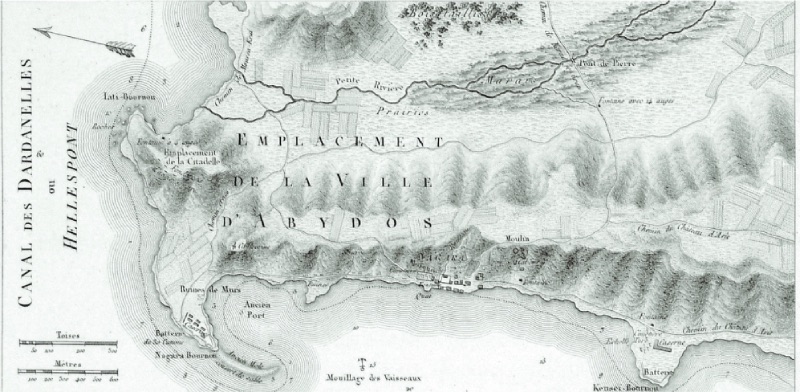
Four hours from Lapseki (Lampsacus) and a mile from the shore, we saw the remains of the walls of an ancient Greek town. The Turks call this place Kangırlı (Gangerlee); later, we crossed two streams, Yapıldak (Yapoudak) and Musa Köy (Moosah), one of which is the ancient Sarıçay (Rhodius) river. When we reached the fertile and beautiful Karayurt (Karajouree) valley, the Nara (Narla) cape, where Abydos once stood, came into view. After passing the village of Karacaören (Karadjo), we reached Çanakkale (Dardanelles) at about seven in the evening. Cape Nağara and Surroundings (1784, Aguste de Choiseul-Gouffier)
Here, we stayed at the house of the Jewish Senyör Tarragona, who has been the British consul for many years. Due to the Passover holiday, many members of the family had gathered. Here, Jews generally marry at eighteen; for girls, it is even earlier. One of the eighteen-year-old wives in this family was already a mother of three children at this age. A fourteen-year-old daughter had recently married, and their youngest daughter, the beautiful Rachel, as her father told us, had been sought for marriage by three different suitors.
The city of Dardanelles is called Chanak (Çanak) Castle by the Turks and Τα μεσα Κάστρα by the Greeks due to the nearby castles, and it is named Middle Castle because it is in the middle of the Dardanelles (Hellespont). The only garrison we saw here consisted of only three or four helmeted or Turkish artillerymen saluting the returning warships. The numerous cannons are on rather poor carriages; there are lighting places in the embrasures. The large cannons in a row have different calibers, and these cannons are at sea level; their holes are almost three fett (1 feet= 30, 48 cm. R.A.). We saw granite cannonballs piled in a pyramid shape for these large cannons. Our consul said that these were cut from columns found in Eski İstanbul, the name given by the Turks to Alexandria Troas. Instead of carriages, strong levers and pulleys are used to operate these large cannons. There are about two thousand families in Çanakkale (Dardanelles). Most of them are Turks, and there are about three hundred Jewish houses and a synagogue in the areas allocated for trade.
All kinds of food are quite abundant here, but we found that the price of everything in the city was twice what we paid during our trip. This situation arises due to the pressure of the governor, who applies a monopoly on wheat and food.
In Turkey, many things like oil, wine, fruit, and corn are sold by weight. An okka is about 2, ¾ avordupoise, or 400 drachms (1 okka is about 1.25 kg. R.A.); a kantar is 40 okkas, about one hundred English weights, and a kilo of wheat is equivalent to an English bushel. The coins are para and piastre; the value of a para is about half an English penny; 40 para make one piastre. Knowing these measures, I can understand the price of some of the foods I mentioned.
Almost directly across from us in Gelibolu (Gallipoli), a kilo of wheat is 100 para, while in Çanakkale (Dardanelles), it is five piastres, almost a bushel eight shillings. An okka of mutton has risen from 10 para to 18 para.
We did not find any remains or ancient artifacts belonging to the ancient city of Dardanos here; but we saw artifacts brought from Troas by a Jew to sell to English travelers. Among them was a statue of a woman brought from Chiblak (Hisarlık/ the Turkish village of Çıplak adjacent to Troy R.A.), a few hours inland. I bought it for Lord Elgin, who now has it in his collection.
Lapseki Bay (1784, Aguste de Choiseul-Gouffier) March 7. Before starting our tour of Troas, we were formally introduced to the governor of Çanakkale (Dardanelles), Hadımoğlu, by our Jewish consul to show our firmans and passports. He received us like a great statesman and said he would give orders so that we could travel comfortably in his area. Hadımoğlu is not only an important commander at the entrance of the Dardanelles (Hellespont) but also a Pasha and the feudal lord of the region we wanted to research. He is one of the richest people in Turkey. This wealth does not only come from the vast lands he owns in this area and other regions of Anatolia. It is also based on the bribes he takes from Greek merchants, who carry out their trade in these seas with ships under the Russian flag, which is part of the Ottoman subjects, but also from Austrian and Dubrovnik Republic and other trade ships carrying contraband goods and wheat. However, he is weak against the Captain Pasha, who does not turn a blind eye to illegal traffic that is not prohibited. Recently, when he anchored in the Dardanelles (Hellespont) during his expedition to Egypt, Hadımoğlu not only supplied all the needs of the Turkish fleet but also provided biscuits for their journey, but only collected 100 English pounds. Indeed, during his annual trip to collect the annual taxes from the Aegean islands, the Captain Pasha visited Hadımoğlu at his home appropriately and presented valuable gifts. However, what enters his coffers is not limited to this, complaints about his tolerance of smuggling reach the palace; therefore, he also regularly keeps an agent in Constantinople to find out if there are any complaints against him. Therefore, to prevent his wealth from being confiscated and a noose from being put around his neck, he sends forty to fifty purses of gold to his men in the courts. The Turkish financial administration is so corrupt that instead of having an active and independent customs officer in the Dardanelles (Hellespont) to prevent theft and greed, Hadımoğlu's son-in-law is in charge of that office, and he also prevents real and effective control from being carried out.
After showing him the firmans we had and the letter of recommendation we received from the Captain Pasha, he not only gave us a decree or identity written to all the Beys and Ağas in his region but also assigned an officer to accompany us throughout our visit to Troas. We also hired a boat to go to the Yenişehir cape for fifteen piastres (kuruş). Due to the currents brought by the cold north wind, we reached the cape in just under two hours. Our boat slowly approached the shore of the Dardanelles (Hellespont); the captain or master of the boat told us that the current flowing regularly at a speed of four miles per hour from the Black Sea and the Sea of Marmara to the Aegean islands made it very difficult for ships sailing against it, especially if the wind blew from the north, and this also affected the relationship between the Mediterranean and Constantinople (Constantinapole) throughout the summer. The seasonal winds (etesian) or the annual north winds starting in May continue until September, except for some short intervals and changes. The strait here is about 1.5 miles (1 mile= 1.6 km. R.A.).
The Dardanelles (Hellespontus) is quite beautiful here. The hills here are very steep; there are many trees, and the valleys extending inland are as green as in England. As a backdrop, the islands of Gökçeada (Imbros) and Semadirek (Samothrace) rise with their snowy peaks behind the Thracian peninsula. The first village we passed on the Asian shore is Kus Köy/Çınarlı (Cous-Keui), inhabited only by Turks, then we passed the village our guide first called Gavur Köy (GhiourKeui), İt Gelmez/Erenköy (Eet Guelmess); we soon learned that this name was used by Muslims for villages without Turkish families.
The rather ruthless and fair guardian of the region, given to us by Hadımoğlu, told us to understand what kind of place the region was, that his master had followed a thief from this village to the Gulf of Edremit (Adramyttian), caught him, and then flogged him until the nails in his shoes came out, cut off his ears, and if the person he robbed had not sent him to prison, he would have hanged him. After all, he was just a gavur or a faithless Christian.
Kemer Village (Parion) and Surroundings (1784, Aguste de Choiseul-Gouffier) We then passed Ak Yar on the Asian shore. This is a sudden appearance of limestone cliffs used by sailors to indicate that this part of the strait is shallow or that there are sunken rocks. On the opposite shore of the Thracian peninsula, magnificent beautiful valleys extend between the mountains; they are covered with rich greenery and have trees with shade everywhere. At the entrance of this valley, there is a small church built by Greek Christians, called Ayazma or a holy spring. The water here is said to have healing power against magic, the evil eye, jinn, and some other diseases. The conical hill nearby is thought to be Cynossema or the tomb of Hecuba.
As we approached the end of the Asian shore, we saw a hill called İn Tepe (En Tepe) by the Turks; Chevalier, Morrit, and other travelers have indicated that this is the tomb of Ajax. We then passed the Kum Kale (Coum-Kale) fortress, built on a small point that was once submerged under the waters of the Dardanelles (Hellespont) and later emerged like a sandy beach. About 200 steps northeast of the fortress, the mouth of the Menederes or Karamenderes River (Scamender), the largest river we saw after crossing the Sea of Marmara, flows into the strait. We then passed two more tumuli or conical hills very close to the shore. According to our guide, these are called Theoe Tepe, and they are believed to be the tombs of Achilles and Patroclus. When we reached the shores of the Yenişehir cape or the ancient Siegeum promontory, the sun was almost setting. The ascent was steep, but when we reached the top, we were met with the beautiful view of the Trojan plain, through which the river meandered. The island of Bozcaada (Tenedos) was right below us. Semadirek (Samothrace), Gökçeada (Imbros), and Limni (Lemnons) were on our right; on the opposite continent, the elegant Mount Athos was visible on the distant horizon.
The view in front of us, which we could see closely, has been compared to so many scenes from the Iliad and Odyssey Epics; springs, hills, streams, and other things, almost every stone in the plain below us, has been interpreted for some moments of the Trojan War. I will limit myself to describing what happened during our journey and the habits of the people living in the Troas region today. I will evaluate what I learned and what my skilled guide told me about the function of the region and its still-existing monuments in terms of their relationship with the regional scenes described in Homer's poems.
When my travel companion and I disembarked from the warship on leave in 1799, on our way to take up the embassy duty in the Ottoman Empire, the famous Sigean inscription and magnificent beautiful statue pieces were pointed out to us near this village. The first situation the Greek priest, in whose house we stayed, told us was the loss of these treasures. According to him, the artifacts were taken by a group of English soldiers (who were working on the repair of the fortress there) and their officers, who came from the Dardanelles (Dardanelles) with an imperial firman from Constantinople, stating that these marbles were given to the English ambassador Lord Elgin by the Sultan, with the order (Bouyurdee) of Hadımoğlu. The story told by the Greek priest with sighs and tears is not true; however, the story that glorifies the antique importance of this marble is far from what is known about it or its supposed connection with the divine Trojan epic. Because according to what they told us, his congregation lost a medicine they used against various severe illnesses.
Roman Period Aqueduct in Kemer Village (1801, Thomas Calyle) To explain this, it is necessary to state that a large part of this area is flooded during the winter and spring seasons, which causes fever and chills caused by malaria in the inhabitants here, and among the Christian Greeks, if a disease becomes chronic beyond their remedies, they associate it with demons. Priests or monks are called to exorcise the patient; this is usually done at the entrance of the church. A long passage from the Holy Bible is read over the sufferer, sometimes the entire four Gospels are read. In Yenişehir, in addition to this, the patient is laid on the marble with the Sigean inscription, believed to have healing power, whose meaning has never been deciphered. However, this practice has almost destroyed the inscription.
The exorcism practices of Greek priests are still in question on some of the Aegean islands, and this is not only for people; it is believed that large animals, silkworms, and even houses are subject to the evil influences of demons. In one of those ceremonies, I saw prayers being made to remove the evil eye on silkworms during the cocoon weaving season. In short, in one of the villages we visited, I witnessed a priest praying at the window sill with incense and a bowl of holy water to protect a newly built house from evil spirits.
Here we bought copper coins from the Ptolemies period and some small coins from Alexandria Troas; however, we could not persuade one of the villagers to sell the most beautiful one among them, a copper coin with a full female face on one side and two owls on the other.
All the inhabitants here are Christians affiliated with the Greek Church, and they seem quite poor and neglected. Their curiosity was so disturbing that we longed for the peace of a Turkish mansion. Nevertheless, with the Levantine Greek I learned, I was able to have a small conversation with the priest who hosted us without the help of our interpreter and gained some information about his own story and situation.
According to what he told me, Yenişehir or Gavur Köy is divided into two neighborhoods; his official income from the neighborhood where he is a priest is about 350 piastres or 250 sterling annually; however, he has to pay 150 piastres to the Bishopric center and the Metropolitan every year. His income is five para or two pence-half penny for baptizing; however, weddings and funeral ceremonies bring better income...
The next day, we needed to procure horses to ride around the plain, and here Mustafa began to use his authority for us and demanded four horses. However, when we saw that the owners were not happy at all, we privately told them that we would pay four and a half piastres per day for each horse, and they were very pleased, agreeing to accompany their horses as guides instead of sending a child to bring the horses back.
Our first stop on the road from Siegum to Çakal Tepe (Rhoetean) cape was the conical hills or elevations said to be the tumuli of Achilles and Patroclus, which we watched with the suspicion that we would not have time to examine them on our journey to Constantinople...
In 1787, the French ambassador M. Choiseul Gouffier hired someone to excavate what was called the Achilles tumulus, but the work did not go very deep, only to the surface where the tumulus rose. According to what Mr. M. Fauval told me, the ancient remains found here were a bronze Egyptian idol, common in the time of the Ptolemies and frequently found near Alexandria, with a symbol of fertility on its head, standing on two horses, with sphinxes on each shoulder.
The excavations are no more than a third of the depth of the tumulus. The diameter of the opened area is about five or six feet, and on one of the surfaces near the top of the excavation, I saw a square marble resembling a wall. I lifted it with difficulty and saw Greek writings on the side facing the ground, but when I examined it, I was disappointed to see that the short inscription was not of high antiquity in terms of form.
"Heroclea or Hieroclea, wife or daughter of Lucicus, farewell," it read. It was taken from there and given to Lord Elgin as Graf (writing).
Near the field where the tumulus is located, there is a white marble plaque with a relief of a laurel or olive wreath on it, but no inscription. This is a Jewish cemetery.
Heading towards Rhoetean cape via İn Tepe/Ajax (En Tepe tumulus), we crossed a river near the Kum Kale (Coum Kale) fortress, which our Turkish guide called Menderes Suyu (Mendere Sou) and the Greeks called Karamenderes (Scamander). The wooden bridge over it is a hundred feet long, and the river, compared to other streams flowing into the Dardanelles (Hellespont), is perhaps wide and fast-flowing. And here I cannot help but note that the water of the Hellespont gives the impression of a large river flowing into the Aegean Sea... The Patroclos tumulus near the road close to Achilles has not yet been excavated. It is believed that a monument was built in his memory and that his ashes were placed in the same urn and tumulus as Achilles'.
Four and a half miles from Yenişehir or Siegum, we reached a high hill called İn Tepe (En Tepe), thought to be the tumulus of Ajax. Before reaching it, we crossed Kemer Su (Camara Sou) and a salty marsh.
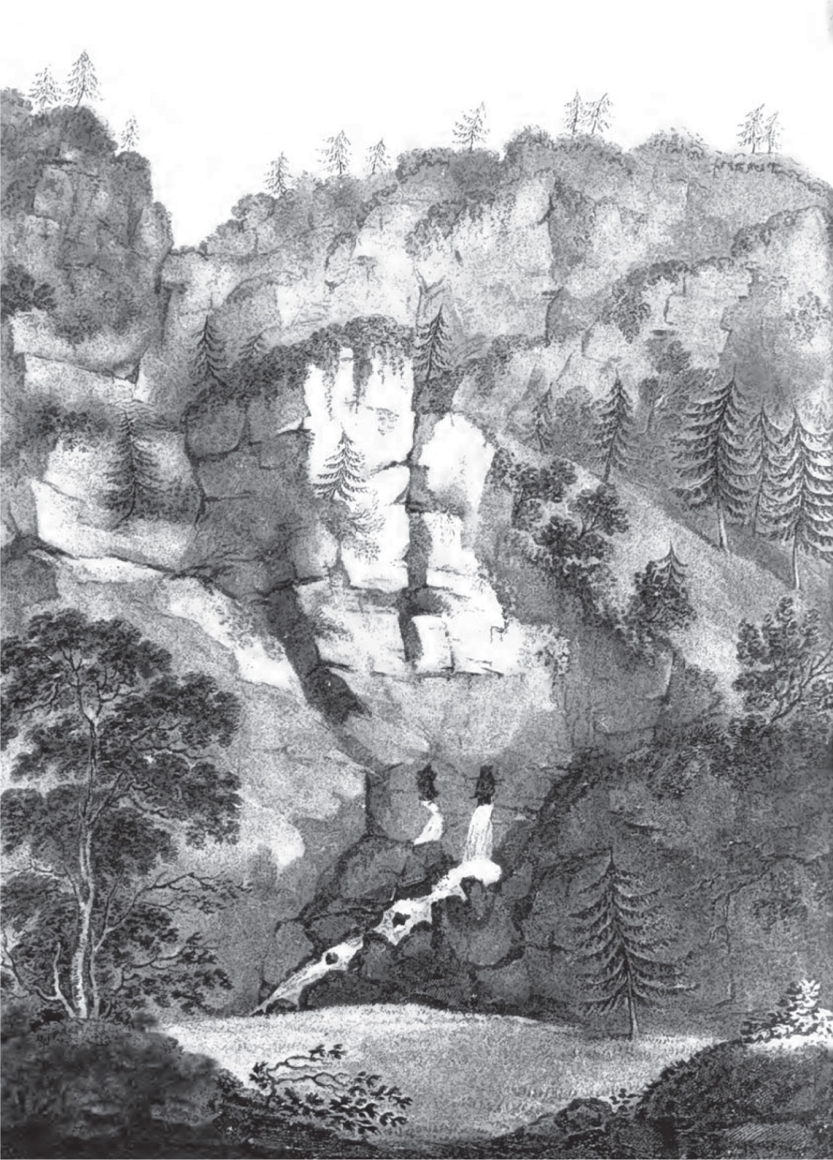
Water Sources in Kazdağı Ayazma (1801, Thomas Calyle) Our guide told us that a few years ago, the Turks excavated the tomb and extracted high-quality stones from it; these stones were used to build the current passageway through the nearby salty marsh and watery places. According to what they told us, the sea sometimes reaches here, and one of these ponds is called Tous-Lazma (Tuzla?), and the other is called En Tepe Lazma (?). This may confirm the views of those who believe that the waves of the Dardanelles (Hellespont) eroded the foundation of this tumulus after the Trojan War...
We are climbing towards the base of the slope formed by the hills ending at İn Tepe (En Tepe), and immediately we encounter a small stream, Kemer Su (Camara Sou) or the river of the aqueduct. We cross the small bridge over it and proceed towards the sandy village of Kum Köy (Coum Keu), about two miles south of İn Tepe. Near the village, the remains of a building belonging to an ancient public structure are scattered in the plain, most likely located above the city of Ilium. There are deep grooves on the ground and broken Ionic and Corinthian columns, generally three feet long and half a foot in diameter.
In the house of a Turk in this village, I found a Greek inscription on a marble block, the writings were quite small, and there were no spaces between the words. I bought this inscription for Lord Elgin, and it is now in his collection. It is not complete, broken, and damaged towards the end. I took the following copy on site. An honor award for Doctor Metrodorus for treating a wound on the neck of King Antiochus during the war. This service, but also due to what King Antiochus and the Seleucids did for their cities, some privileges and honors were given to him. Unfortunately, the name of the city is not mentioned in the information about this region of Troas...
About three and a half miles east of Kum Köy (Coum Keui), we found a dense Turkish cemetery with the ruins of a mosque with a standing minaret. This was within the territory of the village of Halileli (Chali-Leui). Column pieces, column capitals, and temple friezes were erected as tombstones on Muslim graves. The area they were scattered over was 260 steps wide, but we could not determine a plan or foundation belonging to a Greek or Roman structure. Some of the columns made of white marble, with a diameter of two feet (1 feet= 30, 48 cm, R.A.) six inches (1 inch= 2,, 54 cm, R.A.), are Ionic, some are Corinthian; the frieze pediments indicate that there was a Doric-style structure here; a damaged and broken relief depicts a woman in a chariot drawn by sea gods tritons; another piece shows the goddess of victory in a chariot, and on a part of the frieze beam, there is a depiction of a woman with wings supported by wreaths or flowers. There are other statue pieces, but they are so damaged that it is very difficult to understand what they represent. All the pieces, as seen in the assembled inscriptions, undoubtedly belong to New Ilium (Troy)...
One and a half miles (1 mile= 1.6 km. R.A.) southwest of these ruins in Halileli (Chali-Leui) is the village of Çıplak (Chiblak). We saw some architectural pieces made of marble in the courtyard of the mosque and the walls of some houses, and there are many broken column capitals and broken columns in the cemetery.
About a mile southeast of here, there is a very old Turkish cemetery area filled with temple ruins. Many inscribed marble pieces have been seen there. Among them, we also saw one...
From Halileli (Chali-Leui), we reached the Dümrek Stream (Gheumbrek Sou) flowing into Kemer Su (Camara Sou). We crossed it and reached the village of Gheumrek (Dümrek) in half an hour. The valley where Kemer (Camara) and Dümrek Stream (Gheumbrek Sou) flow is thought to be the Thymbra Valley; the valley is slightly elevated with hills and filled with beautiful shrubs.
The village of Dümrek (Gheumbreak) is four miles from Halileli (Chali-Leui), and the villagers took us to see the remains of ancient structures near a gloomy grove of tall pines. It seemed to us like the remains of a small Doric temple; however, there was no inscription piece or decorative sculptures indicating the period it was built or the name of the god it was dedicated to.
To increase our curiosity or for the guide to earn more fees, we were guaranteed that there was a large ruin four or five miles away that had never been visited by any traveler. Heading south among the mountains, in an hour and a half, we reached the ruins of a place called Old Akça Köy (Palaio Atche Keui) among the bushes and trees. On the way, Mustafa, who now understood our research, joyfully took us to a marble with a Greek inscription: it was the base of an Agrippa statue.
Next to this inscription is a seated female figure; a shawl delicately drapes over her chest, resting on her left knee. On either side of the chair, a lion sits... There are many inscriptions from different years scattered around...
The Place Where the Karamenederes River Flows into the Dardanelles (1801, William Gell) We now continued in a northeast direction and reached the bed of Kemer Su (Camara-Sou) again, which is quite wild and picturesque. We found an aqueduct built over the river, quite high from the riverbed. Although it has been quite damaged over time, it is still in good enough condition to give the river flowing beneath it the name "Kemer River." The main structure of the aqueduct is thirty-five feet in diameter and still intact; this place is three miles from the ruins of the Temple of Apollo in Ilium, Old Akça Köy (Palaio Atche Keui).
The rocky bed through which the river flows suddenly cuts off here, joining with the terraced aqueduct, and I regret not having the strength to sketch the impressive scenery crowned with trees here...
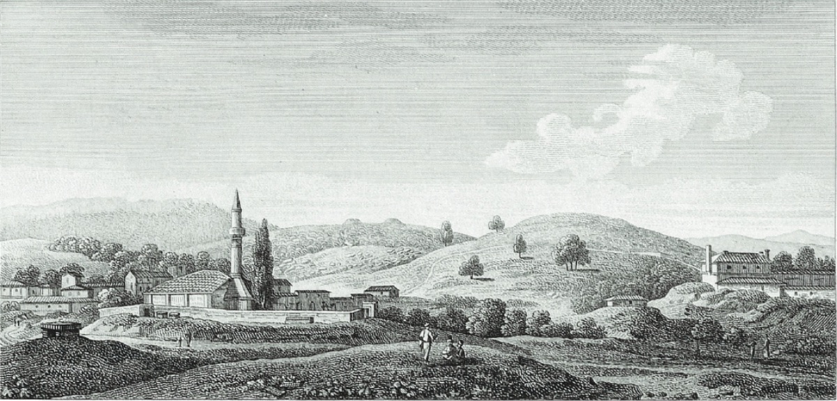
We now set out towards Pınarbaşı (Bounarbashi), where we stayed overnight, and proceeded in a southwest direction. We passed three tumuli named Mal Tepe, Asarlık Tepe (Asalack Tepe), and Hanaytepe (Khanina Tepe), as our guide told us; Asarlık Tepe is near New Akça Köy and larger than the others; about thirty miles high, with a flat top and a diameter of about one hundred feet. Its shape is a truncated cone.
After traveling three and a half miles further, we reached the Menderes River again, where the wide river joins the Trojan plain. To us, it was very wide but not deep enough to hesitate to cross on horseback. Our guide called this river Menderes and Scamandros and told us that its source came from the snow-covered Mount Ida. According to their calculations, it was three days' journey from here, approximately six miles: they also said that the source of Kemer Su was in the soft mountains. A mile from the Menderes River, we reached the village of Pınarbaşı. Quite high from the plain, it is about twelve miles from Yenişehir (Yenicher) and nine miles from the nearest point to the Dardanelles (Hellespont). Here we stayed at the farm of Hadim Oglou (Hadımoğlu).
In the east-southeast of here, the land rises about a mile and a half away, then reaches a largely flat hill. This place is called the Acropolis (fortress) of Troy. On our way, we saw no foundation or remains of any ancient structure, not even a broken stone or pottery shard indicating the people who once lived here. This high place or flat hill is about a mile in diameter, with an elongated shape, its length being 650 steps, meaning its width is 250 steps. We saw three mounds or conical hills on it; our guide calls this place Ballı Dağ (Ballh Tepe). On the northwest border, at the place they call Hector's tomb today, rough stone piles, as if extracted from the nearby quarry, are gathered together in a mixed manner, ready to be used. Right next to it are the foundations of walls; the masonry is rough and about seven feet thick; the foundation plan of the structure is irregular but placed on the uneven surface. The diameter is about forty steps. When we dug under these foundations, we found flooring and plaster. About 120 steps from this pile or mound is the second hill named Priamos tumulus by today's topographers. The remains of a structure are visible on the hill, an altar or a small chapel monument was built here, the diameter of the foundations is about eight feet...
About a quarter of a mile below the village of Pınarbaşı, in the southwest direction, there is a Turkish graveyard with many architectural, marble, and granite column pieces. Their styles are far from high antique quality. Neither on the hill nor on the road did we find remains resembling the Cyclopean wall style seen in Tiryns, Argos, Mycenae, and other regions of Greece. We did not see any vases or pottery pieces, which we see quite richly in the old city remains in Asia Minor and Greece. In different parts of the village, we saw a few relief pieces, one of which was a wreath relief hanging from a ram's head and an architectural ornament...
About a mile below the farm and mosque in Pınarbaşı (Bounarbashi), there are spring waters that are the source of a stream. The Turks call this place Kırkgözler (Kirk-joss). One of the strongest of these water sources has been shaped into a kind of reservoir or cistern and arranged by the villagers with some marble slabs and broken columns for washing their clothes and filling their containers. The temperature of the waters in these springs seemed normal to me, but according to what our guide told us, steam was rising while warmer waters were flowing from the adjacent springs...
The person in charge of the farm where we planned to spend the night treated us so rudely and disrespectfully that we left his house and went to the house of someone our guide knew. Meanwhile, they entertained us with a traditional concert and dance in the evening. One of the performers played a kind of small violin placed not under his arm but on his knee. Another in the group played a small guitar or a simple lute made from the shell of a tortoise frequently found on the neighboring hills. The two different types of siege engines (Testudo) I mentioned earlier, seen during our visit, reminded us of much older times. The carts or small chariots used in Troas have wheels and a sturdy structure; the general appearance of the carts resembles the war chariots depicted in the reliefs of Homeric heroes, ancient period reliefs, and Greek or Etruscan vases. Turkish ships navigating some parts of the Black Sea and Aegean islands also carry some ancient period features...
On March 12, we left Pınarbaşı, with the fortress and ruins on our left, and Üvecik Tepe (Udjek Tepe), thought to be the tomb of Aesyetes, on our right, or to the west. A mile and a half from Pınarbaşı, we reached a hill called Araplar Tepesi (Arabla Tepesi) by our guide. Its top is flat, and there were remains of some old structures on it. The Menderes River flows adjacent to the Arabs, and here the river is very beautiful; the steep cliffs on a terrace of Kara Dağ and the valley right next to it were filled with wildflowers. One side of the river was filled with oleanders, olive trees, and myrtle trees. The two streams of the river here formed an island, and many cattle were grazing there. Mustafa, who brought a beautiful hound with him, was still accompanying us from Pınarbaşı. This favorite dog has warm clothes like well-trained noble horses; there are spots of a reddish or dark orange color on the tail, ear tips, and some points on its back. This dye is still used by the Turks today, as it was in ancient times. Turkish beards are often dyed with this color, and I have frequently seen Turkish women applying it to their toenails and fingernails...
We are now leaving the main bed of the Menderes on our left and passing through the place called the Ezine Stream (Ene) plain, crossing a river that flows into it, and reaching the house of Hadımoğlu's son, the ağa or feudal chief, Hacı Ahmet, in the town of Ezine.
The name Hacı is added to the name either for those who have gone to Mecca or for those who have paid for someone to go on pilgrimage for them. The same suffix is used among Greek Christians for those who have visited the Holy Lands. Ene (Ezine) is thirteen miles from Pınarbaşı, and Hacı Ahmet lives here like a kind of feudal landlord. As we entered the courtyard of his house, a young man made a sound by hitting the drum hanging at the entrance. The ağa, whom we were immediately introduced to, welcomed us with courtesy and hospitality, but as a Muslim and a pilgrim, he did not serve wine at our meal to avoid sinning. He sent one of his guards with us as a guide to look at the antiques in the town and its surroundings, but what we discovered was not very significant. The first Greek inscription we saw was on the wall of a shop in the market, and it was broken and damaged...
Ezine is a large town with 800 families, mostly Turkish, and a small tannery is operating. The town's boys followed us in a crowd, but they did not behave rudely until the last moment. Shortly after half-past three in the afternoon, we left Ezine and the hospitable ağa; we continued with the river on our left. We plan to continue our journey towards Mount Ida, passing through a place called Kozlu Köy (Kozoul Keui). Five miles from Ezine, we reached a small stream called Balıklıdere (Baloukli Dere Sou), and a mile further, we reached another stream named Tchourmagee (?). Both flow into the Menderes River (Mendere Sou). We then passed Hadımoğlu's farm and reached Bayramiç (Bairamitche), the old settlement of the Hadımoğlu family, about fourteen miles from Ezine. Here we were well received and comfortably accommodated. The house is so large that we counted twenty-seven rooms opening into the main gallery.
There is an air of wealth and independent living in the town and its surroundings for a few miles: very well-cultivated fields, good fences, and solid houses indicate the comfortable life of those who manage them. Along the roads, there are wells and fountains to meet the needs of travelers. This is where Hadımoğlu's ancestors lived with a feudal title and patriarchal hospitality, and he was the first among his family to accept working dependent on the palace, enduring great difficulties, from his independence in the countryside. I had previously mentioned the serious accusations against him in Çanakkale and that the tenants working his land feared that he would oppress them in turn; all these would soon make him a victim of the institution he served, and thus the family that had long owned these lands would be destroyed. There are about six hundred families in Bayramiç (Bairamitche), and there is a large inn or caravanserai built for travelers to stay. In this inn, as we mentioned earlier, the two villagers who served us stayed three days before our arrival.
In one of the streets, we saw a granite sarcophagus used as a reservoir for a fountain, six feet long and two feet deep. We saw a very old inscription on it, but we could only read the following words, KAIK0ɸANEIA ≡ ENOɸAEI. Then we identified a writing similar to Xenophaë and Calliphaë, the name of an Ionian water nymph. In the courtyard of a house belonging to a Greek, we saw a small statue of a woman, almost complete and very beautifully crafted. The folds in her dress seem to be lifted upwards with her left knee. In the same Greek's house, there was the head of another large statue (Dr. Clarke discovered some important remains at Kouchounlou Tepe (Kurşunlu Tepe), about two hours from here).
Due to difficulties in finding horses, we stayed in Bayramiç (Bairamitche) until noon. As soon as the hospitable host prepared the horses for us, we set out towards Mount Ida. Although we were quite determined to reach its summit, the news we received dampened our hopes of reaching the summit, at least we wanted to reach the source of the Menderes, whose meanders we had been following for days. About five or six miles from Bayramiç (Bairamitche), the river we crossed was still called Scamender by our guide, and its width here was fifty or sixty steps. We saw remains of some ancient structures and passed through two small villages, both called Gavur Köy (Ghiour Keui) by our guide. Here the river began to flow faster and wider, and when we crossed it again, we saw that its width was no more than twenty-five steps. The valley here was so green, the shadows so restful, the water flowed so beautifully and clearly from its strong granite beds that it inspired us. The beauty and scenery around us were very striking; the majestic and beautiful tree-covered hills on either side did not let any glimmer of light pass through, so every shape of the oak was clearly visible. Forests, vineyards, pastures, houses, and herds were in an unparalleled harmony of colors. The summit of Mount Gargarus merged with the valley, and the snowy peak surrounded by dark pine trees shone brightly from afar.
At a quarter past four in the afternoon, we reached the village of Evciler (Evjilah) or the village of hunters at the foot of Mount Ida. Our reception here was the rudest and worst hospitality we had encountered so far; neither the ağa nor any villager thought of letting us inside their homes, and the only place they offered us for accommodation was a dilapidated adobe house. Showing the firman and order, meaning that the report we would give to those who gave us the firman upon our return would also include the ağa and his authority, a villager was sent to arrange a house for us. We had to make do with a coarse pastry and a rabbit brought by a villager from Mount Ida. As the weather began to chill us, a large fire was lit for us, and the oily pieces of long pine trees illuminated us instead of a lamp or candle. Although the locals here are Turks, they use the word Δαζα, which may be related to the ancient concept, for these torches.
The imam of the mosque and the elder of the village came to smoke their hookahs and chatted around the fire in the evening. When we offered them our coffee, they became more social and communicative. Among the visitors, the most intelligent one was a Turk who had sailed in his youth, seen the Black Sea and the coasts of Egypt. He now lives retired in his native village and also makes a living by producing wood tar and resin from the fir trees that grow for most of the year in Ida. In the winter months, he makes a living by hunting wild animals in the Gargarus mountains. He described the wonders of Mount Ida, its deep caves, streams, wells, waterfalls, and the view from its summit.
When we told him that the purpose of our trip was to climb to the summit of the mountain; he expressed his doubt that we would succeed in such a cold and difficult task at this time of year, but when he saw that we were determined to make this attempt, he said he could guide us. The next morning, we set out at a quarter to seven. The Menderes River is now about four yards (1 yard= 0.91 mt) wide, but its flow rate between the granite blocks is very strong and fast. We encountered a ruined structure in the riverbed, and those with us took some measurements. It seemed to me like the remains of a late Greek period church. Its length was fifteen steps, and its width was eight steps; the walls were four feet (1 feet= 30, 48 cm) thick and made of rather rough stone and mortar, but there were no column or statue remains here. Our guide called this place and some other remains we saw later Klishia; this name is clearly related to εκκλησία; it is most likely a Greek Caloyers settlement or a place from earlier periods.
We now began to climb the slopes of Mount Ida and soon reached the area with pines. During our ascent, we walked through a dense forest of rather long firs; these trees seem to be largely used for the production of resin, and along the way, we saw many large kilns used for boiling resin and concentrating it for tar. Considering that these vast forests were burning, we would be the only remains here, standing like black coal among the thousands of pines contrasting with the snow-covered hills. The tar kilns and a few huts where workers from Troas and also from the island of Salamis stayed seasonally to extract tar were the only building remains we saw in this interesting part of the mountain.
At a quarter past nine, or three hours after leaving Evciler, we reached the foot of the magnificent waterfall of the Menderes; the height of the waterfall is about fifty feet (1 feet= 30, 48 cm). Then, jumping from rock to rock, it reaches the plain about four hundred or five hundred feet from where the waterfall begins. We struggled over the rocks and rough ground towards the crevice in the rock that was our goal. From a distance, the Menderes water, causing a strong current, was flowing from the mouth of a wide cave extending towards the mountain with a violent explosion, noise, and deep sound in the open air. If this source is Scamender, it was no surprise to us, for in the days of mythology, only a river with such noble and mysterious divine sources could be blessed with the name Xanthos or Scamender...
On this fertile summit of Ida, there was a not very large flat area; it had an elongated shape and was surrounded by a wall made of rough stones, with a few small marble blocks inside. These additions may have belonged to a church here or were made to protect the sheep flocks grazing here in the summer.
Unfortunately, when we first arrived here, the snow was so heavy, and the weather was so foggy that we could see very little compared to what could be seen on clear days. With the brief appearance of the sun, we could see the entire Menderes (Scamandrian) plain spreading beneath our feet, with the river winding through the serpentine. At this moment, our guide pointed out some places on the distant horizon; Gökçeada (Imbroz island) and Semadirek (Samothrace), Mount Athos in Macedonia, Alexandira Troas, Sigeum, and Euxine (Black Sea). I drew a circle around him in the snow, trying to understand the topography as much as this old sailor could tell me. Since we had no idea about the height, I indicated the height of 775 toise (1 toise is six feet in France until 1812 = approximately 1.949 meters) calculated by Mr. Kauffer, the German engineer in the service of M. Choiseul Gouffier, from the height of the archipelago...
We are now returning to the dark forests and rocks of Ida and soon reached Evciler, where we saw that the villagers were surprised that we had climbed to the summit of Mount Ida. Here we ate our rather simple meal, our bread was the worst we had seen so far, made of unleavened white cornmeal.
There are about thirty houses in Evciler, all Muslim. Their houses are very poor, the walls are made of adobe, and the roofs are made of brushwood or earth thrown over horizontal fir beams. In good weather, the Turks spend most of their leisure time on the terraces of these houses; below is a large gloomy room, and on most of these roofs, there is a small granite column piece, which they roll over the soft surfaces. The only person here who seems to need something is a Turk who served in the governor's service in Çanakkale (Dardanelles) and returned to his village as a retiree after saving some money, now filling the place of the Ağa and acting as a mayor or peace judge. He built a mosque here with his own money; the imam or person in charge of the mosque visited us: His income was set at sixty piastres, less than four pounds a year; he was officially responsible for the mosque and school. Sometimes circumcision and funeral ceremonies were also added to these. For his livelihood, he depended more on the products of his small farm than on his profession. The residents of the village make a living more from cattle grazing and hunting than from agriculture; they generally seem to enjoy life, but we were surprised by the high prices they asked for the small things they reluctantly gave us. Our guide also took seven piastres (or half a guinea) in advance before we climbed to the summit of Mount Ida with us and said that others from our country had given him twice this amount.
During dinner, the workers covered in soot from the tar kilns came to chat with us; they told us they were Christians from the island of Salamis; they also mentioned that they were affected by the annual ship service sent by the Captain Pasha to work some villagers in the forests of Ida.
After spending a night in Evciler, we gathered our strength and began our return journey to Yenişehir the next day; our route directed us to a region of ancient Skepsi; we sometimes used the road we came from and then crossed a branch of the Menderes, which is dry in the summer (Chiousluk Sou'nu (?)). Our path was on the western terraces of the Menderes. Four miles from Evciler, we passed through the rich valley of Bayramiç and continued to the left. Two miles further, we crossed a wide but shallow stream called Yasbekal-Chaya. In the Turkish cemetery here, I saw some pieces belonging to an ancient structure. Four miles from here, we reached Kızılköy (Kezil Tepe) on a windy hill. Here we rested under the Eastern plane trees and then passed through the Turkish village of Örenli (Oranjaou) and immediately saw a fountain flowing by the roadside; we reached the cultivated and fenced lands belonging to the Hadımoğlu family again. The source of the Sanderlee stream is magnificent, and after the monotonous pine forests, the bright green of the walnut trees nearby and the snows on Gargaros were very pleasing to the eye.
In the evening, we reached Büyük Pınarbaşı (Boyuk Bounarbashi) (this name is used to distinguish it from the other village name in the Scamandriya plain R.A.). The village was quite lively and noisy due to a Turkish wedding, and before retiring to rest, the music group brought from Çanakkale (Dardanelles) for the wedding came to us with their dancers. They made their music with three instruments similar to clarinets and drums of different sizes. The shrill sound from the pipes and the noise of the drums were not at all suitable for the small space we were sitting in. Both the musicians and the dancers were gypsies in Turkish costumes; one played the role of a clown or jester, and the dance was so indecent that we immediately sent them back.
According to what Hadımoğlu told us, Büyük Pınarbaşı, about twenty miles from Evciler at the foot of Gargaros, is richer than the Pınarbaşı we visited earlier near Yenişehir. Like the one with the other name, it also has water sources nearby. A large modern fountain made from stones probably brought from a nearby ruin was built from three springs; but we saw no inscriptions or statues from the ancient period: there were a few granite columns at the boundary of the cemetery.
From here, we went southwest, passing a village called Türkmenli (Turmanly); our path advanced through the plain of Salkecheui Stream, located right at the border of a hill called Karadağ. There was another village called Sapoory (?) that we passed without stopping, and about fourteen miles from Büyük Pınarbaşı, we reached Ayvacık (Aivajek). There are about two hundred houses in this town; the responsibility of this place is with Osman Ağa, independent of Hadımoğlu, or at least he wants to leave such an impression on us by belittling the governor's order. We were received rudely and disrespectfully here, and we were sent to an inn to wait for the suspicious ağa to come and check our passports and interrogate our guide. He did not accept us and ordered us to leave his territory without delay, and we left as soon as we found a few horses. The inn where we were detained was built during the time of this ağa; it has about thirty rooms side by side, some of which are rented to basket makers, tailors, or craftsmen who come and stay here from time to time. We left the inhospitable Ayvacık, following a winding road through the mountains, reaching a flowing river called Tuzla Stream (Tousla Chya) or salt marsh in many places with long and narrow ravines. Here we saw the Edremit (Adramyttium) gulf and its small archipelago for the first time. Eight miles from Ayvacık, near the Turkish village of Behramkale (Behram), there are ancient ruins spread over a large area; the proportions of the ruins are so large and beautiful that the poor Turkish village of Behram's houses look like the huts of a nomadic group today.
The next morning, we began to curiously examine the magnificent ruins of the city, accepted as Assos. Here, we were lucky enough to encounter a careful host and a useful guide waiting for us at the entrance of the city. He told us that he was aware of the presence of two English travelers who wanted to explore the places near the roads leading to Alexandria Troas, so he arranged accommodation for us, and the Ağa sent food for us with him. He was a sailor from Midilli. For dinner, there was a thick soup made from barley, baked pastry with spinach, and pilaf drizzled with heavy butter; there was also a buttered bun floating in honey.
March 17. Assos is located on a hill descending in terraces towards the sea and has a commanding position over the Midilli (Lesbos) and Edremit (Adramyttian) gulf. Its walls are quite strong and about 5 miles in circumference. Three ancient city entrance roads are quite well preserved; the fourth is in ruins; the high walls originally formed the "ΑσΤυ" acropolis or fortress, with its terraced side made of granite rocks. On the hill, after the revolution, there are the remains of a Genoese castle, a Greek church, and an old building converted into a Turkish mosque today...
In different parts of the ancient city, we came across piles of broken vases very well made, with beautiful black patterns, called Etruscan and Greek. Anyone who excavates here could discover very valuable remains of ancient period art.
Unfortunately, we could not find an inscription bearing the name of the city or a Greek coin. Our guide found many copper coins here, but they are not very valuable, and their writings are not legible. According to the tradition of those living here today, this was a Genoese castle.
At half-past three in the afternoon, we left these interesting ruins and began to head north. A mile and a half from Behramkale (Beyram), we crossed the water named Tuzla Stream (Tousla Chya) or salt river. There are high hills on the right; then we entered a plain surrounded by large rocks, the highest of which was called Topal Tepesi. Six miles north of Beyram, we crossed the Goulfa Chya (?) flowing into Tousla Chya. After climbing some terraced hills, we reached Tamış (Tamush), a small village nine miles north of Beyram, outside Beergaz village. It is established in a rocky place where many goat herds graze; below are wide depressions and small valleys. We found the Ağa alone and thoughtful. He honored us in a distant manner and sent dinner to the hut where we stayed. He did not ask many questions, only whether we had a watch, pistol, or binoculars in exchange for a hunting dog. He gave evasive answers to all our questions about the history of this place. When leaving, he warned us to refrain from wine in the room we stayed in, as the carpets and mats on the floor were used by Muslims during prayer times and should not be soiled. He even sent five or six of his men to stay in the room we stayed in all night; although one of them dismissed these unnecessary agents, one sat on the side of the carpet we were lying on all night. There are about fifty families here, all Turkish, except for the Hacı Ağa, who has gone to Mecca and learned hospitality, they are all as ignorant as grazing goats. The next morning, we were allowed to go to the hill with a few guards of the Ağa and look at the town from there. From there, we saw the bed of Tuzla Stream; they told us that the water flowed into the sea three hours north of Baba Burnu (Baba Bournou) and three leagues from Old Istanbul (Alexandria Troas). The plain where the river mouth flows into the sea is called Keçideresi altı (Tchesederesi). Our path passed through a small valley with one steep side, called Çıyanderesi (Tscahyanderesi) or devil's pit. Until we reached Tuzla Mountain, the Gargaros mountain range or the western continuation of Ida was in question. Seven miles from Tamış (Tamush), we stopped in a village called Baba Deresi. Here, our friendly guide, the sailor who hosted us in Beyram, gave us quite interesting information about a place called Tuzla (Tousla) nearby. There are hot springs and salt works, and if we take another road only an hour away from our route to Alexandria Troas, we can go there, he said. We decided to go in that direction. In Baba Deresi, there is a poor mosque with adobe walls, but its veranda is supported by three ancient period columns with unique craftsmanship and different style capitals. There are a few ancient marbles in the village cemetery.
In an hour, we reached the shallow pools where the salty waters are evaporated. The salt sources here are so rich that as much salt as desired can be collected, and the rest is left to Tuzla Stream, from where it flows into the sea. Here, 100,000 buckets of fine white salt are obtained annually. Hadımoğlu has a monopoly, having purchased the sources or having the authority to operate them from the Sultan. One hot spring has been made into a bath. Its roof is filled with hair knots and a piece of clothing or metal-coated materials offered as votive offerings by patients using the place. After passing Tuzla town, we really reached the main hot springs that rise quite high from their source, and the waters gush upwards with great pressure before flowing to the ground. The temperature is at boiling water level, and the nearby stones look burnt. About a hundred meters from these intense sources, there is a separate channel with a cold water source flowing into Tuzla river. A green barrier separates the hot spring from the cold spring.
The weather was so hot that our guide and those accompanying us were not very willing to climb the hill with us to see a general view. Therefore, Mr. Carlyle and I set out together and from there saw the approximately three-mile distance from the salt springs to where they flow into Tuzla river. On our way, we saw weak remains of structures, but when we got there, we did not encounter any building remains. The high mountains of Baba Burnu or Lectum Cape prevented us from seeing Athos on the opposite Macedonian shores. After rejoining our group in Tuzla, we returned to the road we had left. Mustafa, whom we sent ahead to arrange accommodation for us in Kösedere (Tscesdere), soon passed us. We saw many Turkish farmers working together in the vineyards and learned that it is a tradition to help each other during the ripening period and harvest time of the fruits. However, the vineyards are not cultivated for winemaking; the grapes are used by the Turks as fruit and raisins. They also make a syrup called Pekmez (Petmez) from the grapes; they use this product, which is like dried sweet-meat, as a substitute for sugar when making sherbet. There are about three hundred houses in the Turkish town of Kösedere, under the administration of the Ayvacık ağa, and Ali Ağa lives here representing him: Ali Ağa has surrounded the cemetery with a wall; we have not seen another cemetery place protected in this way in Troas.
At half-past three in the afternoon, we could see the sea again, and we entered Hadımoğlu's territory again. Here the border is marked by a tumulus called Vezir (Vizier) or Pasha Tepe. Towards the coast, there are many tumuli for which our guide could not find another name than Beşik Tepe (Beş Tepe), the five tumuli.
Our path now led us towards a forest of oak trees. The large acorns with shells are used in dyeing and are the most important export product in this region of Turkey. These trees are now full of leaves.
March 18. The valley extending towards the sea from here is called Olimichi Ouessi (?). At five o'clock, we reached a place with ruins and saw many broken sarcophagi. In a Turkish bath built over a natural hot spring (Kestanbul), there is a statue of a woman. Shortly after, we reached the ancient aqueduct called the Old Istanbul Gate by our guide, the name given by the Turks to Alexandria Troas. Due to the intense day, we could not visit these dense ruins, and therefore we stopped in Geyikli (Gaikli) where we spent the night. Until a few years ago, there were about one hundred and fifty Turkish families in this village, but most were sent into exile by their Ağas to a place very close to Bozcaada (Tenedos) for causing trouble. Currently, there are no more than twenty-five houses living here.
When we told our host that we wanted to visit the ruins of Old Istanbul; he told us that Hadımoğlu's herds were grazing nearby and that they were guarded by about fifty guard dogs, and it was very dangerous for strangers to pass among them. Nevertheless, a few piastres were enough for him to go ahead and tell the shepherd that the friends of the patron would visit the ruins, and true or false, these alleged dangers were removed.
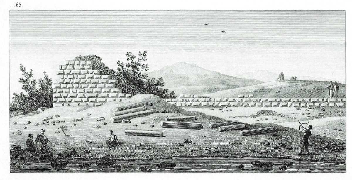
The next morning, after passing through the ruins of the ancient aqueduct built by Herodes Atticus and turning right, we soon reached an important building, possibly an old bath, with its interior regularly lined with pipes. Next to it is a base made of stone and mortar, perhaps used in an entrance road. Our guide tried to convince us that the ruins were supposedly the Palace of Priamos. The remains seem to have been built as a gymnasium with a bath during the time of Hadrian and the Antonines... Next to the ancient harbor, we saw a pile of granite cannonballs ordered by the last Captain Pasha for the needs of the fortresses in Çanakkale (Dardanelles).
We left the ruins of Alexandria Troas and soon after passing through the pine forest in Geyikli, we reached Yenişehir (Yenicher) at one o'clock. On our way, we saw a lake called Yole (?) near the shore, most likely Strabo's Pteleos; on the right was a hill or tumulus called Devise Tepe. Later, we reached a canal or watercourse opened to bring water from Pınarbaşı's Kırkgözler to the water mill at the farm here. The villagers said that it was built about fifty years ago by Hanım Sultan, the owner of the land here, and later transferred to Hasan Pasha, who repaired it.
March 19. We crossed this small stream with a bridge and continued our route along the spring water lake for almost three miles. Not far from the shore on our left is a conical hill thought to be Peneleus, and between us and Pınarbaşı is the quite noticeable Üvecik Tepe (Udjek-Tepe) or Aesyetes tomb hill.
When we reached Yeniköy or Neachore, as the Greeks call it, we stopped to examine the church of the village where we copied a Latin inscription.
C. MARCIVS. MARSV
V. F. SIBI ET SVIS
Here we encountered a rather talkative peddler who respectfully provided us with the following information about this region of Troas.
There are about one hundred Greek Christian families in Neachore; seventy of them are landowners and farmers, and thirty are workers and shopkeepers. Instead of the state's tithe tax, which does not exceed ten percent of the product, the coercive Ağa takes eight percent from the producer for the palace.
The per capita tax is calculated as follows: Adult men pay five piastres a year, young men three, and adult men two and a half. Neither women nor children are subject to this tax... Young women are mostly employed in wool spinning; their average income is one shilling for one hundred drachms in four days, and they receive 24 para, about one shilling; a loaf of bread is two kuruş... Those who are unable to work or are very old are supported by the barley given by each farmer at a certain rate, with a quota of eighteen buckets of barley per poor family per year. Money is also collected by the priest at important ceremonies in the church for the poor, and this is generally used to pay their house rents...
We have now completed our tour of the Troas region. In this tour, I noted many findings important for ancient art craftsmanship or tried to describe the history and geography of the region..."