Tumulus of Achilles (1801, William Gell) Richard Pococke (1704-1765), a member of the British Royal and London Society of Ancient Cultures, traveled through European countries from 1733-36 and arrived in Alexandria in 1738. Pococke, who stayed here for three years, traveled extensively in the Eastern Mediterranean countries (especially Greece and Anatolia) in 1840. As part of this journey, he examined the Çanakkale Region in 1740. Pococke also visited Istanbul and its surroundings, as well as various cities in Anatolia up to Bursa and Ankara. Upon returning to his country after this journey, he became the archbishop in the Irish church. However, he is better known for his diaries written during his travels, published in 1745. Pococke's observations on the Çanakkale Region, especially the Troy Plain and its surroundings, are of great importance as they are the first detailed and accurate interpretations. Pococke is also the first European to research the origins of medieval Arabic texts. His diaries clearly reflect the prevailing admiration for Greek culture (Philhellenism) of the time:
"After leaving Istanbul (Constantinopolis), I went from the Dardanelles (Dardanelle) to Tenedos (Bozcaada). This island was called Calydna in ancient times, and there are two more islands to the south of the island; these islands are still called by the same name today, but the name Leucophrys is also used. Ancient sources say the island is five miles (1 mile = 1609 mt. R.A.) from the mainland, but now it is calculated to be nine miles; it is thirty miles from Imbros (Gökçeada), twenty miles from the cape of Jenichahere or Siegum; and ninety miles from Mytilene; its length is five miles, and its width is four miles. According to ancient sources, it is eleven miles long and quarter-circle shaped. The island is considered within the borders of Aeolia and is said to have two harbors; one of them, I guess, is the currently used harbor; the other is to the west, closed to the north wind, closer to the castle and the city. The Greek fleet waited here with their fleets against the Trojans, but it was not a highly valued harbor. The navigation of ships towards the opposite shore seems quite safe. There was the temple of Smintheon Apollo here. It was probably corrected before the castle. It must have been in the place where columns, now made of white marble, with a diameter of two feet, are scattered around. Only two hundred Greek and one hundred Turkish families live on the island, positioned towards the north corner; there is a church and a poor monastery where nuns live; all under the administration of the archbishop of Mytilene. The castle is quite large and wide, with a wide plain on the rocky cape between the two harbors; most likely, this castle or some parts of it were built on top of the warehouses that Justinian had built to store and load the wheat he wanted to bring from Egypt to Istanbul during periods of contrary winds. The land around the settlement is rocky and uncultivated, and the Turks do not allow agriculture in this area. However, there is a narrow area where agriculture is done on the north side. This island belongs to the Captain Pasha, and only the janissaries in the castle can buy the quality wine and brandy exported. I stayed on the island for a very short time and was only on the deck of the English ship on the way... The First Plan of Alexadrea Troas (1740, Edward Pococke)
After leaving Istanbul (Constantinopole), I visited Adrianaple (Edirne), Rodosto (Tekirdağ), Gallipoli (Gelibolu), and other places in Thrace, and on the twenty-fourth of July, I boarded a ship in Gallipoli and sailed towards the Dardanelles (Dardanels) from the Asian shore. It was said that the distance from Lamsac (Lapseki) shore to the opposite Gallipoli (Gallipoli) was twelve leagues (1 league = 5.5 km. R.A.), but it is not more than twelve miles. The reason for calling this place Hellespont in ancient times is because Helle drowned here while trying to cross to the other side on a ram's fleece. Europeans use the name Dardanels, while the Turks call both the castles in the middle and the sea Boğaz (mouth or entrance). The entrance of the Dardanels is now one league (1.5 km) from the lighthouse on the Asian side, not counting Lapseki (Lamsac), and half a league from the European lighthouse to Gallipoli (Gallipoli). Its total length is about 5 miles (1 mile = 1600 mt.), and its widest point is not more than four miles. The distance between Sestos and Abydos is only seven stadia (1 stadia = 157 mt); according to their measurements, the distance from Lapseki (Lampsacum) to Abydos is one hundred and twenty stadia, from there to Dardanos is twenty stadia, the distance to Rhaeteum is not specified, but it should be twenty. From Rhaeteum to Siegeum is fifty, all totaling thirty and a half; however, Dardanus and Rhaeteum are outside of this; perhaps they measured it roundly from the shore to the bay. The Dardanelles (Hellespont) is largely hilly, especially the western shore, and the mainland closes to the south, resembling a wide harbor. Then, it proceeds narrowing properly for about a league, with the Dardanelles castles at the southern end, and the Dardanelles passage somewhere near the middle. Many have thought these to be Sestos and Abydos, while some have assumed these places to be the narrowest point to the north. On the Asian shore, there is a long hill or ridge. They all end with a mound-like the remains of the castles. On the European side, there is a hill, and to the north, there is Akbaş (Acbash), a ruined castle where Dervishes currently reside. Slightly to the east along the strait, perhaps there are some remains of Sestos: The settlements here, from the distance mentioned between Abydos and Dardanus; I believe the cape called Dardanium and the city of Dardanos, eight and a half miles away, called Berber (Berbiree or Berbieri) cape by the Franks. This is only one league away from the current castle; some think this is Abydos. It is said that Sarıçay (Rhodius) flows between Abydos and Dardanos; the river defined as Çay (Chaie) seems to flow into the sea where the castle is. When it overflows, it destroys the walls of the castle. Therefore, Abydos should have been here. Therefore, we can say that the river flowing into the sea at Abydos, not between Dardanos, is this river. Strabo says that Abydos is between the mouth of the Dardanelles (Hellespont) and the Sea of Marmara (Propontis). Therefore, my argument is that it is in the place going towards the Sea of Marmara (Propontis) further north. Wherever it is, the important point is that this is the place where Xerxes built the bridge from Asia to Europe. Therefore, Rhodius flows from the Dardanell castle on the Asian shore. According to our calculations, Cynosema, the tomb of Hecuba, was at the castle opposite the mouth of Sarıçay (Rhodius) as described. Abydos was founded by the Milesians with the permission of the Lydian king Gyges. The people of this place resisted against the Macedonian king Philip I and, realizing they could no longer endure, committed mass suicide.
Karamenderes River Flowing into the Entrance of the Dardanelles and Two Different Troy Localizations (1823, Johann Jakob Horner) Sometimes called Boğaz Hisar (Fortresses of the Entrance) by the Turks. However, the one to the east is called Natoli Eskihisar (Old Asian castle). This castle is quite a high structure, surrounded by outer walls and small towers. On the seashore, there are fourteen bronze cannons without carriages. The cannons are always filled with stone balls; ready to sink ships trying to pass for control at any moment: If any ship salutes those in the castle while passing, they respond with cannon fire...
The settlement at the northern end of the castle (Çanakkale) is one mile long, half a mile in diameter. There are twelve hundred houses here. Two hundred are Greek, one hundred are Armenian, and fifty are Jewish. On both sides, there are large production centers producing cotton and sails. They also produce pottery similar to that in Delphi, with an annual export of fifteen thousand dollars. They also export beeswax, oil, wool, cotton, and cotton yarn from here; small ships are also manufactured. The town is located in a plain about two miles long to the north and extends to the Dardanium cape and is one league wide (approximately 1852 m. R.A.). To get closer to the east, I crossed the river and walked towards Gavur Kale/Atikhisar (Jaur - Kale), built on a high hill. It was said that the castle was built hastily and does not give the impression of very large ancient remains. There is a French consul and a Jewish translator who translates into English and German staying at the castle in the Dardanelles (Dardanel). In the other castle called Eskihisar (Rumeli old castle), there are twenty bronze cannons, one of which is quite large, but not as large as those in the other castle. In the section leaning towards the high hill of the town, Turks producing ship sails reside.
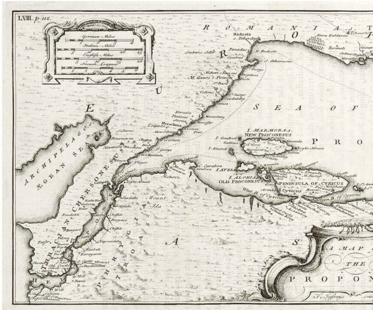
On the twenty-seventh of the month, I was at the castle with the English translator of the embassy to see the location of new and old Troy. We went along the seashore and arrived at the cape called Kepez Burnu (Kepos-bornou) by the Turks and Berbier or Berbrieri by Europeans after an hour. In my opinion, this was the ancient Dardanos cape, and I observed an artificially elevated surface where the small town of old Dardanos was. Sylla and Mithridates (The first peace treaty of the Eastern Roman Empire between Roman Emperor Sulla and Pontus king Mithridates was signed in Dardanos in 85 BC, R.A.) met here and made a peace treaty. Some say Ganymede (son of Tros, who founded Troy, Ganymede, was loved by Zeus while hunting and brought to Olympus by sending his eagle) was taken from this cape. According to some, he was taken from Harpagia, called Gyges cape, at the border of Erdek (Cyzicus) and Kara Biga (Priapus). The Dardanelles and the Sea of Marmara (1740, Richard Pococke)
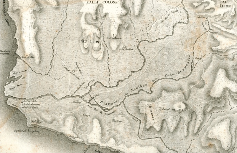
North of the place we thought to be Dardanos, there is a valley. Some parts extend to the east; this is likely the Ophrynium, where the Hector grove and Pteleus lake, said to be near Dardanos, should be. These details are mentioned in the geographer Strabo. (This is the ancient settlement immediately north of İntepe/Erenköy R.A.). I observed a swampy area covered with water nearby. Further ahead, the white heights extending to the north of the Troy plain end at the seashore. Slightly above the seashore, on a hill, should be the ancient settlement of Rhaeteum. My conclusion was that this was near the Christian village called Telmesh, or more commonly Jaurcui (Gavurköy/İntepe-Erenköy), about six miles from the old castle and approximately three miles from Dardanos. After passing this hill, I saw a high point on the slope of the sea to the south, as if it were a defensive wall, and I decided that this was west of Telmesh. Aintium, where Ajax's tomb and statue were, is mentioned as the cape near Rhaeteum, and I saw a hill rising like a mound a little away from the Troy plain. There were some marble pieces here; but it is very difficult to determine whether this is Ajax's tomb. Finally, we arrived at that famous plain at the mouth of the Dardanelles (Hellespont), two miles long, four miles wide, where the Dümrek Stream (Simoeis R.A.) and Karamenderes (Scamander) intersect and flow... To the southwest, at the entrance of the Dardanelles (Hellespont), a low hill extends near the Sigean cape. This place is called Yenişehir (Ienechahere) cape: The ancient Siegeum was on top of this cape. It was destroyed by the Trojans due to jealousy against those here. Now there is a settlement called Yenişehir (Ienechahere), but more commonly Gavurköy (Jaurcui). There are two Greek churches in the settlement, in one of which I saw the famous Sigean inscription. There is a piece of a white marble sarcophagus, with some reliefs on it that are quite finely crafted; there is also mezzo relivo (works between low and high relief) as well. A young man, whose hands are broken, holding a tool, is depicted with a melancholic expression on his face; only the part that could be the shaft of a spear is visible at the end; this most likely depicts Achilles looking at the spear that killed him (he was greatly respected here)...
The next day, on the twenty-ninth of the month, I hired two janissaries to accompany me, as the road here starts to become quite dangerous. On the low hill continuing southeast of the Sigean cape, there are three small elevations, divided into small valleys or depressions. On the next cape, there is Sigeum. On the second one, about a mile away, there is no village, but there is a small hill to the southeast, with a depression in between. On the third one, there are two small elevations; on the third elevation, there is Yeniköy (Inenecuie) inhabited by Christians. To the southeast, there is a fourth one, expanding to the north, where two rivers intersect. The high hill ends to the northeast. Here I reached the village called Bujek (Üvecik?). There are dense remains around, with many broken columns and marble pieces scattered around, and about a quarter of an hour later, there is the cemetery area of Bozköy (Boscui). There are many worked stones, columns, and pieces belonging to the cornice of a structure. I think this was once the place of Ilium, famous for the temple of Minerva. After the victory at Granikos, Alexander the Great came here and turned it into a city. After his death, it was beautified by Lysimachus. It is said that Scamender and Simois unite under this place, and old Troy was most likely on the hills above the place where these two rivers meet. At the end of the rising hill where Ilium was, there is a tumulus that could possibly be the tomb of Aisyetes (father of the Trojan warrior Alkathoos, R.A.). This is five stadia (185 m. R.A.) further from old Ilium on the road leading to the modern settlement...
About six miles east from the place thought to be the ruins of Ilium, I went to the village called Üsküpçü (Eskiupjee) at the foot of Mount Ida, where I had been mentioned to the agha beforehand. There are silver, lead, copper, iron, and alum mines here. It does not yield much profit. If allowed to work, they have to pay one-fifth of the product to the governor. This work is mostly done by Greeks (Rum) fleeing from the islands or other places. The mines are like rabbit holes, so there is no need for ropes or ladders. Alum stone is dug with pits like limestone, boiled in water after being burned, and when sufficiently filtered, alum solidifies and is processed like saltpeter (Kaluimnitrat)...
I had planned to go from the mines to Troas or Alexandria opposite Tenedos. However, the agha told me not to go there at all. Because the pasha had started searching for bandits who had spread fear throughout the region in the place now called Eskistambolu (Old Istanbul) or other nearby settlements, and the chance of capturing them was quite high. Therefore, I decided to return to the castle by another route. Nevertheless, taking a risk, we went to the rocky hill called Kızkalesi (Kis-Kalesi), resembling a sugar cone, two miles (one mile approx. 1600 mt R.A.) to the west. It has a winding path upwards. At the summit, there is a ruined castle protected by round towers at the corners. The castle gives the impression of being built hastily. In the west, there are more downward defensive sections compared to others. In this section, there are many cisterns carved into the rocks. We walked towards the tents of the poor Turkmen (from the Turcomans) Yörüks (Urukeler) living in the rocks. They only make a living by raising sheep and goats.
On the thirtieth of the month, we left the mines and reached the town called Ezine (Enai) after traveling about five miles northwest. Slightly below it, the Ezine Stream (Enaichaie) merges with the Karamenderes (Skamender) river. This should be the Andrius river, which flows from the place called Carasena region and empties into the Karamenderes (Scamander) river. The pasha had come here with his men to clear the area of bandits. Outside the city, I saw two people caught in the previous days tied to stakes. From here, I traveled along the Karamenderes (Scamander) and passed the hill where old Troy was (Pınarbaşı-Ballıdağ R.A.), heading towards the Dümrek Stream (Simois) and Thymbrius; I turned east and after a while reached the Asian castle or Çanakkale (Dardanel)...
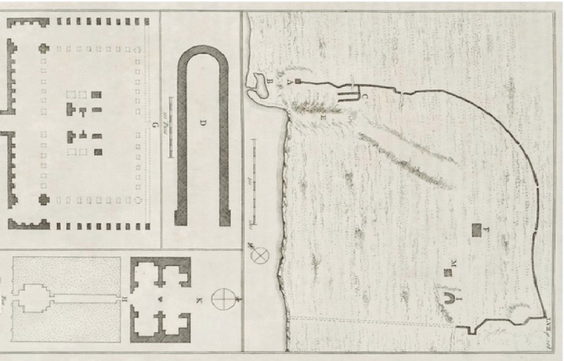
After visiting Bursa and Nice (İznik), I returned to Çanakkale (Dardanell), and later went to Eskistambole (Old Istanbul) near Tenedos (Bozcaada). This place, thought to be Alexandria or Troas, was founded by Antigonus and named Antigonia; later rebuilt by Lysimachus and named Alexandria in honor of the great commander Alexander the Great. It is thought to have been made a Roman colony by Augustus. It is located on the rocks at the end of a rising hill opposite Tenedos (Bozcaada). The walls with a circumference of four miles are visible on the surface, you can see the city plan in the fifty-seventh drawing. In the northwest corner, there are the remains of tower A; below this, to the west, there is a plain between the sea and the elevations; here are the remains of the old harbor or lake; approximately half a mile in circumference, with its connection to the sea provided by channels a quarter mile long from the sea. Along the remains of the old walls to the southeast, a little more than a quarter mile away, I came to the hipodrome or C area carved into the ground; you can see its plan under D. At the eastern end of this, there are remains of some important structures, and to the south, there is a kind of deep riverbed channel (E) going towards the sea. This must have been used to dump the fill of the harbor down in winter. To the east of this, there is a winding valley and behind it, a high area where the large temple F is located...
The city walls should be one mile long in the east-west direction, and about a mile from north to south: These two walls and structures, especially the first large temple, were dismantled and transported for use in the public buildings of Istanbul (Constantinople) by order of the current ruler as soon as he ascended the throne. It is said that the sultan had this done by a convert whom he deceived by saying that a great treasure would be found here...
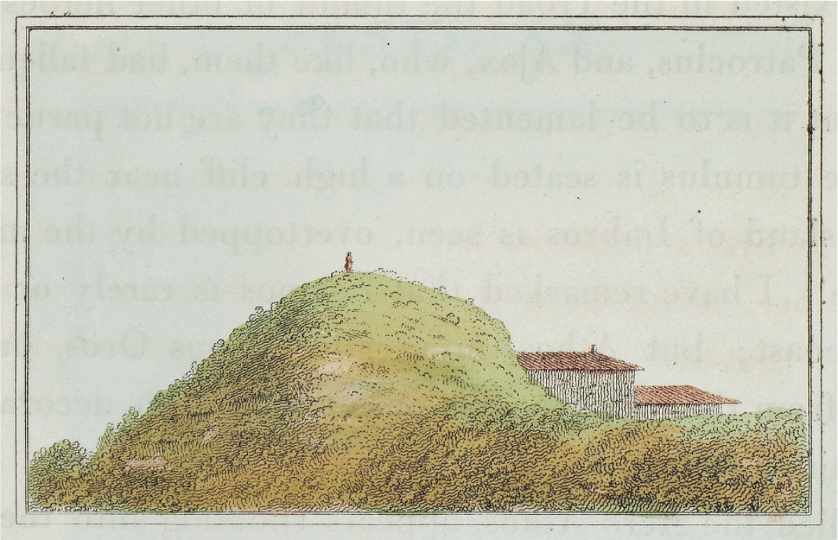
I took two Greek boatmen to accompany me, but both abandoned me out of fear and laziness. I did everything without anyone's help, but my servants performed very dangerous tasks. From here, while going to Tenedos (Bozcaada) by sea, I saw the mound between the second and third hills on the Sigean cape, they were clearly visible from the sea. This mound is most likely the tomb of Achilles, and the large white spot appearing on the fourth hill should be the tomb of Aysetes. The entire land of this city and the area surrounded by walls are also filled with trees; these trees, a type of acorn cut by the residents here, are exported to Italy as timber.
After returning to Çanakkale (Dardanell), on the thirty-first of July, I set out north towards Lapseki (Lampsacus). Between this city and Abydos, some places named by Homer are not known by ancient geographers; one of them is Arisba, ruled by Arius (Arius is the leader of the city of Arisba near the Dardanelles, described as allies of Troy in Homer's epics, R.A.) near the Selleus river.
About two hours or four miles north of the castle, there is a river named Musaköy Çayı (Mussacui-Chaie). This river should be the old Selleus, and the village of Musaköy (Mussacui) located on a gentle slope should be the ancient Arisba. Four miles further, there is a river called Bergaz Çayı (Borgas-Chaie); this should be the Pactius river mentioned by the poet. On the slope behind the plain, there is a very beautiful village named Bergaz (Borgas). In one part of the village, there are numerous spring waters called a thousand fountains."