Sir Grenville Temple, who was appointed as a lieutenant colonel in the British army in 1841, undertook a Mediterranean journey in 1834 with Lady Temple. They set off from Naples in February on a 72-ton yacht belonging to the travel agency of Sir Edward Baker. The group first visited the island of Morea, then Athens, Chios, Istanbul, Malta, and Çanakkale (Troy), before returning to Istanbul and the Bosphorus, and finally heading back to Naples. Temple published his travel impressions in 1843. Contrary to the general sentiment of his time, Temple expressed admiration for the Turks and disdain for the Greeks. With a vast knowledge base, Temple was interested in topics such as topography, classical inscriptions, and the modern Turkish army. He and Lady Temple met significant figures in Istanbul. The British ambassador, Robert Gordon, hosted them at his summer residence in Tarabya. Temple accompanied Ambassador Gordon on a visit to the Sultan; Lady Temple danced a waltz with one of the most important ministers of the Ottoman state at a diplomatic ball. After publishing his memoirs, Temple was heavily criticized by other British intellectuals of the time for his admiration of Turkish character and traditions and his praise of the approach to slavery in Islam. Some even cited him as proof that the "Philhellenic mania" (a disease of admiration for the Hellenes) was waning among travelers to the East. In his publications, he included the Greek, Turkish, and Arabic equivalents of the place names and works he encountered. His impressions of Çanakkale and its surroundings were mostly framed within the context of Homeric epics: Bozcaada (1717, Joseph De Tournefot)
"...After many tacks, we finally rounded Cape Baba (Lectum prom) and reached the beautiful and wooded coast of Anatolia, a little beyond Old Istanbul and Alexandria Troas. Here, the headwind forced us to anchor.
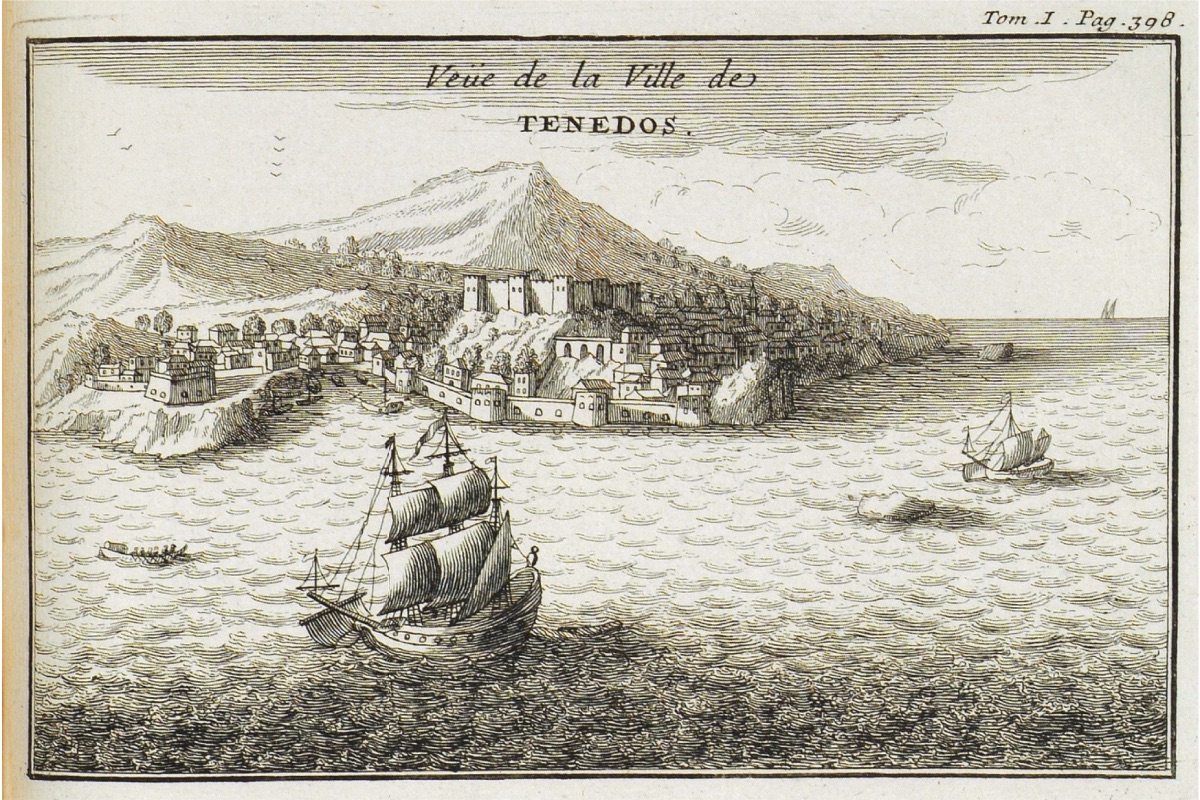
The shore here is dense with evergreen oak, known as Quareus Aegilops, which is exported to different parts of the world. The landscape is bounded by Mount Ida, known today as Kazdagh or the Mountain of the Geese, with its highest point (Mons Gargarus). The village of Tenedos, known in Turkish as Bozcaada, and the bull harbor are directly opposite our ship; the small rocky islet called Gari is not far from here.
Nağra Cape and Surroundings (1784, Aguste de Choiseul-Gouffier) As we were trying to anchor among many other sailing ships, a boat full of Greeks approached us under the pretense of selling wine, having anchored their loaded ship half a mile away from us. As we later discovered, their true purpose was quite different. Their real reason for coming was to assess our strength in preparation for an attack, but fortunately, we set sail that evening and departed. The Asia, a trading ship that arrived shortly after us, anchored where we had been, and that night sixty armed Greeks boarded, plundered the ship, wounded the captain, and took his wife. We learned these details later in Çanakkale (Daradnalles), and it was clear that those who approached us as wine sellers were indeed robbers.
We procured some of the famous Bozcaada (Tenedos) wine, which I have always preferred among Mediterranean wines. This island is also known for the Horiganoy plant, called Koiku-aoti (fragrant herb) by the Turks, and it was once famous for its earthenware. I believe either Aristotle or Plutarch, one of the two, mentions plates made of Tenedos porcelain or clay, more beautiful than silver. Teen-adom, in Phoenician, means "red clay," and perhaps the root of Tenedos comes from this name...
...
Everything we saw was very interesting to us. After wandering until dusk, we returned to the deck; but on the mornings of the next two days, we went ashore again and rode around the area on horseback as much as we could explore. The ağa of Yeniköy provided us with two horses, and since we were sufficient in number, he also gave us a sipahi or soldier to accompany us. Lady Temple had to ride the high Turkish saddle with raised edges of the ağa; it was not possible to find another one; and traveling twelve or thirteen hours a day on horseback made the journeys tiring, as was clearly evident.
I do not intend to recount minute by minute what we saw of this famous plain, which has been described many times before; nor will I reiterate previously expressed arguments or propose new theories to replace old ones with new localizations here; nor will I make any effort to assert any personal views. I will simply provide a general description of this classical site with as few words as possible and recommend Sir Gell's book to readers for detailed information, as he has seen many places I have not visited and describes the places I have visited much better, drawing magnificent pictures of them with his pen...
...
On the seventh of the month, we set sail again and shortly thereafter skirted the limestone cliffs north of the large Tavşan (Tosshan) island, then the wind forced us towards Gökçeada (Imbroz/Imbro). We then anchored under the new fortresses on the European side, called Seddülbahir (Sahil Baher), meaning "the lock of the sea." Here we had to wait until the evening of the tenth, during which time we went ashore every day.
Seddülbahir (Sahil Baher) and Kumkale (Koomkaleh), meaning the fortress on the sand on the Asian side, defend the Dardanelles, and the distance between them is four thousand yards. The distance between Seddülbahir (Sahil Baher) and Teke Burnu (Helles Bourun), built by Mehmed IV in 1659, is also four thousand yards. Today, there are two cannons with wings towards the sea on the first line with a bastion. They are commanded from a rise at the back, but the current ruler Sultan Mahmud has built a small fortress on it. There are about fifty cannons, mostly made of brass, and some of the lower ones do not have a wheeled carriage system, with a triangular protrusion on top, allowing their position to be changed directly with pulleys and ropes. These granite cannons can reach the opposite Asian shores. I did not like the appearance of the soldiers in the garrison, as in Egypt: their clothes consist of a brown jacket, loose trousers reaching the knees, and a tight legging...
Kumkale (Koom-kaleh) is a four-cornered fortress surrounded by towers and can be commanded from the heights of Yenişehir (Siegeum / Orhaniye tabyaları) just a thousand yards away. According to what I was told, there are one hundred and seven cannons of different calibers.
Nearby Seddül Bahir (Sahil Bahir) is an important village or small town with many factories producing cotton goods. On the rise behind the village is a tumulus believed to be the tomb of Protesilaus. On the road to Gelibolu, there is a rather peculiar structure, a water aqueduct or water terrace. It consists of a square, with freestanding columns or towers, and inside the space, there are solid pipes rising to the top of a small reservoir where waters from the pipes on the opposite side are collected. The next column is lower, and these form an inclined plan across the valley.
While walking through the village full of soldiers, with a Christian woman dressed in her country's clothes, whom they had probably never seen before, we did not encounter the slightest harassment. On the contrary, many soldiers helped us shop or showed us different places. But as soon as we left the village, we found ourselves being followed by young soldiers who fired at us and harassed us, and although we did not argue with them verbally, they threw stones and fired rifles at us. Nevertheless, when we threw a few paving stones right into their midst in response, they immediately fled, uttering the most severe curses and insults in Turkish...
...
On the evening of the tenth, we set sail again, but we could only travel five or six miles towards the harbor called "Tacchia bianca" (white bay/Akbaş Limanı) by the Italians on the Asian coast. The following evening, we sailed along a varied and beautiful coastline with hills, trees, and some very pleasant valleys. On the left, we saw the tomb of a Turkish saint, which the sailing ships of this country salute as they pass. As we passed the mouth of Sarıçay (Rhodius), we saw the very powerful cannons of the old Asian fortress of the Dardanelles, Kale-i Sultaniye (Sultan Kalaahsi). We were suddenly dragged to Berber (Barbier) cape, where we anchored in a surprising manner. Our captain, like all other captains, took his usual disadvantageous position above the fortress with his ignorance and determination. Early the next morning, the British consul in Çanakkale (Dardanelles), Mr. Lander, came aboard. He brought very good quality fruits as a gift and took us to his house, where we had dinner.
The pasha of the region sent one of his officials to us politely, saying that he was sorry he could not host us at his palace as he had to go inland shortly, but that we could use his horses while we were at Kale-i Sultaniye (Sultan Kalaahsi). We met him while walking around, accompanied by about twenty cavalrymen. In front of him stood two guards with light-barreled rifles, like the English mounted guards. All the horses looked like very valuable animals, and some, unexpectedly, had English-style harnesses. Hacı Ali, a talented and enlightened pasha, is partly Frank. He is likely married to the daughter of the most powerful Turkish ruling family, the Kara Othman Oglou (Kara Osmanoğlu)...
...
The part of Çanakkale (Sultan Kalaahsi) we toured is very beautiful, mostly covered with fertile and well-maintained gardens. The view of the Sarıçay (Rhodius) bed is magnificent. Especially the place covered with green grass and shaded by large maple trees, where Turks and Greeks celebrate together on holidays. A part of it belongs to the pasha. A little further away are hills with different elevations, covered with forests where wild boars, deer, rabbits, partridges, and woodcocks play. The fortresses here, but also those on the European side, were built by Muhamed II el Fatah (Fatih Sultan Mehmet). The sea side is defended by numerous cannons, while the opposite side is protected by walls with towers, with a castle or fortress in the middle. It is built on the sand of the right floodplain of Sarıçay (Rhodius). This river's floodplain can become swampy, and in my opinion, this water can be easily diverted with a dam, which would protect the fortress from attacks. Perhaps this is the only defensive wall in the Bahri Sefid strait (Bahery Sefeed) floodplains that cannot be conquered by land; most of the others are commanded from a nearby height. There are one hundred and ninety cannons of different sizes here...
Due to the very strong currents in this section, the sailing ships of different countries passing by create a beautiful view of the Dardanelles (Hellespont) from the windows of Mr. Lander's house. The European fortress, the village and cemetery around it, Eceabat (Maidos), Akbaştepe (Sestos), and other visible places add another beauty to this beauty with the magnificent valley nearby, where the pasha's harem often goes for walks and stays.
In Kilidbahir (Kileed-Baher), there are very powerful cannons at sea level, and the surroundings of the towers are surrounded by double walls; there are also removable cannons standing alone against the current a little below. The fortress with sixty-four cannons is built on a sloping rise and is commanded from six hundred yards away and a slightly higher point. The Asian and European fortresses are generally referred to as the Çanakkale Fortresses (Chanak Kalaahsiler). While watching our ship's sails not open and drift towards the current in the strait; when it was not possible to board the Denwant, which had to anchor again due to the contrary wind, Mr. Lander took us back to accompany us on his boat. We had previously passed by Çimpe (Zemenik), the place where the Turks first crossed to Europe with their soldiers. According to the Takweem Towareekh of Hajji Khaleefah (Katip Çelebi), this significant event took place seven hundred and fifty-eight years before the Hegira (1357), carried out by Süleyman el Ghazi Pasha (Süleyman Paşa), the eldest son of the second Turkish ruler Aorkkhan (Orhan). Forty men pretending to go hunting on the shores of the Dardanelles (Hellespont) crossed to the European shore at midnight on two rafts made of inflated oxhide and made a surprise landing at the fortress called Çimpe (Tzympe). It is now called Çimenlik (Dshemenlek). They forced the inhabitants to cross to the opposite shore with all their boats, gathered them all on the opposite shore, then returned with four thousand soldiers and soon defeated the Greeks and conquered Gelibolu (Gallipoli).
Here we also passed Akbaş Tepe (Ak-bashi, Sestos) and Nağara Burnu (Nagara, Abydos)."