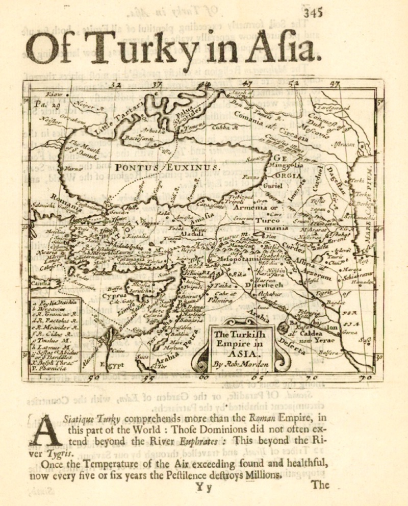
The Dardanelles and Troy on the Map of Anatolia (1687, Robert Morden) The French traveler and artist Guillaume Joseph Grelot stayed in Istanbul for over a year in 1677. After returning to his country, he dedicated his book, which consists of drawings and memoirs published in 1680, to King Louis XIV of France. In a time when there was great competition among travelers, Grelot's book achieved significant success and was even translated into English three years later. The text and illustrations in the book diplomatically strive to convey to the king how beautiful and important Constantinople is. Like all European travelers, Grelot does not use the name Istanbul, which the city was given after 1453, due to his Christian devotion. Almost all European travelers culturally and politically divided the city into east (Istanbul) and west (Constantinople). By using this name, all Europeans, especially the French, thought they had reconquered the city in another sense. This perspective can be seen in Grelot's descriptions of the Çanakkale region. Particularly, his admiration for Greek culture (Philhellinism), his condescending view of the Turks, and like all other European travelers, his interest in Troy come to the forefront:
"The famous strait, also known as the Hellespont, is located at 17 degrees and 42 minutes north latitude and 55 longitude. Its length is approximately ten or twelve leagues (1 league is approximately 5.6 km). The width at its entrance is one and a half leagues. To the left towards the west, you see the lands of Thrace, which is part of Europe.
Troas, divided by the Çanakkale Strait (Hellespont), remains on the eastern side. To the north is the Sea of Marmara (Propontis), and to the south, along with the peninsula, is the Aegean Sea.
At the entrance of the strait on the right, the Sygean cape extends towards the sea, where there is a small village inhabited by Christian Greeks (Sigeion/the Greek village Yenişehir abandoned in 1922, R.A.) known as Janisary cape.
The Turks call this place Giaourkioi or the Infidel Village; this name is generally used for places without a mosque. It is near the famous city of Sygeum in ancient times (Sigeion/the Greek village Yenişehir abandoned in 1922) and is called Troyaki or Little Troy by the people of this region. Travelers can rest well here and buy very nice food such as chicken, eggs, partridge, rice, butter, melon, and fruit at cheap prices. One hundred eggs for twenty-five cents; this is four or five akçe, also not more than two sols in French money; a dozen chickens or chicks for half a piastre, which is not more than 30 French sols. The water here is very good and tastes nice; but that's not all; at a distance of one League (1 League = 5.5 km. R.A) on the island of Bozcaada (Tenedos), magnificent muscat wine is produced, and you can buy a large barrel for a Crown (22-carat gold coin) for very little money. From this extension or cape, it is worth watching the beautiful lands of Troas, the Karamenderes River (Xanthus/Scamander), and the Dümrek Stream (Simois); the sources of both rivers originate from the famous Mount Ida. These two rivers owe their fame to the ancient poet, as the beds of the rivers are not larger than the Gobelins stream in Paris. Sometimes in the summer, they almost completely dry up; but at other times they join where Troy is, and here, surrounded by a large swamp or lagoon, they flow under a wooden bridge supported by stone columns. Not far from the new castle in Asia, about one League from this cape, they flow into the Çanakkale Strait (Hellespont).
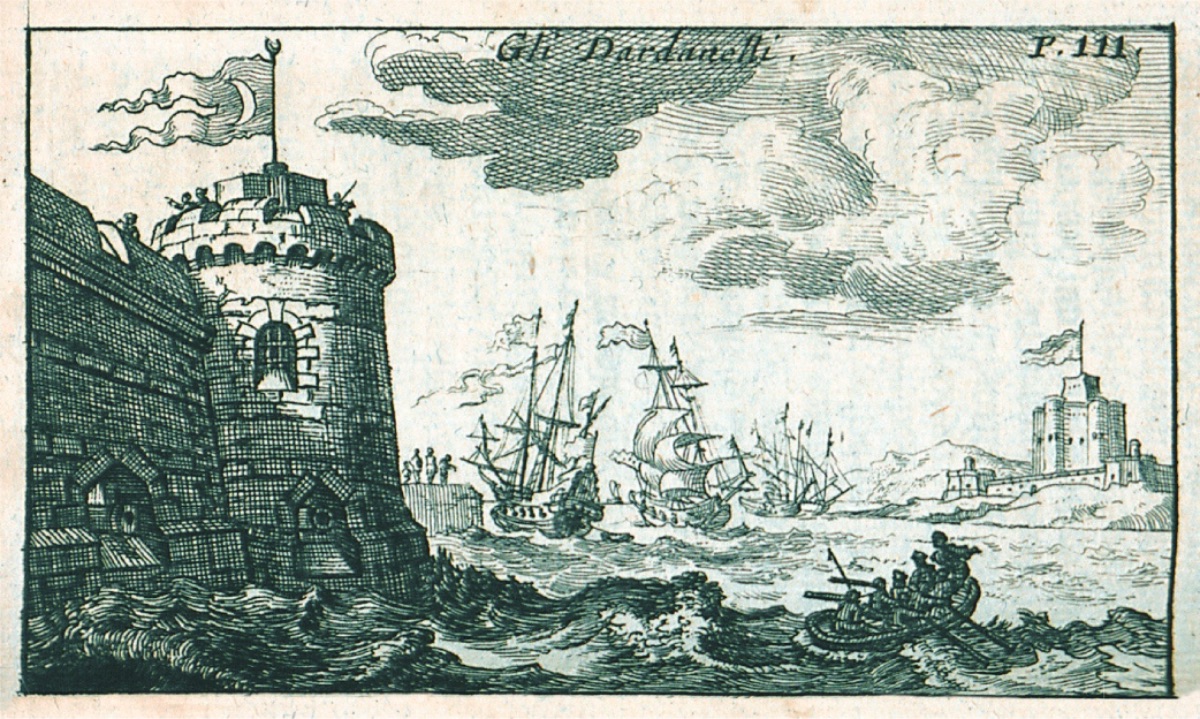
The Turks, who have never been interested in liberal arts, instead of building new and magnificent structures according to the strict rules of architecture, turn their works into ruins by using ancient artifacts. Therefore, despite being aware of their ignorance in this matter, it is not surprising that so many errors and irregularities appear in the new castle in Asia opposite Europe (Old Kumkale R.A.); similar errors can occasionally be seen in the castles and bastions they build. This castle is located on a square platform consisting of four large wall sections. Of the bastions in the form of towers at its four corners, two close to the castle are angular, and the other two are rounded.
Among these four towers, there are five more that support the walls, four of which are angular and one is round, but none of them match each other in thickness, size, and distance. Those washed by the sea and the wall holes on the platform are quite flat due to the water surface. As I mentioned above, there are cannons ready to fire at the enemy who dares to pass the harbor with danger and adventure in forty of these cannon holes. Fortresses in the Dardanelles (1686, Jacob von Kurtze)
However, despite the effort and money spent on these castles, a naval force, even if it attempted an attack with all its fury in a given situation, would not need to fear the power of the cannons here. All the cannons are mounted only with large stones or square timbers without a frame or wheeled carriage. Therefore, once fired, it will take quite a long time to reload for firing again. At any time, it would not be so difficult to demolish the walls of the castle with two or three cannon shots; the three feet thick walls I mentioned above, to hit the ears of the soldiers and the cannons. This means that the castles have no function and will soon surrender to the storm. The road to this castle is easily accessible from the north, from the tower where the church and temple are; at the end of the road, not far from the cape in the south, there is a very beautiful mosque.
Between this new castle, which the Turks call Anadolu Yeni Hisar (Natoli-inghiissar), and the Yenişehir (Janisary) cape, in the northeast, is the village of Yenihisar (Inghi-issar-kioi), meaning the town of the New Castle. There is nothing significant here, except when you walk towards the Yenişehir (Sigeon/Sygean) cape, you see eight windmills standing on poles. As is customary throughout Turkey, each mill has eight blades: Undoubtedly, this gives great power to the millstones to grind and mix the grain. Because there is very little bran in the wheat ears here, the bread eaten by the Turks is never as white as ours; this is because too much fine bran comes out with the ears from between the millstones.
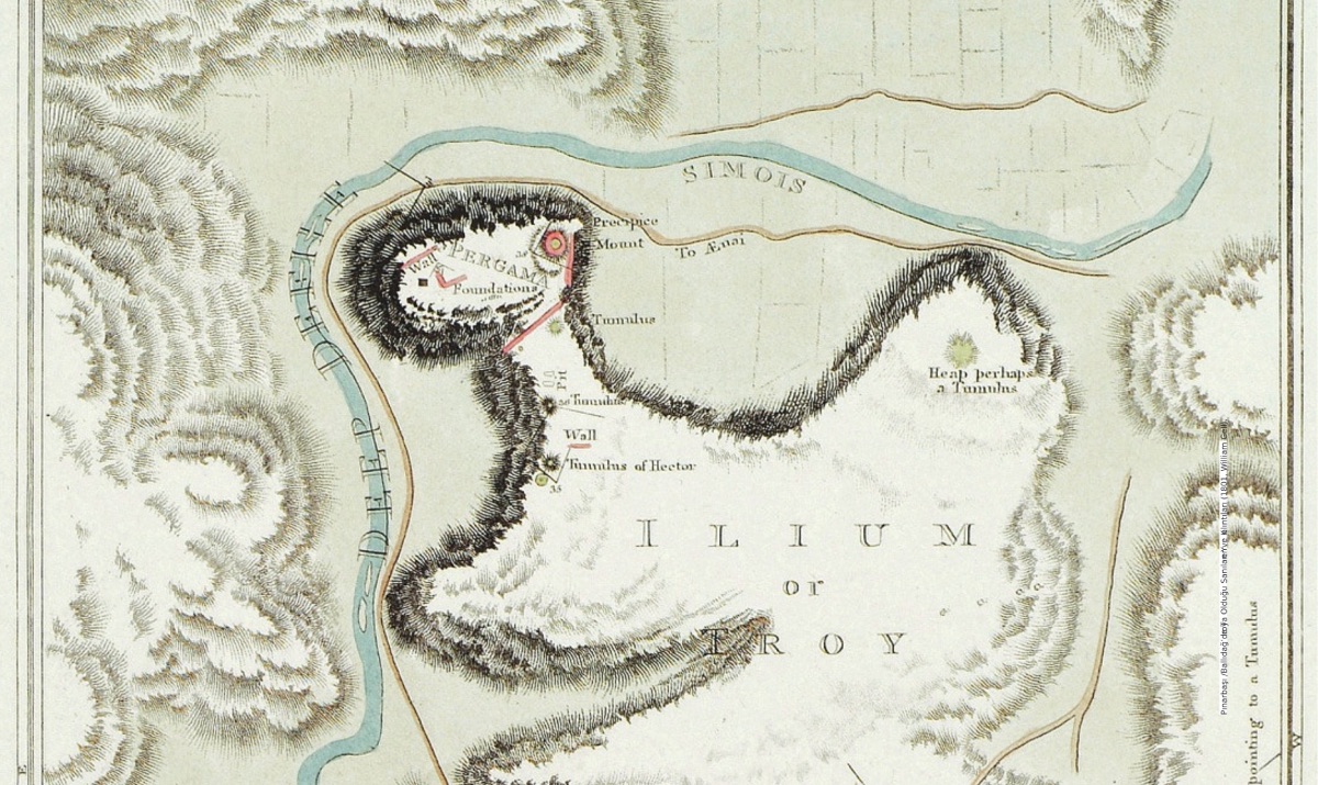
Pınarbaşı _The Place and Ruins Thought to be Troy in Ballıdağ (1801, William Gell) Now, as the time has come, let me talk about Achilles. Like many Greek captains who anchored at this cape, while describing the well-known city of Ilion, the unfortunate remains here are not only waiting to be discovered at the Sygeum cape but also at sea and on Bozcaada (Tenedos). However, since some travelers wrote before me, I will say nothing more than the following: Considering how long ago the remains of this great city of Troy and the numerous marble columns and other pieces have been reused by the Christians and Turkish rulers residing in Istanbul (Constantinople) in churches, mosques, palaces, baths, and other public buildings, the fact that some remains and broken pieces of Corinthian architecture still remain; requires us to definitely confirm that Troy was the most beautiful, richest, and largest city of its time. A large part of these ruins was later thought to be the ruins of the Greeks' fire; therefore, Roman emperors and Augustus sent many colonies to restore the city to its former glory. However, we cannot conclude from this whether the city ever returned to the glory and fame it had during the glorious time of the unfortunate Priam. Despite the long-lasting restoration works, we understand from the following lines of Lucan, who witnessed what was done a century later, that it did not change during his time (Marcus Annaeus Lucanus, a Roman poet who lived between 39 AD and 65 AD, referring to Emperor Caesar's visit to Troy, R.A.):
Now barren bushes and oaks stand
Where once stood Assarcus' palace,
The temple of the god bound by its own roots
Lies with its fortress beneath the ground.
...
Very few people who go to see the ruins of Troy visit Bozcaada (Tenedos) right across from here. This island is very beautiful and, in addition, has deliciously beautiful wine. Also, hawk hunting is enjoyable on the island; therefore, there are plenty of wild birds here, abundant muscat wine, but also plenty of other delicious wines.
The harbor is not very large, suitable only for small Turkish ships or small sailboats, but it is not possible for large ships to enter the harbor.
However, no matter how bad the harbor is, a large castle and warehouses have been built here because the island has a great function in controlling the Çanakkale Strait (Hellespont), the Sea of Marmara (Propontis), and the Thracian Bosphorus, and in maintaining sovereignty over the islands.
During my stay on the island, two single-masted French ships on the way came to anchor. Just as Turkish ships or small boats forced me, a passenger traveling from Smyrna (Izmir) to Istanbul (Constantinople), to take refuge in Bozcaada (Tenedos), they also forced the French to the same shelter. Some French officials who had to take a break in this harbor came to the shore, run by a Greek who spoke Italian, where I was staying, to relax a bit. When they arrived, I was sitting at a table with a young Turk who, like the others, was not very religious about drinking wine, especially since he had found his way to Bozcaada (Tenedos) with such beautiful wines. However, due to my Eastern habits, my long beard, and my conversations in Turkish with the men I traveled with, the French did not think I could be one of their countrymen, and I understood everything they said. They were openly chatting with each other, and after talking about their glasses, they started talking about the Turkish and Greek women on the island and other islands.
For a while, I did not say a word to them, but I continued to talk with the Turks next to me until I heard their rather cheerful jokes while drinking wine; I could not hold myself any longer. So I started pretending to be Turkish. I said that I was in France with the caravan of Mustafa Agha, who returned a year ago. I spoke to them frankly in French, like someone who was angry about some things: "How can you, who seem to be French, talk so shamelessly and insultingly about our women in our country while drunk? Look, gentlemen," I said, "they are more respectful than you according to reason and tradition. And you should think that there might be someone who could think of bad things. While you have been accepted into such a well-ordered Empire, you are abusing this goodwill. They (the women) go out so little outside their doors and attend so few public meetings and gatherings that. When they are sometimes allowed to go out for their worship, they walk with their faces covered with veils, and they dare not speak to any man they see on the road; but French women, on the other hand, can go out alone without caring and I told stories about their bad sides. And therefore, I continued to talk; I told them that they should not be so rude on such sensitive matters again... I had never seen anyone so surprised before... Later, when they raised a glass for the king, I told them I was from the same country as them... And so the joke ended with one, two, or many more glasses of wine until the bottle of muscat wine was finished. When the wind changed the next night, we set sail at sunrise and left Bozcaada (Tenedos).
After leaving Bozcaada (Tenedos), we sailed towards Yenişehir (Sygean Cape) and came between the two new castles between Europe and Asia. I had described one before, now I will describe the other.
This new castle on the European shore, which the Turks call Rumeli Yeni Hisar (Rumeli-inghi-isar), like the one opposite, was built by the 23rd Emperor of the Turks, Sultan Mehmed IV. Despite being subjected to ineffective attacks by neighboring enemies due to its magnificent position overlooking the hill; it has always been believed that it is impossible to pass to the Sea of Marmara (Propontis) due to its advantageous position in the Çanakkale Strait (Dardanels); as a result, Istanbul (Constantinople) is secured against attacks from this side...
After passing these two castles, you come to the section of the sea called the Çanakkale Strait (Hellespont) or the Arm of Saint Georges, with its bays. This place has always been the scene of famous events. For someone who knows Greek and Latin and understands modern history, this place is like a feast of memories... The people of this region, both Greeks (Greeks) and Turks, are so ignorant that asking them any questions or expecting them to show the place where the unfortunate Helle drowned is a futile effort... They have no knowledge of the city of Arisbe mentioned in Homer's great work. They are unaware of the plateau where the brave Ajax's tomb is in the city of Raetion, now near the New Castle on the Asian shore, nor do they know Xanthos and Simois adjacent to the nearby mountain...
The name of the old castle on the Asian shore is also similarly Anadolu Eski Hisar (Natoli-iski-issar). It is square-shaped, with towers at the four corners of its wings. Those facing the sea are also four-cornered, but they look towards the land and around. In the middle of the castle is a large angular tower, on top of which many cannons are placed. As a result of a shot fired from this tower, Lazaro Mocenigo lost his life (after giving the second defeat to the Turkish navy in 1657). While cunningly planning to pass through the strait in front of these castles and bombard Constantinople, he was unfortunately hit by this shot in this honorable expedition. Behind this castle is a large village with a population of three thousand, some Christians and the rest Turks and Jews (Çanakkale). Although it is not very important, it is important to command the large cannons without carriages facing the water in the strait crossings, as in the New Castle...
The castle on the European side, which the Turks call Rumeli Eski Hisar (Rumeli-iski-issar), is more irregular and not as strong as the one on the Asian shore. It is located on the slopes of a hill and is controlled by three large interconnected towers in the shape of a heart. These towers, circular walls, and half towers descend to the harbor. Here, thirty cannons are positioned towards the water like on the other shore, and they have the same cannonballs... Many believe that these two castles and the town were built next to the ruins of the ancient cities of Sestos and Abydos... Frankish and European travelers to Turkey name these two castles Dardanels, after Electra, the daughter of Atlas, and Dardanus, the son of Jupiter, the first king of this region, and they name the city he founded after himself as Dardanum and the surrounding area as Dardani. Vergil (the author of the Aeneid, the poet of Roman Emperor Augustus (70 BC - 19 BC). These epics trace the roots of the Romans to the Trojans, R.A.), considers this city to be the same city as Troy and according to him, Tros is the grandson of Dardanus and the father of the brave Ganymede. Others want to convince that the ancient name of Dardanum, established on the shores of the Çanakkale Strait (Hellespont) where Dardanels is now (Çanakkale), has been preserved and thus the new city established on the Karamenderes (Xanthus/Scamander) was first called Dardanum, and later Troy and Ilium..."